Hurricanes Rafael and Paul.. Could Sandy be out there somewhere??
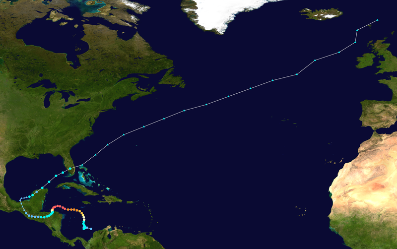
Hurricane Rafael, upgraded last night to hurricane status, is beginning to affect the island of Bermuda with some winds and distant squalls. He is a big... a HUGE system and even after he is gone they will most likely get something from his long tail. He has an elongated appearance, not the most tropical looking system but a Hurricane none the less.

The track after Bermuda has him clipping the Canadian Maritime Provinces and they are issuing their own information from the Canadian Hurricane Centre.

Hurricane Rafael currently has 85 mph winds and is headed NNE.. enough of a movement to the right to spare Bermuda a direct hit.
"
...RAINS FROM RAFAEL HAVE BEGUN IN BERMUDA...


SUMMARY OF 200 PM AST...1800 UTC...INFORMATION
----------------------------------------------
LOCATION...29.5N 64.4W
ABOUT 195 MI...315 KM S OF BERMUDA
MAXIMUM SUSTAINED WINDS...85 MPH...140 KM/H
PRESENT MOVEMENT...NNE OR 15 DEGREES AT 23 MPH...37 KM/H
MINIMUM CENTRAL PRESSURE...969 MB...28.61 INCHES"
From the Canadian Hurricane Centre:

What a great idea, the map with the cone over a real time satellite. Love it!
Here's a link:
http://www.weatheroffice.gc.ca/hurricane/track_e.html
There's a nice link to Bermuda Radar on www.spaghettimodels.com.

The coverage there gets better and better. It's my one stop shop for all my info... though I still surf around to my long time favorites.
Still wondering if this is it or it ain't over until it's over. Sometimes a season like this has a late season storm buster that shows up and explodes in it's way and takes people unaware. Our minds are on other things. We are watching CNN or FOX and talking politics and football... the World Series and the after discussion on the World Series.
Hurricane Opal was such a storm, late in September and early October. The whole world it seemed was watching the trial and waiting to see if OJ was going to found guilty or not guilty. No one was paying attention to the Gulf of Mexico. Suddenly Opal was a big news story of her own.
http://en.wikipedia.org/wiki/Hurricane_Opal

Hurricane Lenny: http://en.wikipedia.org/wiki/Hurricane_Lenny
Same time of year.. Hurricane Mitch, big bad storm from the SW Caribbean:
http://en.wikipedia.org/wiki/Hurricane_Mitch
Back in 2005 we were watching Hurricane Wilma this time of year:

Notice a consistency here? SW Caribbean... down near Jamaica, touches the Yucatan and takes off at some point to the NE or NNE.
The models that we are all watching carefully on each run show a system in the Gulf of Mexico in a little over ten days. That's long out, but it has been consistent with showing something forming.
This image is up on Mike's Facebook Page that is connected to his SpaghettiModels site.

Look at that. Could that happen? A lot of circles there, it would be a strong system if this model reads things right.
Join the discussion:
https://www.facebook.com/pages/Mikes-Weather-Page/88134562366
You can also talk to me on Facebook as well as on Twitter.
https://www.facebook.com/bobbi.storm.5
https://twitter.com/BobbiStorm
Let me know your thoughts.
Is the Tropical Season over or.. are can the GFS be right with the formation of a system in a little less than 2 2 weeks. Hard to say, always been told not to trust a forecast more than 5 days out...
Check out the link below. Notice on October 19th..20th..small lows show up in the SW Caribbean. On the 29th of October, hovering over Jamaica a system starts to really form... and then moves North over Cuba. Does it go into the Gulf or NE into the Atlantic.. or slide west again into the Gulf? November storms are so flakey they need their own shrinks to try and figure themselves out.
http://raleighwx.americanwx.com/models/gfs/00zgfs500mbHGHTPMSLtropicalGFSLoop.html
I don't see where it forms unless it crosses over from the Pacific or oozes over and or up from South America... a weak West bound wave? The Pacific is pretty busy right now as Hurricane Paul moves towards Baja California. Though he is weakening, as storms always do at that point, he is still a Category 3 Storm.. most likely downgraded shortly as he doesn't look good on satellite imagery. Then again, he looks better than Rafael. Since he is affect the "Americas" I'm posting on a EPAC storm for a change.
So, the search goes on for Sandy. Note all the way at the SW bottom of this loop is a slight curvature of some convection partially cradled over water.. party over land. This happens often.. perhaps there is some energy down there we fail to notice while looking north at frontal boundaries and Rafael moving towards Canadian waters.

In this current water vapor loop you can see both Rafael and Paul:

![[Image of 5-day forecast and coastal areas under a warning or a watch]](http://www.nhc.noaa.gov/storm_graphics/EP16/refresh/EP1612W5_NL_sm2+gif/175136W5_NL_sm.gif)
Sweet Tropical Dreams,
BobbiStorm
posted by BobbiStorm @ 1:53 PM
![]()


0 Comments:
Post a Comment
<< Home