A writer and a tropical muse. A funky Lubavitcher who enjoys watching the weather, hurricanes, listening to music while enjoying life with a sense of humor and trying to make sense of it all!
Wednesday, July 03, 2024
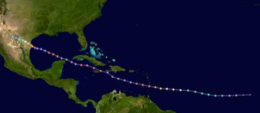
Quick Update on Beryl at 8 AM - Hurricane History Allen & Georges .. Similarities and Differences and Track Wise Similar For Stubborn Movement WNW Across the Caribbean.
WNW at 20 MPH.
Bit slower than it's been.
But only 2 MPH different.
145 MPH still formidable storm.
Remember the core of Beryl is small.
Intense eye and eye wall.
It looks larger on satellite imagery.
Models
From SpaghettiModels
Models disagree on end game.
Clustered tight short term.
Models disagree on Intensity.
What do you do?
If you are anywhere to the North of this track, you monitor the hurricane and pay close attention to any changes in track or discussion from the National Hurricane Center. Again the NHC not some cool dude on TicToc or some rumors you heard on WhatsApp but stick with the real deal as the NHC IS the real deal. Follow those online who you enjoy reading, talking to and learning from who have regularly never steered you wrong. But bottom line is the Cone from the NHC. That said, the map below is from a reliable source that has a good history of providing additional information in easy to read graphics.
They are good to follow.
It's a great APP.
Read the details they give.
96L still exists with current low chances.
But it's been gaining color and size.
Just a wave... a weak Invest.
But don't forget it's there.
Here's the set up.
Beryl center stage.
96L behind it showing signs of life.
Stagnant boundary across ...
Upper GOM coast & into ATL
Next frontal boundary moving down...
Little convection in BOC singing "come to me"
This blog has two parts. The first part is what you just read about the current state of the tropics, NHC info on Hurricane Beryl set to take on Jamaica and then Caymen Islands before going ... just where? I will update later with new information from Recon, the NHC and anything important in saying regarding Beryl from satellite imagery. Today is about preparing for the arrival of Beryl and whether the eye tracks across Jamaica or misses it by a li'l bit ... it's going to be some big blow to the beautiful Island where Blue Mountain Coffee really comes from and where several of my friends in Miami were born and have told tales of Gilbert...they always talk about Gilbert.
The rest of the blog is about Hurricane History and it takes a look at both Hurricane Allen and Georges, two hurricanes that have similarities to Beryl despite their differences. I wanted to look back at just why Allen did the long stubborn track it did and why Georges stubbornly went WNW over every piece of land it could find before crashing into the Upper Gulf of Meixo Coastline. I'm looking at their persistence, their ability to bounce back and keep on trekking WNW as Beryl has done and I am really, really ready to retire the name Beryl.
With prayers for all those in the path of Beryl and hoping everyone has done what they can to safely ride out the storm that has a history of being deadly, destructive and difficult for forecasters to forecast due to it's early arrival in late June and models that differ in both track on the end game and intensity. As always Intensify forecasting is the hardest and it's the intensity that often tells the tale. Both Allen and Georges were mighty good at intensity, rule breaking and going the distance.
Thanks for reading. If you aren't interested in the Hurricane History part of this blog, continue down to the bottom for the Song of the day ;)
I fell asleep early last night around 10 PM and woke up at 3 AM wide awake with tons of thoughts running through my head on how we have all been trying to understand the Enigma of Beryl.
There's always an analog, even if sometimes you have to blur the parameters and take the best guess theory. Kind of like best track?? I digress... Hurricane Allen, being August and early in the season, with a stubborn WNW track seemed a good analogy, as good as any. Allen was August a month later into the Hurricane Season and early enough in August for fronts to be fairly irrelevant. A strong high and a long tracker all the way to Texas. The biggest difference between Allen and Beryl is that Allen was huge in size and Beryl has always had a small core within in larger pocket of moisture.
I have to say I was in LA during Allen's trek across the Caribbean though we did take a road trip to Miami later in the Summer or early Fall. I was watching earthquakes and geology and probably at The Odyssey Disco in West LA or hanging out at the end of the Sanata Monica Pier and hurricanes were happening far away back "home" in Florida. So I had to really go back through NHC reports to read up on how Allen unfolded in real time to get where it ended up.
Memorable image of Allen.
People in SFL could look up ...
..and see clouds from bands of Allen.
Below you can see stubborn Allen.
Again the pattern made it stubbornly move WNW.
Relevant discussion to explore in many ways as Allen was a record breaker as is Beryl, and both traveled a similar path through the Islands Allen going throug the Islands just South of St. Lucia and it's only 130 miles from St. Lucia to Grenada. Then Allen stayed just South of the Dominican Republic, as did Beryl. The quote from the NHC report regarding Allen's records for lowest recorded pressure across the East Carib is shown below.
" At 8:00 PM AST August 4th, reconnaissance aircraft found Allen had reached category 5 strength and recorded a minimum central pressure of 911 millibars (26.90 inches). The 911 millibars was the lowest recorded pressure across the Eastern Caribbean Sea. Maximum sustained winds of 180 mph (155 knots) were recorded later that evening into the early morning hours of August 5th while Allen was passing south of the Dominican Republic."
Allen, like Beryl, flirted with Hispaniola and dumped copious amounts of rain on it yet the eye did not goi there... it moved on, and Allen began to weaken from a combo of eyewall replacement cycles and a good part of it's circulation over the mountains of Hispaniola. Old time weather people on air would wax poetic on this in that the eye doesn't have to go over the mountains for it to have some disruption and displacement of the overall circulation hampering further intensification. Allen continued on to deal with Jamaica and Cuba, much like Georges mentioned below it just kept on going.
"August 5th through the early morning hours of August 6th, Allen began to weaken as it took a jog to the northwest and passed just south of the western tip of Haiti. The weakening was likely due to the combination of an eyewall replacement cycle and disruption of the overall circulation from the mountains of Haiti and the Dominican Republic."
At some point Allen found a sweet spot again and found it's groove and reintensified back to a Cat 5 traveled through the Yucatan Channel and made landfall near South Padre Island and the Port Arthur area. A legend in it's time and still one of the most intense hurricanes.
Now let's look at Georges
Hurricane Georges
1998 a very stubborn Georges ignored NHC...
... kept missing chances to turn North.
I was back in Miami I remember it well.
It raveled across more land than ....
....any storm I could remember.
And, kept going strong .
Another rule breaker.
South Florida was a blaze with hype on Georges and only 6 years after Andrew they saw shades of Andrew in Georges and every other storm that looked as if it might come close. After an Andrew type hurricane the locals keep their guard up and pay close attention. As Georges approached the Islands the NHC suggested it might turn. Locals worry on hurricanes than come up over the Islands towards Florida. But no it went through the Islands and then it was suggested it would turn before PR. But it tracked across PR and without barely a burp ignoring any chances to deviate from it's track and continued on to Hispaniola, totally ignoring weather experts insisting that the high mountains would disrupt it's circulation and kill it off. It did have to catch it's breath again after Hispaniola intensity wise and it kept going same direction despite any discussion of a coming turn. Miamians watched nervous as it approached Cuba and experts said it could turn soon by Cuba and many Old Timers remembered Cleo that did that trick before hitting Miami but...no it did not turn. I remember my daughter Dina, a young girl obsessed by hurricanes after Andrew turned to me exasperated at TWC and said "What don't they get it's going to keep going WNW until it's ready to turn" and she was right. It did most of Cuba may I add before finally taking a small turn and trashing Key West on it's way to yet another landfall near Biloxi impacting that whole region of MS/ALand the FL panhandle that once all belonged to the the Republic of Florida.
Final Landfall of Georges.
From the start Georges was "that wave" the kind that rolled off of the African Coast by Dakar in Mid September with a circulation and signs of low pressure from the start. A mere two days later a closed circulation was observed and it was upgraded to Tropical Depression. Due to the steering currents that year, a strong High steered stubborn Georges across the Atlantic to it's date with the St. Kitts and Antigua, PR, Hispaniola, Cuba, Key West and then the Gulf of Mexico coastline in Mississippi ...and Alabama and parts of the Florida Panhandle that ALL got hit hard!
There was shear from an Upper Level Low but rather than curving up towards the North it continued on due to a strong High Pressure area and honestly it kind of followed the ULL as many hurricanes have over time. They either disrupt them, enhance them or become part of the overall steering currents for the hurricane. I will admit after every land interaction Georges did take a hit in intensity and then it bounced back and kept on going being referred to if I remember as the Energizer Bunny.
"Once back over water, the hurricane began to re-intensify." Basically was the pattern of Georges magical journey through the Caribbean.
Even at the end it stubbornly held on as seen from the NHC prelimnary report below.
"Georges became quasi-stationary for the next 6 to 12 hours moving in a
cyclonic loop over southern Mississippi. The tropical storm began moving in a
generally northeast to east direction early on the 29 and was downgraded to th
a tropical depression by mid-morning while located about 30 n mi northnortheast of Mobile, Alabama. Georges continued to move eastward at 5 to 10
knots on the 29th and 30th
. By early morning of 1 October, the system
dissipated near the northeast Florida/southeast Georgia coast, although a very
weak remnant low did emerge over the western Atlantic during the day.
However, the remnant circulation merged with a frontal zone"
Bottom Line.
While it was late in September that much of the drama with Georges was occuring it was a strong, stubborn, rule breaker hurricane that marched to it's own beat and was a long tracker WNW most of the way as seen below similar to Beryl. Only when things changed and allowed it to nail Key West (an island that rarely gets hit dead on, much like Grenada) and move up towards the Upper Gulf of Mexico Coastline was the long tropical drama finally over. The clean up in all of those places it hit went on and on for a long time.
How it was different from Beryl is that it is early July, not yet July 4th even, and while we do have fronts on the move they aren't as strong and the High currently IS still strong. IF the frontal boundary gets stronger and the High weakens then we can talk on fantasy forecasting and wonder if Beryl has a chance at getting West of Texas and the Sabine River. I'm not shutting the door on it in anyway, just at the moment we are going with the track WNW into Tex/Mex or pulling to the right and flirting with Texas as Alberto did and the tropical Depression did and well is the 3rd time the charm?
Again Beryl has a small core this is the biggest difference between it and Allen and Georges. Systems with a small core can intensify fast and they can also unravel fast. And, sometimes while unraveling in a big messy pocket the center can shirt to another strong area of convection further North or South and then the game changes. I'm not implying this will happen, I've seen it happen. I've seen a lot. Beryl has new tricks up it's sleeve often, but eventually all hurricanes run out of time, water and land.
Location: Miami, Raleigh, Crown Heights, Florida, United States
Weather Historian. Studied meteorology and geography at FIU. Been quoted in Wall Street Journal, Washington Post & everywhere else... Lecturer, stormchaser, writer, dancer. If it's tropical it's topical ... covering the weather & musing on life. Follow me on Twitter @ https://twitter.com/#!/BobbiStorm


0 Comments:
Post a Comment
<< Home