A writer and a tropical muse. A funky Lubavitcher who enjoys watching the weather, hurricanes, listening to music while enjoying life with a sense of humor and trying to make sense of it all!
Friday, August 13, 2021
UPDATED 6 PM TD7 - TD FRED DOING CUBA (as I said it would...) 95L Forming into Grace 80% Now But Fred Frustratinig Forecasters in Florida Forever - Still Messy But Moving WNW Still Has Potential.
Florida is barely in the cone anymore.
And Fred is OVER Cuba... closer to the S Coast.
Expected to move WNW eventually ... again.
The NHC wrote a discussion shown below in the link that basically said what I said at 3 PM ...in that Fred did Cuba, is much further to the "left" (South and West) than expected tho it is still expected to bounce up and follow the plan. The cone they put up is to the East still of the models, though the models are further to the West. One or two model runs really need to be consistent and to see consistent movement from Fred before running off and following any one model run.
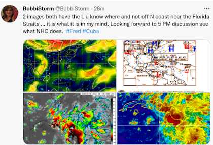
I have no idea what the NHC will do at 5 PM regarding Fred playing a Trick on Friday the 13th but Fred is not where it was forecast to be. Hey it's close... Cuba there is very narrow. Fred likes land. Why it wanted to retrace Georges Track I don't know but it's wandered around more real estate in the Caribbean than most Tropical Systems have done that had way better circulation. Note the picture on the top right... High Pressure to the North and a Low to the South below the L they placed on Cuba. Image on the top left has the L over Cuba (not the North Coast) and that same area has been flaring up all day. Below you can see a closed Low ... maybe Fred... just S of Cuba now as it's seemed as if it was going West all day despite being forecast to move WNW. Time will tell what will be with Fred. Glad I don't work at the NHC it's not easy being the bottom line and even models have moved further West avoiding Florida more and more heading up into the Gulf of Mexico... Kind of always been a crapshoot hasn't it?
Fred did Cuba as I said it would probably do. The forecast movement is for the future forecast period in fact I believe it's going more West than WNW but when it emerges off of Cuba we will see once again if Fred can live up to it's potential. As I show in the blog below written around 8 AM and still relevant.... Fred could get up into the GOM and have more warm water and time over warm water and that would be a real wild card. Earthnull shows it anchored over Cuba moving Westish ...let's say North of West and models still make it a player in the NE GOM near Florida/Alabama and what it comes down to is TIMING. If Fred dawdles over Cuba too long (friction sometimes gets a vote on forward speed) it may interact with that diving trof that I'm skeptical is diving so harshly, but would LOVE any cool respite from the horrible heat of August. See living in Raleigh I know I can wait it out, but in Miami it's almost never ending until the last week of November for a few months until it gets horribly hot again.
Again Fred will energize the humidity and severe weather over South Florida (Miami area) even though it's not in the Cone. Let's wait and see what will be.
As for PTC7 the models show it moves towards Fred's track it could pull North in latitude and cruise through the Bahamas and threaten a Florida landfall while people in the Carolinas smile and think "nah it's a Carolina storm" and only time will tell. Truly that's the way it goes always.
I dislike model reliance vs using the models for hints as to what a storm will do. A well developed storm with a closed low, an eye and a donut ring of convection around said eye will more likely follow models but be off on intensity as we are far from solving that puzzle. Messy systems with multiple centers are hard for models to grasp and grab onto and they do the best they can. The forecaster then looks at all the data from Recon and uses mutliple layers of satellite imagery as well as knowing well CLIMO and having a deep knowledge of hurricane history and upper atmospheric synoptics before making a forecast.
A newbie goes by short term models and the model they like and they learn on the job as it takes a long time of studying tropical weather to really understand it's unique issues. Yes sometimes you get someone young like Levi Cowan and even he is careful not to go out on a ledge too much rather than explain to you what IS going on currently. Weather people are NOT interchangeable though a winter weather specialist can get to know hurricanes and tropical meteorology and a tropical met can learn the difference between a Miller A and Miller B storms but it takes a while before they see the patterns in the new field.
Nothing like Tropical Meteorology, though I'd add trying to nail down a snow storm in the Carolinas just 24 hours out is a big deal. Easier to forecast where a Hurricane will go when it's rolling along steady over time.
Keep reading down below and note how the models disagree with regard to Hurricane Grace.
Note I put the models up because it's not until the models fire off a few strong hurricanes that often don't materialize exactly in several days ....that you know you are getting closer and closer to Prime Time in the Tropics and I feel y'all need to GET A PLAN!
With so many Hurricanes turning away from Florida, especially South Florida, residents new and old are beginning to believe there is some magic force field that will protect them from a landfalling Major Hurricane. Nice to believe but don't bet on it! Get a plan please!
* * * *
Read the 8 AM discussion...
...and check out Grace's possible future.
Maybe yes, maybe no.
Time will tell
Is that Grace's face :)
Not in love yet with it.
Not giving up on Fred either.
Some paraity in this pictures.
N/S alignment within systems.
Fred on the N Coast of Cuba.
Literally on the coast if you ask me.
Strong convection to the South.
95L now at 70% in the 2 day...
...top half took over but still blob to the S.
Soon a "track map" will be up for 95L
Cone for Fred.
Devil is always in the details.
Discussion tells the story.
Still fighting shear.
ULL to it's North riding it.....
...ripping it's attempts at development.
Someone give that ULL an award.
Otherwise we'd have had a hurricane.
Key point: Heaviest rain/wind on East side...
Why is that important?
Fred has been a mess by our traditional standards doing everything wrong and crawling along with a mid level center to it's South that is stronger than it's actual center the NHC has been tracking officially. I've said this a million times a hurricane is a real viable storm well developed stacked and vertical. Tropical Storms, especially the last few years where the NHC veered violently from their Rule Book and upgraded crap waves to TS status .........we have ended up with misshaped, misaligned, messy tropical disturbances being named and never living up to expectations. On rare occasions one has come together suddenly and made the grade to real, dangerous hurricane. Dorian is an example, it did not look well until it came together literally over the Virgin Islands (Hurricane Surprise) and then exploded to the NW of there as it slammed into the Bahamas. Most of the piddly tropical storms have limped along until the NHC pulled the plug when they were safely away from populated area.
With Fred moving steadily towards Florida it's harder to blink and pull the plug, because many people in Florida are going to get a mess of weather (including Miami) far to the East of the Cone. What you saw last night with that nonstop lightning storm may be Fred whispering your name. Fred always wanted to do Miami but it never could pull it together and it's final destination is still a beautiful beach on the Florida Panhhandle. Miami to WPB gets a mess of weather, makes national news with images of flooding and Fred slides up to the West along the West Coast of Florida.
My concern is that Fred has always managed to find land rather than avoid it. The center is hard to see now if there really is a center, but it's also over Cuba vs the off the North coast of Cuba in my opinion and I'm good at this. Fred took on the whole island of Hispanoila, something Isaias that had long range travel plans was careful to avoid as did what became Dorian. Then Fred moved on to Cuba and slowed down noticeably.
Fred just is what it is and I have said from day one if you go back through my blogs is that I have said CONSISTENTLY from DAY ONE that the REAL CONCERN for FRED is LONG TERM ...DOWN THE ROAD ...IF and WHEN it gets CLOSE IN Near Florida. The concern has always been what Fred does near Florida either on the East Coast or the West Coast and if it visits Carrabelle good for it as it's a beautiful place to be. Crystal River works too IF the front really dives down deeply, sharply but otherwise it's St. George Island or somewhere in that general region as an end game. If the NHC pulls the plug on TD Fred (just after they insisted they would upgrade it to Tropical Storm soon) they will have to follow it as an Invest so one way or another it gets to see the West Coast of Florida while flooding out cities outside the cone on the East Coast if models for precipitation play out.
As for 95L that should get the name Grace sooner rather than later it has real possibilities for trouble. It could flirt with the Islands (Virgin Islands probably) and slide to the North of Fred's difficult trek through the Caribbean. People in Florida will worry and wonder, whereas people in the Carolinas will be sure it's coming for them while disblievers will insist it's a Fish Storm. Models have been consistently West they implied a curve and then headed back towards the West again today. Check out that intensity model that shows a hurricane, a healthy hurricane. Not perfect, but closing off a center!
BOTTOM LINE:
Miami to WPB will get serious weather, but you are used to serious weather, you COULD get WIND impacts but it's not a for sure it's a happening in real time in which case pay attention to my friend Phil Ferro who is more into warning you of the weather than hyping it or putting agendas on it. Some mets in the area go long on what they think will happen on Saturday but don't warn you on Thursday evening you will get nonstop thunder and heavy flooding rains. Always amazes me that some METS love to pose for the media, find the story they think will sell and yet miss the real story. One thing about Phil, who does work at a station often accused of hyping the news is he never really does and he stays online in real time updating a storm with hard data vs playing up some angle that the media might grab onto faster. Phil Ferro is real and a really good metoeologist and the Miami viewing area is lucky to have him. Miami also has a great NWS as does Key West (love that place) so use them for local impacts..
NAM good for the short term.
And this is short term forecasting.
The once mighty EURO shows it further to the West.
But all the weather is playing with Tampa Bay.
What will Fred do?
WNW at 10 MPH currently.
Tampa is a concern, honestly as Fred has hugged land more than any storm since Georges but luckily is messy Fred not Georges. Both of these models show the Tampa area (and that includes Naples to the South) will get storm surge (more than you'd think for a messy TD) and that water can pile up fast in low lying areas. Strong storms as it moves North towards it's real landfall the models have been insisting on but with messy tropical disturbances you watch in real time.
www.windy.com
Euro on the left. GFS on the right.
Next Sunday evening Hurricane Grace.
Or not.......
Some models imply that's the next wave...
...not Grace.
We will see ... give it time to come together.
As for Grace/95L the GFS sees a mighty hurricane, the EURO sees nothing like that. Someone send some Tagamet to the people at the NHC as the forecasting misery will go on another week.
In 2 weeks we should have less Upper Level Lows, warmer water and better waves with better structure as they develop into dangerous hurricanes. So enjoy these mixed up, messy systems because we are still in Pre-Season the real Hurricane Season usually ramps up around August 24th!
I'll update later in real time and on Twitter all day long.
Hello everyone, I want to say a special thanks to Dr OGU. for helping me get cured from herpes virus 2019 , I contacted him base on the testimonies I saw about him on the internet I was diagnosed of HERPES Virus i have tried all I can to get cured but all to know avail, until i saw a post in a health forum about a herbal man who prepare herbal medication to cure all kind of diseases including HERPES virus, at first i doubted if it was real but decided to give it a try I was cured by his herbal medicine and natural herbs, kindly contact him today through his email: drogugusolutionhome@gmail.com or text/call: +1 (719) 629 0982
He’s waiting to help you.
HE ALSO SPECIALIZE IN THE FOLLOWING DISEASES;
If you have any sickness like : H I V/AIDS , CANCER , HERPES HSV 1 or 2 , GENITAL WARTS, Yeast-infection's (HPV), and Hepatitis A, B. liver diseases , Diabetes, 1 or 2. , fibroids, Chlamydia, Genital herpes, Alzheimer’s, Trichomoniasis , Tuberculosis, CAD, Gonorrhea, Epilepsy, and Syphilis.
Location: Miami, Raleigh, Crown Heights, Florida, United States
Weather Historian. Studied meteorology and geography at FIU. Been quoted in Wall Street Journal, Washington Post & everywhere else... Lecturer, stormchaser, writer, dancer. If it's tropical it's topical ... covering the weather & musing on life. Follow me on Twitter @ https://twitter.com/#!/BobbiStorm


1 Comments:
Powerful Herbal treatment is 100% guarantee.
Hello everyone, I want to say a special thanks to Dr OGU. for helping me get cured from herpes virus 2019 , I contacted him base on the testimonies I saw about him on the internet I was diagnosed of HERPES Virus i have tried all I can to get cured but all to know avail, until i saw a post in a health forum about a herbal man who prepare herbal medication to cure all kind of diseases including HERPES virus, at first i doubted if it was real but decided to give it a try I was cured by his herbal medicine and natural herbs, kindly contact him today through his email: drogugusolutionhome@gmail.com or text/call: +1 (719) 629 0982
He’s waiting to help you.
HE ALSO SPECIALIZE IN THE FOLLOWING DISEASES;
If you have any sickness like : H I V/AIDS , CANCER , HERPES HSV 1 or 2 , GENITAL WARTS, Yeast-infection's (HPV), and Hepatitis A, B. liver diseases , Diabetes, 1 or 2. , fibroids, Chlamydia, Genital herpes, Alzheimer’s, Trichomoniasis , Tuberculosis, CAD, Gonorrhea, Epilepsy, and Syphilis.
Post a Comment
<< Home