Major Hurricane Joaquin a Slow Motion ..Train Wreck. Rain Keeps Training In the South, Mid Atlantic Bch Erosion and High Surf Warnings

Joaquin is pulling away from the Bahamas ....
...and headed towards Bermuda it seems.


...and headed towards Bermuda it seems.


Discussion from Beven at 11
Bermuda may be more in the cross hairs now..


You can finally see the forecast ULL reaching and pushing him away. Moving off towards Bermuda and the Atlantic Ocean. He is retracing his steps like a Boomerang Hurricane. Hopefully he will miss Bermuda as it's just a dot in the middle of the Ocean. But...there are watches and warnings up.
Note this was from 5 PM.
At 11 PM they were upgraded to Hurricane Warnings.
Not a good sign.
Neither is Joaquin's fast forward speed.
NE at 20 MPH...
You can compare the 11 PM Discussion above..
...with the 5 PM Discussion below.

At 5 PM Avila said:


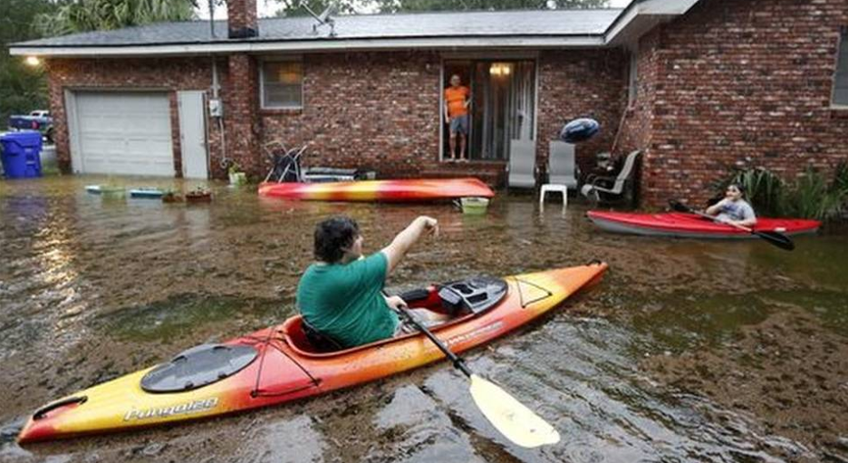
This picture is from earlier today.
When the "fire hose" effect from Joaquin was in place.
And, it was lashing Charleston with endless tropical rain.
That's what we call a training effect.
Like a big, wet, choo choo train going down the tracks.
Over and over.
Ever be stuck at a light when some lonnnnnng freight train is passing...
....and it feels it will never ever end?
A new Flash Flood Warning is up for Charleston tonight.

That is what happens when this set up happens.
The rain keeps coming.

Remember the other day when I commented Joaquin was getting a trunk?

The reason I pointed it out was...
..often that trunk in upside down Canes act like a tail.
Hurricanes come in all sorts of shapes.
Some have long tails that dip down to the equator ...
Others have a curved trunk.
Sometimes they develop a long band ...
....that attaches to another storm behind them.
Joaquin had a long trunk.
And he shot rain out of that trunk at the Carolinas.
Call it a fire hose or a trunk the story is the same.
Huge amounts of tropical rain aimed at Charleston.
And, a lot of other nearby cities.

A whole lot of rain.
And the rain fell in places few spoke on.
Parts of Georgia inland had flooding rains.
Charlotte up the road from Charleston had flooding.
Some great pictures online that I will post at the bottom.
Right now the images of Charleston with some flooding rain..
reminiscent of Hugo without the wind damage are on hold.
There is a bigger story.
There is a missing freighter.

Seems like every Major Cane like this one has a lost ship story.
Sad, but true.
http://www.dailymail.co.uk/news/article-3258249/Coast-Guard-searching-missing-cargo-ship-33-crew-Hurricane-Joaquin-batters-Bahamas-125mph-winds.html

"Tote has insisted that Hurricane Joaquin
was classified only as a tropical storm
when the vessel set sail on 29 September."

http://www.dailymail.co.uk/news/article-3258249/Coast-Guard-searching-missing-cargo-ship-33-crew-Hurricane-Joaquin-batters-Bahamas-125mph-winds.html

When I was 13 I read a lot on the Bermuda Triangle.
In the Pacific there is an area called MU...too.
This was from Cat 4 Joaquin...
I think she is hoping for any happy ending.
And can you blame her?
This quote tells the whole story.
Well...how the story began anyway.
Read the story...
"Tote has insisted that Hurricane Joaquin
when the vessel set sail on 29 September."

33 people are missing....
A life ring was found about 120 miles NE of Crooked Islands in the Bahamas. The ship is still missing. Search conditions have been terrible according to Lt. Commander Gabe Somma speaking on TWC. They are hoping search conditions will improve and as the weather moves off to the NE they will have better conditions. It has been confirmed the life ring was from the missing ship, but added it could have come off in bad weather earlier...
I have serious problems with TWC when they show a LIVE news segment flashing "LIVE" at 8:30 PM of a reporter in Charleston that was taken earlier when it was daylight in Charleston. Spoiler Alert the sun is NOW down in Charleston so the segment was taped and NOT Live. I love you guys.. really...but let's stay real please.
And Charlotte did get weather and damage.
It's not all about Charleston but we do love Charleston Down South.

Note in the Bahamas Joaquin has taken many lives. The total number has not been discovered, but we should know more tomorrow with better weather and daylight. Heartbreaking loss of life really.
http://www.tribune242.com/news/2015/oct/03/joaquin-becomes-tenth-named-tropical-storm-atlanti/

This was as devastating as it gets for that part of the Bahamas.
And, it bothers me a lot that they were being ignored by many.
Not the NHC that was posting watches and warnings.
But there was so much discussion on the end game with Joaquin.
Debate on the model shoot outs as if this was a sporting event.
Or a gambling event.
I'm sure there was a line in Vegas for the Euro VS the GFS
So much hype on SANDY THE SEQUEL...
While it spun and spun edging slowly SW towards trouble in the Bahamas.
But that fact was ignored by many who only wanted to be right on "landfall"
Well... Joaquin made landfall IN the Bahamas as a Major Hurricane.
While people waxed poetic placing bets on Ocean City or OBX or NYC.
No... the truth is few were discussing the reality.
The reality being that part of the Bahamas went through a 2 Day Hell.
A Major Hurricane just pushing water up with no where to go.
Storm surge, winds... nonstop bashing the Bahamas.
Here is some video posted on www.canetalk.com a message board hosted by www.hurricanecity.com and it is from yesterday ..but you get the idea.
News is often locational.
A big story in the NE sells.
Charleston is Historic.
OBX screams HURRICANE

One day Cape May and Ocean City and Virgina Beach will get their Cane.
Today they got beach erosion and rain.
The $$$ damage amount will be high...very high.
Across a huge area.
Drudge got that right.

And as much as Drudge loves history and a good story...
The story keeps going on and on.
It is far from over.
The rain will continue to pound in tonight and tomorrow.
High Tide follows Low Tide.
The rivers are not yet filled up and then...
....they may not stay in their banks.
Pray.
This is far from over.

Ryan Maue quoted this as being "slow motion disaster"
And he is right.
He is one incredible meteorologist.
One of the best we currently have.
He can write, speak and put out awesome computer graphics.
He's good. He got it right.
A slow motion train wreck I may add... up and down the East Coast.
TWC is on it...

Stay tuned...this is so far from over.
I'm updating in real time.
I mean Joaquin is a work in progress.
This morning people thought he has peaked.
Then he intensified.

What will tomorrow bring?
Besides rain and high surf and ...add in wind for the East Coast?
Which side of Joaquin will Bermuda see?
Speaking of trains....
Amtrak service along the East Coast IS affected.

http://www.amtrak.com/service-alerts-and-notices
This is a developing story....
The models did a great job with track..
Okay the EURO did a great job with track.
But they were awful with intensity.
Early on ... no one saw Major Hurricane coming.
And then they all one by one climbed on board the model train.
Besos Bobbistorm
@bobbistorm on Twitter
Ps..

20% Yellow Circle in the Atlantic.
Nope...the season is far from over.
But we will talk about that later.

posted by BobbiStorm @ 7:09 PM
![]()


0 Comments:
Post a Comment
<< Home