A writer and a tropical muse. A funky Lubavitcher who enjoys watching the weather, hurricanes, listening to music while enjoying life with a sense of humor and trying to make sense of it all!
Wednesday, October 12, 2022
Updated! 5 PM........ 60MPH Winds Found By Recon............Karl, Sheared System with Moisture (RAIN) Flying Off Towards Florida BUT a Cold Front Approaches....... October Funky System
I always said I love NHC headlines.
KARL FORECAST TO MEANDER OVERNIGHT...
Recon found Karl stronger than was expected and they issued a special statement earlier today to say Karl was now 60 MPH. What's significant about that is that they never had 60 mph in the forecast, let alone the next advisory. As you can see from what I wrote earlier ... Karl looked great on Earthnull and basically recon just confirmed what we already knew. Looked best on Eathnull and that indicated it was tightening upand strengthening. There are a few stray models that do odd things, but in general they show what the NHC Forecast Cone shows and that is basically after meandering over night Karl crashes into Mexico and tries to get into the Pacific again. Karl should be wearing a black tee shirt with the slogan "Never Say Die" but we will see if Karl reforms in the EPAC or not eventually.
What does bother me is the forecast for intensity.
Totally off on forecast intensity.
This is from earlier... one model showed it a bit.
Most did not.
I dislike when models are so off...
but not going to obsess over it.
Gotta run ...
...be on later tonight.
Seems like Karl has some surprises up it's sleeve.
But in the end the strong front pushes down...
..and NHC insists the high pressure will make him go S.
Into Mexico.
We will watch in real time.
Not ruling anything out this season.
Again it's about the weather.
And weather is being sheared off...
...towards Florida.
And SW Florida doesn't need any rain.
But hey it's Florida, it rains.
Please keep reading.... and thanks!
Models for Karl look like Burning Man...
Hang Man?
Stuck in the BOC...
..and it's moisture streaming NE
Filling up the GOM due to shear.
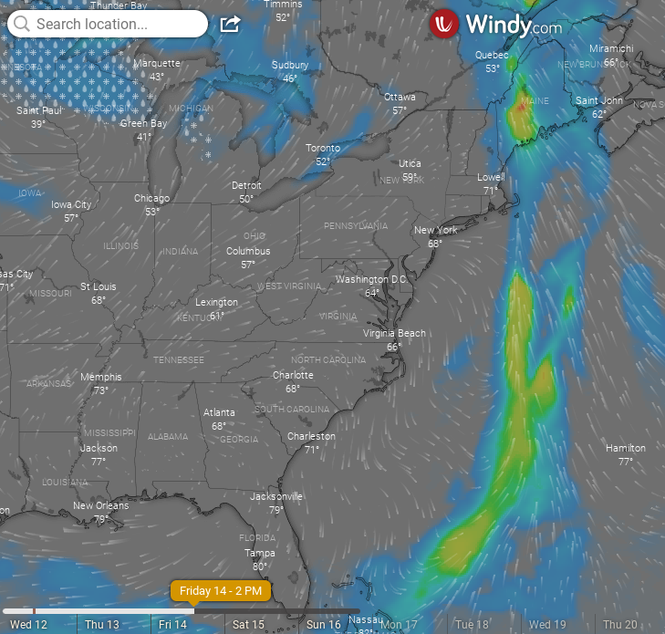
You can see this in the image above.
Draw a line NE across the Gulf of Mexico.
Karl looks crappy on satellite imagery.
Looks better on Earthnull.
I don't want to say the NHC kind of blew this but obviously I am. Julia did move West but the other part of her wandeerd away and this was always on the table but dismissed as a possibility. And, as always they can put up a new yellow X which they did but time line was off and it should have been more obvious this would happen.
Generally storms have two options here. Loop about a bit in BOC and then make landfall in Mexico. Or they get picked up as very sheared systems and try and move back towards the NE or ENE even towards Florida. And, sometimes like with Karl the moisture sling shots off towards Florida because of the shear and eventually when the steering currents become more set in stone the storm crashes down into Mexico again. Or you know if this October feels like late October/November they find a way to stay alive but not really moving much and just spinning. Looks like Fall but feels like Winter is closer than we thought this year.
Look at that cold front from Windy.com
NAM on Friday.
I'll update later when new models run.
Models have been pulling "East" as per NHC.
Discussion had lots of dance steps this morning.
You know how the warning on the cone says...
..impacts outside the cone.
I think we need to look at a weak tropical storm as a weather maker and in this case moisture flying away from Karl is enhancing rainfall in the Gulf of Mexico especially in Florida. And, with fronts coming down it's also an issue as when cooler air hits warm moist air it ups the ante for severe weather somewhere along the frontal boundary. And, all of that while Karl sits spinning closer to land in the Bay of Campeche. IF Karl was a well developed system things would be different. But it's not and it is what it is and that means shear is picking moisture up and flinging it towards Florida in bits and pieces.
Let's just see what happens.
This time of year storms get "funny"
....and this year cold fronts are STRONG!
Stay tuned...
BobbiStorm
@bobbistorm on Twitter and Instagram
An old favorite song of mine from way back when. There's pieces of Julia everywhere and yet you can see on Earthnull Karl has a "center" and that's something. No one wanted Julia or Karl after Ian, people want it to go away fast and yet Karl won't. There's a piece of energy in the East Pac from Julia and a piece in the BOC known as Karl and pieces of Karl's moisture flying off to the NE. Stay tuned. Here's my morning song for you reading this wherever you are ...
Location: Miami, Raleigh, Crown Heights, Florida, United States
Weather Historian. Studied meteorology and geography at FIU. Been quoted in Wall Street Journal, Washington Post & everywhere else... Lecturer, stormchaser, writer, dancer. If it's tropical it's topical ... covering the weather & musing on life. Follow me on Twitter @ https://twitter.com/#!/BobbiStorm


0 Comments:
Post a Comment
<< Home