Henri Threatens NY NJ and NEW ENGLAND LANDFALL on SUNDAY!!!! - Pay Close ATTN to Local Watches (now up) and Warnings!

Grace is behaving but threatening landfall.
A strong hurricane currently on track.


That is my "not rant" on the problems this seasons with forecasts and the models. Yes in the end they get it right but for an agency that wanted to move out into 7 day Cones they have had problems verifying their 5 day cone without making large adjustments. Now we are in the 3 day range.
Sunday.
Today is Friday.
Do you know where you will be when Grace is progressing North? Talking the whole Mid Atlantic here not just NY and NE!


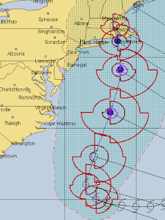


Update at 11 AM shows the NHC nudged their cone further to the West but East of many of the models clustered to the West of the current cone. The door is open to nudge it further to the West and everyone from NewYork City to Cape Cod needs to pay attention to the exact track of Henri as it approaches landfall after it begins moving North having been "caught" by the "trof" if all goes as planned. Also areas far to the West of the Cone that have beach and coastal interests need to follow Henri and be aware of it's presence and I mean from Myrtle Beach North through the Outer Banks and up into the Del Marva including Chesapeake Bay (that is MY concern I wish to get across to you) as the exact track is based on the exact location of the center and the NHC has been vocal on not being sure where that is. I will not begin to go on a rant as to how ridiculous that is because we have so many ways of slicing and dicing it. Yes it may be tilted but the center is very visible across many avenues of research. The center that is visible is not exactly the center they are supporting in this race as per their long discussion explaining the problems they are having. They did this with Fred and that's why it went the length of Cuba before even thinking about moving North.
Tropical Systems from Tropical Depressions to Tropical Storms to even Hurricanes are not always neatly aligned vertically as sometimes they are "tilted" and other times they have a Mid Level Center that is really "driving the movement" but the NHC puts the "official center" into the models and then when the models come back with bad data they blame the models. Models are not HUMAN they are fed information and if they are fed junk food they vomit out bad data that goes into the forecast. As in the case of Fred it didn't take the turn to the North before Hispaniola or over Hispaniola or before Cuba but after doing Cuba. Grace slid along the bottom of Hispaniola and slammed into Jamaica and there was very little discussion about Jamaica in the forecast package until Grace looked up and screamed "Hello Jamaica!!"
With regard to Henri the difference it makes is Cape May gets way more than they expected (not just high surf) and Delaware gets storm sure and the whole coastline there is filled with inlets and bays that run from North to South so Henri moving North along that coastline closer to it than the cone now implies pushed storm surge and flooding way up into some heavily populated areas that are commuter towns for the people who work in Washington DC. That's just an example of a possibility. It's also possible it stays neatly offshore but until it begins that turn and we see what the speed is and if it intensifies all bets are off.

Update will be after the next model packages come out and the 2 PM intermediate advisory is issued.
Keep reading is you did not the blog will be updated after the next set of model runs before 5 PM>
& * & *
8 AM Discussion

So preapare but be aware of any changes.


posted by BobbiStorm @ 5:20 AM
![]()


0 Comments:
Post a Comment
<< Home