Updated! Tropical Storm Kate. Forecast to Curve Away from Florida. Watch for Rip Tides. Is there another storm after Kate? Some say maybe

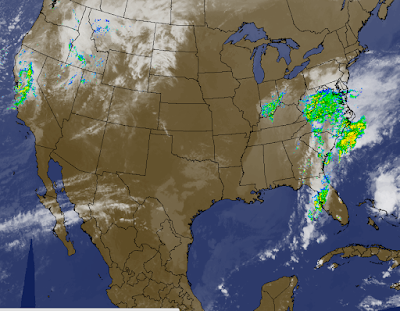
You can clearly see Kate's circulation here this afternoon.
Moving fast. I'll do a close up.
NW at 15 MPH
(seems faster to me...)
45 MPH Winds.
Nothing else new.
Read on...
New picture shows it well.
The front is visible like one big red Twister.
Kate a solid white ball of tropical weather.
Looks awfully close to South Florida.
Moth attracted to the flame.
Use this link and click on the cities in the path... airports.
http://wxweb.meteostar.com/tropical/gfs.php
You can see what the weather is in Nassau...
I'll be back with a full, new update after the new discussion from the NHC.
Not expecting many changes, maybe intensity.
Keep watching.
Things moved fast this morning with TD 12.
NHC upgraded her to Kate so fast the graphics packaged lagged behind.
:)
Come on... this was not that hard a call to make to have to wait for the A Team to come in on Monday morning and do the upgrade. I love recon, it's an awesome tool ... love those dropsondes and new radar imagery from the planes (what an idea) but really ...this was a done deal to be Kate late yesterday. Annoys me as I like truth in forecasting and discussion.
They were quite honest this morning that last night's main modeling package didn't see the small lunge west in track that brought it closer to Grand Bahama that was not seen by the main team of models ... most likely as it's a "small system" and we have been told endlessly this year small systems are not picked up well by the traditional big girl models.
Reminds me of the song.
Now let's dance to the loops.

If you remember I mentioned the fly in the ointment with the forecast..
..was the timing.
Kate is in a hurry to get somewhere fast.
Also over warmer water closer to the Gulf Stream she finds abundant heat.
Looks better on Dvorak too...

Well not much better.
But it's a definite...entity with a name.
Since I tend to be old school...even tho I'm complaining.
Let's look at the old school Unisys loop.
Note the approach of the front...

This is a shallow system, small and still not well organized.
One reason the traditional big gun models are not doing well with it.
To understand this well you may want to read up on models.
They are not all the same.
http://stormfacts.net/models.htm
On www.spaghettimodels.com scroll down to the smaller links.
Good info there on models. Random stuff is always good :)
http://www.nhc.noaa.gov/modelsummary.shtml
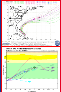
Models still show a healthy recurve may I add in here...
Even if Kate is rushing towards the approaching cold front.
My gosh her track is way off the track...keeps going to GB...

To quote an old friend from VA on AOL...
"Oh look it's a tropical storm!"
Well I do believe they said Hurricane but this IS a TS so...
Radar Love
Use this link to see up to the minute data...
http://www.blitzortung.org/Webpages/index.php?lang=en&page_0=30
I've outlined the front and the weak tropical storm named Kate.
That image is from Accuweather
Kates's gonna curve... she's got a curve coming up.
Just when she curves is the question.
Watch out for rip currents in South Florida for now...
Cute song.
Really looking for a real hula hoop song.
My daughter teaches hula hooping but I rarely put personal videos online..
She's due soon... taught hula hooping this summer while pregnant.
This hooper actually has better curves than Kate right now..
Keep watching...
Intensity models keep going up as she inches more west than NW.
But that will change soon... in limbo waiting for that turn...
Earlier...
Just a matter of degrees.
We go with the consensus so... keep watching.
More later today.
Stay tuned for updates as NHC nails down this storm..
..faster than you can see drop a dropsonde in me..
Oh and some people think the season does not end with Kate...
Just putting it out there...
Besos BobbiStorm
@bobbistorm on twitter
Ps... any typos this morning.... sorry ;)
It's a Ferris type of day today I think..
;) not sooo old school but appreciate all the data from all the right sources


0 Comments:
Post a Comment
<< Home