UPDATED! TD12 Forecast to be Tropical Storm Kate in the Bahamas Now WNW at

I'll update more when info from Recon is in and NHC updates to Kate.
Note current 123 Mariners Rule has it very close to OBX later in the game.
Not the storm center but the area where mariners need to remember its there.

http://www.goes.noaa.gov/HURRLOOPS/atwv.html
Good loop to keep of image below.
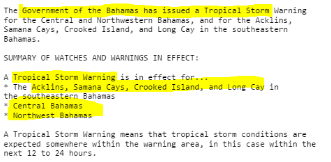
Biggest news is warnings edge deeper into the Bahamas...
...as TD12 is moving WNW still..
A Tropical Storm Warning is in effect for...* Central Bahamas* Northwestern Bahamas

Compare with last night ....
TD 12 cruising up the back bone of the Bahamas.
Would think we all the ship reports in that region...
...they would have more information.
NRL has nice imagery.

But....they are waiting on recon and visible imagery?
Funktop shows what image above shows.
Strong cells in there.


Technically still a TD.
12 systems in a "slow" year.
Not so slow... not a bumper crop year.
Strongly average if you ask me.
Tropical Depression 12 formed in the Bahamas last night.
Early model out put curves it out to sea.

There's a strong cold front pushing down and taking Kate out to sea.
TD 12 should be Tropical Kate soon enough.
Not Hurricane Kate... Tropical Storm Kate.
Last night's discussion was a bit confusing.
Only because it talks on the low shear environment and warm water.
Yet doesn't explain why they expect it not to be more than 50 MPH.
But with the movement more to the West it does bring it over warmer water.
Note models do not forecast that so logically speaking...
Catches the cold front and moves away from a US landfall.

I understand why we aren't expecting this to be Joaquin.
However the discussion doesn't really explain it.
Note it's a SMALL system and small systems...
...go up and down fast in intensity.
Due to be absorbed by other features.
I don't think the water is all that warm.
Will see tomorrow what it looks like in 1st good morning visible..
Recon is going in as well to figure out the intensity question
Also a little surprised the spoke of the Dvorak.
Personally I didn't think she looks that good on Dvorak.

Again remember small systems flare up fast.
And, go poof fast. Then flare up again.
Let's see what it's like in the morning light.
Official cone.

Note the blue colors in Bahamas...
Wind probs show San Salvador in it.. as a few places are...
Worth reminding you that these are the same places in recovery from Joaquin.
Even moderately strong weather is a set back.
Note earlier I mentioned Jim Williams had San Salvador up on his count down.
Compare and contrast with this morning.
Grand Bahamas was suddenly added into the mix when TD12 Edged West.
This morning.

Last night not there before it turned WNW.
Will turn NE eventually.

Let's look at some loops.

Mike on www.spaghettimodels.com has a variety of loops.
I'm not super impressed with the cold front for one..
Moved thru today and backing up tomorrow.
Small cyclone remember that.

You can see the drama here.
Pushed NW by the big bad high behind it.
The front approaches and wants to grab it and take it NE.
I wouldn't call this the best environment.
Worth remembering originally this wasn't supposed to form yet.
It's moving fast ahead of the original schedule.
November.
There is the smallest wrinkle tonight in the forecast.
One model breaks with the pack and brings it near Cane strength.

All take it away from the US and out to sea.
And a bit of a warning with this particular cyclone ;)
Be careful what you put into search parameters.
Put in "models Kate" and you get this....

Kate. Let's wait and see if it's Kate in the morning light.
I've drawn a few blue arrows onto Spaghetti Models.
1. Note there are already lots of warnings off shore currently.
2. Note the rain that is moving N with the front..hmnn.

Let's look at a loop that shows this better.
It's not going out to sea just yet.
Eventually but everything is timing with November cyclones.

Tonight it's not much to worry on ...
...unless you live in the part of the Bahamas already devastated from Joaquin..
After the low pressure region moves NE along the coast..
A high pressure is supposed to dig in....
Nice.. haven't see blue skies and sunshine for days in Carolina.
Bring it on!
Take it out to sea!
Let me see...
Good link to use to view Bahamas weather conditions.
Good in general ..
http://www.hurricanecity.com/cams/bahamascams.htm
I'll be back with more info after we see morning light and . . .
. . . get that recon data in to see just what is going on with TD 12...
Otherwise known as Tropical Storm Kate.
Besos BobbiStorm
@bobbistorm on Twitter
Ps I was gonna go to sleep early.
Yet here I am writing about Kate....
As sure as your name's Kate you put me here...
posted by BobbiStorm @ 7:54 PM
![]()


1 Comments:
Great Blog
Post a Comment
<< Home