Hype Happening on Coastal Low Forming and IF Danny is in the wind... Tropics Take Staycations This Summer SE Coast
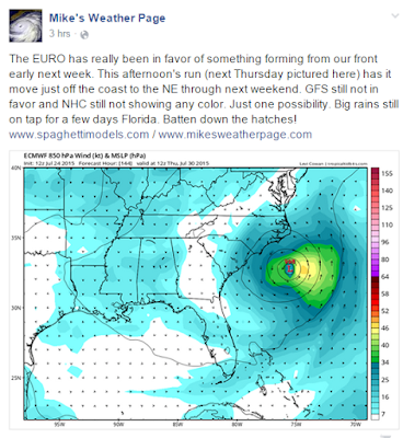
Still watching the area off the SE Coastline to see if consistent rainfall will favor pressure drops and if a low pressure center will form. There is some model support, though some are still standoffish. The NHC has yet to blink. It's close in and therefore an excellent candidate for this Staycation year that the Hurricanes are all doing so far.
As the discussion said earlier today, the area is drifting South and will merge with a stalled out cold front. When push comes to shove and steering currents collapse things sometimes start to spin.
Join in the discussion on Facebook.
https://www.facebook.com/TropicalUpdates?fref=ts
Post your thoughts, read other's thoughts.
We are all watching.
Most of tropical tracking is watching, waiting . . .
Watch this loop and if you see color converge off Carolina.
...or Georgia... or Jacksonville...
And you see a spin, something is happening.
The NWS 7 Day Loop has a Low moving up and down.
Sort of anchors itself on and off shore Florida.
http://www.wpc.ncep.noaa.gov/basicwx/day0-7loop.html
Sunday
Talk on stationary movement ...
Thursday it's trying still...
Pattern seems kind of stuck.
But, that can change.
There's a wave off of Africa.
SAL waiting for it...
And, convection off of the Carolinas.
Florida is messy.
Tomorrow should be a rainy mix over most of Florida.
But, it's summer down here and we are used to it.

Organized activity...
That is the real point here.
Lot's of sites are hyping the possibilities.
But, for now all we have is possibilities...
....and rain....
Noticed the winds picking up off and on down here today.
There's a big difference between RAIN
and.......
Tropical Storm Rain.
Named Rain.
Danny Rain.
Keep watching.
Besos Bobbi


0 Comments:
Post a Comment
<< Home