NOAA Weighs In 2015 Forecast. Atlantic Funky Looking. Keep Watching the GOM...
The "OFFICIAL" 2015 Forecast is in...

(sort of wide berth there... 6 to 11... hummmm)
Compare and contrast NOAA to other forecasts

NCSU goes with 1 Major Hurricane.
Personally I'd guess 2 and we are all guessing
CSU goes out on the ledge with exact numbers.
Why are they forecasting a slow season?
If you have been on Mars you probably missed...
..........all the talk on El Nino..........

I circled it for you in RED.
It's definitely there.
Again like Hurricane Seasons
No two El Ninos are they same.
They are all different like Cabbage Patch Dolls.

The fly in the ointment?
That fly may be in Africa...
Early waves are nicely spaced.
Larry Cosgrove, a good meteorologist, pointed this out...
with this graphic below in his weekly discussion

https://twitter.com/larrycosgrove
Sometimes it's the small details that go unnoticed.
Also......
Years with continual fronts dipping down into the GOM
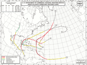
Note 1997 a very typical EL NINO year

http://www.nhc.noaa.gov/data/tcr/AL051997_Danny.pdf

3 points to remember:
1. Usually seasons that start early before the gun has been fired.. are typical of slow seasons. While this may be a slow season, it is not for the same reason.
2. Note the way that Danny formed out of an old cold front. Happens often. And, hurricanes that form close in are often more trouble than they are worth statistically as there is little lead time to warn anyone and as they are landlocked they are going to make landfall. With the set up we have had this year with the flow from the GOM moving, oozing north towards Houston, Nola and the Big Bend of Florida I would worry...
3. Things change in real time with weather and even a short term change can create the right ingredients for that "one hurricane" we will never forget........

With that tropical fetch already in place ...
...there could be trouble close in
And, lastly never forget it only takes one..
The "ONLY TAKES ONE" example:
1992

Map below . . .

A bunch of wishy washy Atlantic storms
and then........
ANDREW

Bulls eye Miami
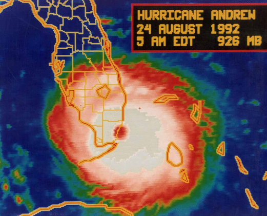
A Hurricane to Remember...
Also remember some cities ..
...like Tampa...
...are more prone to be hit in "quiet" years
Let's go now to the current State of the Tropics..

Is this an optical illusion you're wondering?
Looks like a Hurricane forming that is...
...bigger than the State of Florida
Hmnnn
NOAA has it up as a purple area of interest.
sort of pre-yellow on the NHC map

http://www.ssd.noaa.gov/PS/TROP/TCFP/atlantic.html
Just so you know I am not making this up...
I'm showing the compare and contrast
Real Time VS Climo
Why?
It's a bit curious to have so much activity this early...
...tho to be honest talking quasi tropical
...but still it's there on the map...
There is a small window for some kind of development.
To look for discussion of the official kind it's best to go to the source and that source is of course the NHC. In their tropical marine discussion they mention it as an "upper to mid-level low" and why that is of interest is it has worked it's way down to the "Mid-Level" already. Could it work it's way down to the Lower Levels that we care about ... being a "surface" feature? Doubtful, but it's possible and would never say never when it comes to this 2015 Atlantic Hurricane Season.

So... as we work on our Hurricane Preparation for this coming season we are keeping an eye to the East of Florida "just in case" something grabs it's small window for development and shows up as an Invest at the NRL site. There has been some talk... but for now it's only talk and talk is cheap.
I'll tell you one thing I do find curious is the cluster of strong storms blowing off Gulf Coast states into the Gulf of Mexico. In typically "quiet years" we get strange named storms like Danny in 1997 from these sort of set ups. Something to watch off and on when strong weather is there... Again remember how fast that storm blew up by Dauphin Island and how fast weather turned wicked in Houston from this same system.

Besos Bobbi
Ps http://www.nhc.noaa.gov/prepare/ Now is the time to prepare as there is no reasoning with Hurricane Season.
posted by BobbiStorm @ 10:50 AM
![]()


0 Comments:
Post a Comment
<< Home