Cape Verde Islands Wave - - 10% Yellow Circle
About time.

Part of the problem currently is that unless a model shows a storm forming and developing deeply the area of interest is ignored. It reminds me of when we were all online in chat rooms. If a wave was beginning to develop enough to get an Invest and then models were run and it showed the storm was either going to fall apart or recurve and immediately no forecaster, tracker or chaser wanted to talk about it anymore. If it's not going the distance... it's ignored.
That's now the current mind set it seems. If it's not going to do much... it's ignored. Unless of course it's about to hit Mexico and then suddenly it's upgraded two hours before landfall.
Yeah, it annoys me. I like consistency and there has been little from my perspective over the last ten years or so at the NHC. Without consistency how do you compare the data from year to year. It's easy to argue that now that we have better satellite surveillance than we used to have we can see when a circulation has formed or hasn't. Yes and no. It's true to some extent, but there are many storms in the last few years that would never have ben upgraded by either Bob Sheets or Max Mayfield.
I respect what they do enourmously... I'd just like a bit more consistency.
We live and die by the mdoels these days, but often the models are off for some reason hard to figure out until post season analysis.
The area is there...it has convection and spin and it deserves a yellow circle and possibly a NRL Invest down the road. We spent a week staring at nothing named 92L because the models were slow to drop it.
I like brain power and savy of forecasters who have experience to blend their own wisdom with the wonderful models to give us a better picture of what may or may not happen in the next two weeks.
I'm a little spoiled. I've known some incredible forecasters personally and they didn't have to wait for 2 or 3 days of modeling packages to follow a certain path before telling me that a wave off of Africa was going to recurve or slam into Wilmington, North Carolina.
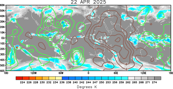
Currently we are all talking about the MJO moving into our part of the Atlantic Basin. It should do for the Atlantic what it did for the Pacific.
http://www.cpc.ncep.noaa.gov/products/precip/CWlink/ir_anim_monthly.shtml
Your homework is to study the link above and remember it for the next few days. Watch the green lines not the brown ones ;)

If a high forms a loft somewhere or an Upper Level Low decides to take a hike or a sabbatical...something somewhere will spin up soon.

1950 was a slow starting season. The first storms formed in August. No early May or June storms. An active busy year later in the season.

Let's look at the K storm... K for King.

Three Category 3s
Two Category 4s
One Category 5
Just because we don't have a Larbor Day Hurricane this weekend (Thank God) don't think the season is over!
I've been worried for months about an active October for South Florida and mentioned it here before. Strong frontal boundaries will suck anything up towards Florida.
So...keep watching the tropics.... and keep watching those models...they will start changing.
Meanwhile I am sort of finally unpacked. Finally settling in. I was over at the college tonight with my daughter who is there and my daughter who just came down from New York to visit.
This is Our State. This is Your State. Go Pack!
(I spent a lot of money for orientation to learn that ....)

This is Our State... we are the Wolf Pack....... lol. It's sort of like mind control. Nice to be back home.
Every state is going to have a great Labor Day Weekend including the beaches so make your plans, pick your beach and enjoy the quiet times.
Sweet Tropical Dreams,
BobbiStorm


0 Comments:
Post a Comment
<< Home