Hurricane Michael Forms & Hurricane Leslie Grows In the Atlantic.. Bermuda on her mind...
She's turning out to be a beautiful storm. She's turning out to be a beautiful Hurricane.
I was at the beach today... watching waves crash onto the shore with an intensity that screams "Hurricane out there somewhere" as people lined the beach to watch... only a brave or foolish few went into the water to their knees. Knee high became chest high fast, even ankle high became waist high when a strong wave crashed. I know ... trust me. Last night the waves were hitting hard, this morning they had a toughness to them... by later in the day they were crashing fast, time between the waves short and the ocean had the look of swells... vs just strong waves.
I spoke to several people who had come down for a few days and were disappointed to be swimming in the ocean front pool vs in the ocean. On Monday they took the toddles into the water, sat by the sand and had a nice day. Yesterday the waves were coming in so high they formed a tidal pool and it soon became too difficult for the children. Life guards rescued three sets of people before asking people to stay out of the water. That is how it was told to me..but several people. This morning they didn't even walk down to the beach, they watched from their balcony and resigned themselves to swimming in the pool. Well, the wife resigned herself as she was sunbathing, the husband came to swim in the ocean.. he was not a happy camper. She said she had never seen a tidal pool form there and though it was nice ...it seemed scary, different...not the way she's used to the water being.
Hot, windy and wild.
We drove back along the beach late yesterday working out way down from Delaware to Maryland. The waves are strong up and down the beach, some beaches worst than others depending on the particular beach, ocean floor and design of the particular beach. Moving down to North Carolina where waves are always strong on the Outer Banks, these waves today were stronger...different. You could tell there was a Hurricane out there somewhere.
The funny part is that later in the day when I stood mesmerized by the pounding surf, sea foam blowing on the beach, sandpipers in hiding and very few pelicans soaring I had a random thought "maybe she got stronger" and laughed it off. I left the phone inside so I could enjoy the surf without taking the chance that the camera was going to end up in the water and being dragged out to sea. Did I mention the strong riptides? After I took a shower, changed and checked my mail ...that was when I found out she had become a Hurricane. I smiled. I also read that her west side had grown by 100 nautical miles. It was not an illusion that something had changed... though in reality the waves had been traveling a long way and it shouldn't have made a difference. But, I've grown up at the beach and I've seen that before. You can tell something has changed...
As for Hurricane Leslie and where she is going...she is going to Bermuda as are a a lot of storm chasers who are already talking on Twitter as to which restaurants are the best to stop by and which stay open late for storm chasers. I've never been to Bermuda.. if I had a bucket list I'd add it there but rather not think on Bucket Lists and truth is Key West is my list and leaves very little room for any other beaches. Tybee... is nice. Myrtle Beach is fun and an illusion that I am home in Miami Beach. Beginning to love Kill Devil Hills after the tourist have left, of course....
She is forecast to intensify to a Category 2 Hurricane. After Bermuda she may move very close to Maine and very close to Cape Sable and all those other North Atlantic Ports of Call.

Check out the wind probs put out by the NHC at 11 pm Wednesday Night...
http://www.nhc.noaa.gov/text/refresh/MIAPWSAT2+shtml/060240.shtml?
Despite a ragged appearance and upwelling beginning to occur, lowering the water temps where Leslie is spinning out there ... the models STILL forecast her to become a stronger hurricane. Time will tell on that one... in ways she looks better, in ways she looks weaker. She is HUGE, big and dangerous and at the moment...headed very, very, very slowly towards Bermuda.
THE MOTION IS ESTIMATED TO BE
010/2 KT.  LESLIE SHOULD CONTINUE A SLOW NORTHWARD CREEP FOR THE
NEXT 48 HOURS OR SO WHILE IT REMAINS TRAPPED TO THE SOUTH OF A
MID-LEVEL HIGH CENTERED TO THE NORTHEAST OF BERMUDA.
She might stay off shore, but her weather will be felt over a very wide area as the map above shows. If she moves more to the left there is a chance that Cape Cod may have to deal with Hurricane Leslie, but that is a long shot I think though not really sure enough to say not to worry.
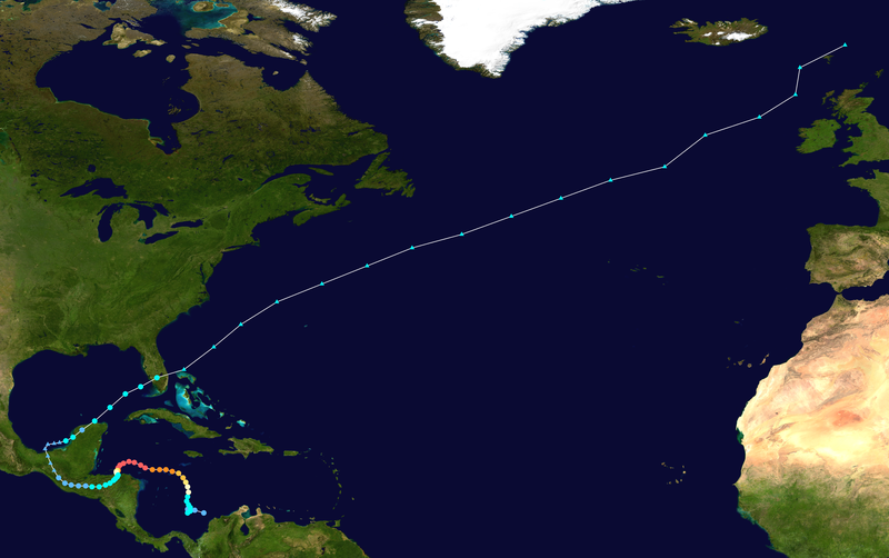
Further out in the Atlantic... Michael has been upgraded to Hurricane.
There is a random, but possible, chance that he may hook up with Leslie and hook out to sea fast ... time will tell.
You can see the large outflow of Hurricane Leslie off to her west...
And, in the Gulf of Mexico there is a new "Invest" named 90 that they are watching. It has a 50% chance of development, and they may send planes into it tomorrow. It is part of the large circulation that was Isaac. If you remember Isaac had a very large tail and several small areas of convection within the broader circulation and this dislodged remnant has traveled back into the Gulf. Whether it would be called Isaac or most likely Nadine. But, it has a long way to go before getting a name.
The models take her mostly east across Florida. Oddly enough, one model takes it towards Tampa as if there is some genetic memory for Isaac's remnants to want to hit Tampa. It most likely would be pulled east across North Florida as either a lot of rain or a named storm or designated depression.
Another view...
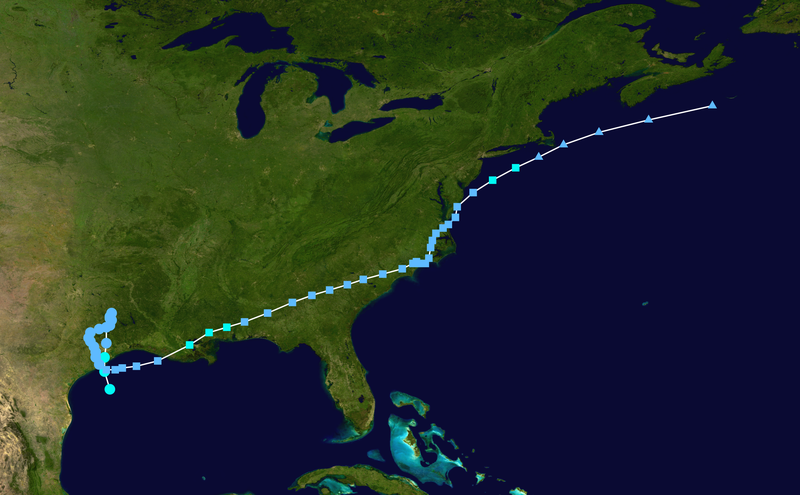
Oddly this reminds me of Tropical Storm Allison ...which I have used as a similar storm to Isaac.
Look how similar the track of Allison was to the models above.. the little dip back into the Gulf.

Hey... it happens.
Could it happen?
The Mimic loop shows a real sense of energy coming together in the Gulf...
It also shows a pool of cool water that it will have to contend with...
the link is on www.spaghettimodels.com
one of many...
See the small pool of blue water that hooks around into the gulf briefly and then disappears ..
Also, notice how there are oranges off the coast of the Outer Banks up to NY and NE...
Another great link to loop that shows the whole story:
In 1997 the remnants of Danny reformed and as they made "seafall" in the Atlantic advisories were issued again.............though that was the actual circulation center in theory

A year later in 1998 Hurricane Mitch, another storm I compared Isaac to in size
reformed after spending DAYS on Central America and dumping tons of rain
traveling through Mexico and making it intact...sort of ...back to water
the NHC went ahead and kept the name Mitch and tracked it towards South Florida
Note there was discussion on using the N name...but they stuck with Mitch.

Strange things do happen in the tropics...

So there we have it at 11 PM... 2 Hurricanes and a big Question Mark in the Gulf.
The main news at 11 PM is this... Michael is now a Hurricane as a small eye popped out on satellite imagery a little while earlier.
![[Image of 3-day forecast and coastal areas under a warning or a watch]](http://www.nhc.noaa.gov/storm_graphics/AT13/refresh/AL1312W_NL_sm2+gif/024051W_NL_sm.gif)
Hurricane Michael moving slowly like Leslie... weak steering currents......
If you live near a beach on the East Coast anywhere from Miami to Maine, enjoy but be safe, be careful and obey all rules and watch from the sand... do not go into the water. She may be very far off shore, headed to Bermuda, but her effects can be felt with high surf, dangerous rip tides and strong waves.
More tomorrow...
Sweet Tropical Dreams
Ps Bobbi
Ps... The start of the NFL Football Season began this evening... let the games begin ;)


0 Comments:
Post a Comment
<< Home