Updated! 10 PM Nicole .. Subtropical ? Tropical? Like a Hybrid? It's Nicole and It's Headed to Florida. Then Coastal Cruiser. Storm Surge, Coastal Erosion. A Mess. A Huge Mess
10 PM New Cone.
MostlyOld Cone.
NHC tries they really do.

Time of arrival of winds.
The Day After Tomorrow..........
The morning after the election.
Eclipse early this morning, before dawn.
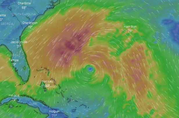
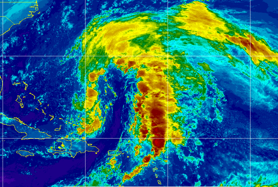
Nicole really shows up on Earthnull.
Finally perfectly round......

Now all it has to do is wrap up.
Wind impacts.
Rain, weather also Windy.com EURO tonight.
NAM above and below comes in low.

That's it.
I'll say NHC Discussion tonight...

Uncertainty in intensity.
Dry Air at Mid Levels.
Enhanced Pressure Gradient!
It's coming..........whatever it is.
One thing we know for sure.
It's name is Nicole!
Night everyone... enjoy the night music
Leaving this here....
Dabuh sent me the song ;)
Love this song. Enjoy....

New cone on the right.
Note the center track deeper inland.
That can change.
It all can change.
Hot and humid in NC today. 84 degrees.
Should cool off soon.

Visible imagery shows where a center could wrap around.
But for now the weather is across a wide area.
Meaning still Subtropical.

Another sat view of the above image.
Like half a storm.
BUT
This is the whole Nicole.

It's not your Momma's storm.
I've seen Subtropicals that look more organized.
That said.......it's forecast to pull together.
I'll update after this evening's model runs.

NHC shows the center above.
Yes the old Invest is still there......
I'll update later.
Watching it carefully and it just has so many moving parts.
Follow NHC
Find your local NWS
I put this on Twitter...
..because it's like Nicole has a cloaking device.
And when it shows it's face.
It may be too late for you to prepare.
So follow advice from NHC, please.
Abit of levity.
It's a serious situation for those who will see Nicole.
Do what you got to do!
Please keep reading.
Yes, still owe ya a song.
NAM still showing the same thing.


I'm using NAM as this is all weather.
It's not tropical and weather is weather.
A good close in measure.
Wednesday.
Day After Tomorrow!
* * *
11 AM
NAM model for Nicole.
something other than the EURO and GFS
NAM is short range.

Onslaught of strong winds on coast Tueday.
Across a wide area.
Wednesday, day after the election.

Tightens up into a Tropical System.
Wind, rain shown here.
Very far South.
Tricky forecast!
NHC Cone below!

Nicole makes tango moves.
Dips down, then up again!
NHC doing 11 AM at 10 AM bc time change.
Remember that.
5 PM will be at 4 PM
Don't ask why just remember.
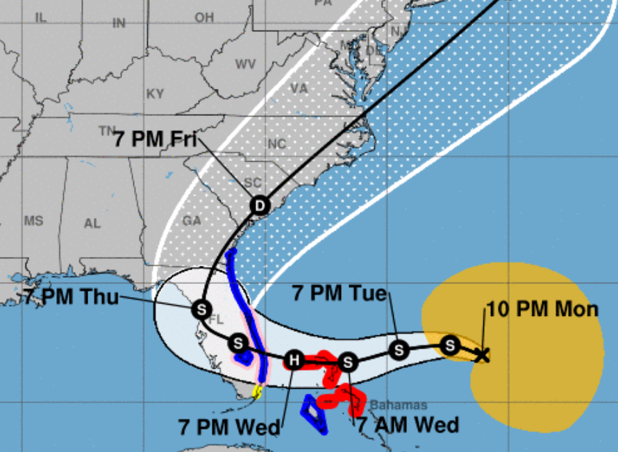
The pink shaded area is a Hurricane Watch, the yellow on either side of it is Tropical Storm Watch meaning Jax and Miami get TS watches and everything else gets Hurricane Watches. At some point these watches will be upgraded to Hurricane Warning as our Subtropical storm goes Tropical and is forecast to be a minimal Hurricane. Again everything I type is meant to be taken as "current situation" and subject to change as nothing is set in stone as we learned from Ian and especially with quirky November Hurricanes!
Prepare for what is posted and keep in mind you could get more than expected so plan and prepare accordingly!
Do not follow the center of the line, learn from Ian that can change and it's still 2022 so it probably will!

A large area impacted by wild weather.

Breaking this down in parts.
This area will get weather from Nicole going and coming.
Because of the odd nature of Nicole this is very important. Beginning late Monday winds will increase along this coastline, Tuesday into Wednesday surf will be high, beach erosion can occur WAY BEFORE Nicole visits this same area on it's way back out into the Atlantic AFTER doing Florida so places such as Daytona, Jax, Sav and SC/NC coastline get a double dose of weather from Nicole. This is akin to being hit by a vehicle and then it backs up over you, not a pretty analogy and not pretty in real life either. So if you live in this neck of the woods below know you can see Nicole, coming and going. And, structures on the beach that are greatly weakened by the battering of onshore winds from Nicole far offshore may topple and fall into the ocean on it's way out when the winds impact the same beaches from the back side.
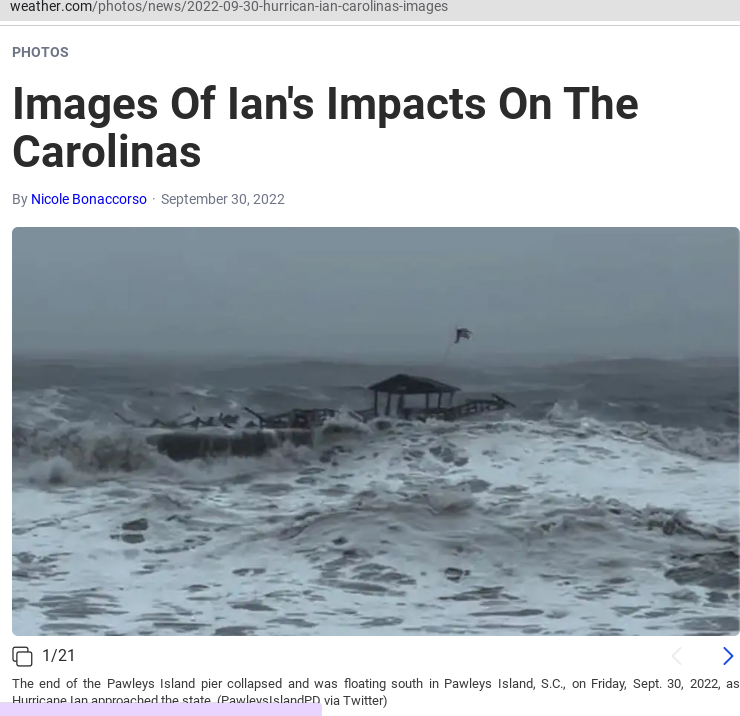
If y'all remember the story of the pier on Pawley's Island SC "last seen floating South" you will understand that not only is Nicole possibly retracing some of Ian's spots devastated on Florida's West Coast but also pounding the area in South Carolina that was slammed by Ian on it's way out. Late season storms (both Ian and Nicole) take this sort of track after being picked up by a strong front.


Impacts along NC NOW currently.
From onshore strong flow.
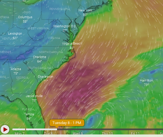
NAM for Tuesday!
Same places could be in the Cone later.

Charleston!!
You get the idea.
Today...not later on it's exit out.
Naples FL near FMB
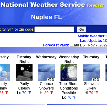
Tropical Storm conditions likely Wednesday Night.
Lastly... listen up I'll say it again. The DETAILS will change, they always do ESPECIALLY when a Subtropical Storm TRANSITIONS to a Tropical Storm/Hurricane so check back with the NHC, your local NWS, your favorite on air mets and those of us who you trust online like they are your best friend.
Don't let some city get surprised and shocked by the intensity of Hurricane Nicole because you were sure it was going to hit Tampa or Naples .... or Port St. Lucie not Ft. Lauderdale or well you get the idea. Nothing is set in stone other than we have a developing subtropical storm that is forecast to become a Hurricane and make landfall somewhere in Florida.
Tuesday in an Eclipse and weather traditionally wratches up a notch during eclipses especially the tides which are always higher so Nicole is coming at a worst possible time.
Tuesday is election day in a country very obsessed with this election and this is not a political comment but a psychological one as many can be distracted by the election, the news, the day after and not be paying close attention to a storm someone said was something called Subtropical and the line in the cone was far from their house and that person won't see Nicole coming as their focus will be on the election. That said, go vote if you have not and am thinking those who voted early will be glad they did along the SE coastal cities and in Florida.
Stay tuned. I'll update this afternoon after the 5 PM that'll be at 4 PM because the NHC says so :)
Unless something huge changes.
Current Models.

Bottom line:
Ppl ask what I think.......
I think pay attn for real time changes in forecast!
Also...depending where Nicole does landfall...
...if to the S won't fall apart much over marsh.
So W FL could get a bad hit.
Hope not.
Just reminding you.
Track further N it could weaken more.
I'll find a song later but here's good video from Ian.
In SC a place now about to get wind/surf from Nicole.
Before it does Florida and then on it's way out again!
Daytona Beach below.
Nicole gonna do it again it looks like
Keep reading if you missed the basics this morning.
Thanks
Subtropical Storm Nicole.
Note Weather across a wide area...
..vs a tight center.
Good call by the NHC.
Details and cone below.

Subtropical Storms, simply put, are similar to tropical storms and most importantly contain winds of Tropical Storm force around a broader circulation that often later tightens up over warmer water and develops TS characteristics and can often become Hurricanes.

Note this IS forecast to be Tropical Storm .
It likely could also be a Hurricane.

Models from NC....
..also watching Nicole.

45 MPH going to make a snake like track across FL.
And, yes it could cross Florida.
Then get pulled back by a front.
The stronger front.
This is basically a quick update to let you know that Nicole is on the map and the clock is counting.
At a time such as this you read forecast discussion for Melbourne Florida, as it's in the track and always one of the best NWS discussions to read anywhere. They lead with the dangers, the concerns and discuss the details. Curently, NWS Miami, hasn't updated their long term discussion but they will. The secret to this storm is to go to the NWS closest to you and put in "my town NWS forecast discussion" and read it, it's usually easy enough to read if you've been reading my blog and that is basically what your local on air meteorologists uses to tell you what you are going to be seeing from Nicole. Go straight to the source, go to the NWS website as well as the NHC website!
This is as good as it gets today.

Dangerous Seas
Building Surf
Strong Rip Currents
Beach Erosion
Dune Breaching
Coastal Flooding
Increasing Winds
Gusty Squalls
Heavy Rainfall Totals.
Every city in it's large elephant like trunk has a similar but different forecast. I'm concerned on Charleston and it's adjacent beach communities North and South of that beautiful city as they were pounded by Ian and are still cleaning up some. Speaking of Ian, yes unless something changes, it could also rain on the West Coast and bring more tropical winds to an area that is still picking through the debris. The "Treasure Coast" of Florida was banged up bad by Ian and you didn't see much on that on the news, so a direct hit there will be not quite devastating but stonger than you probably think. Note it's called the TREASURE COAST from treasure that would wash up on it's beaches from many similar storms to Nicole.
Yes, I'm concerned on Miami to WPB as nothing is really set in stone as I often say. It's just been named and it has not tightened up much into a real entity but it is packing 45 MPH winds. As for the Carolina coast and parts of VA they will see a nonstop onshore flow from the NE that will deliver a larger impact that you'd think but that's the nature of the beast. And, I'm talking about when it's on it's way to developing, then after it does whatever it does in Florida, it gets pulled BACK up over Georgia, the Carolinas and VA to wallop them again on it's way up the coast.
An impact late season storm similar to many that have happened over history and indeed have taken down many a schooner, galleon that didn't get updates on Apps or Cones from the NHC.
Many La Nina Hurricane Seasons have a punctuation point at the end with a nasty surprise.

Snake like tracks in November are common.
Eta in 2020 did a similar snaking path across Florida. This is not as rare as many would say, but often they were just simply written up as Gale Centers or some other language but the NHC (rightly so) began naming Subtropical Storms that sometimes stay subtropical and often can end up Hurricanes before merging into a front and getting another meteorological name.
The name for this one is Nicole.
Ending here for now with what I put up on Twitter to remind people after Ian hit a beach people thought would see it cruise by on it's way elsewhere.

Nothing is set in stone!
But follow the NHC cone!!
It'll change in real time if needed.
It's your job to watch for any changes.
I'll update later.
This was an introduction to Nicole.
Be back later this morning.
I'll add a song in then and...
posted by BobbiStorm @ 5:41 AM
![]()


0 Comments:
Post a Comment
<< Home