Updated!! INVESTS 96L 97L Will They Impact Islands? GOM? FL? Stay Tuned...
Track at 8 PM for Invests is an extrapolation of 2PM below.
Going to share an online friend's blog.
Good thoughts.
We all have good thoughts.
We tell the story a little different.
By reading may we always learn something.
Good graphic.
http://www.conweather.com/blog/the-tropics
Truth is an Invest is potential.
If the tropical wave didn't have potential.
It would just be a tropical wave.
The NHC tags them as such when they see potential.
So keep watching.
And, yes the track stays below Florida.
But as anyone in Florida knows.
When a system is to the South of you...
..never take your eyes off of it!
Please keep reading if you have not done so.
The thoughts expressed earlier are still valid.
Sweet Tropical Dreams.
BobbiStorm
@Bobbistorm on Twitter.
2PM
40% Invest 96L
30% Invest 97L
Suddenly many things from nothing.
As I've said many times...
...things change fast in the Tropics.
Keeping in mind this is late July.
Trying to keep the hype way low.
Staying logical but amused.
Let's look at the together and then separately.
There they are side by side.
Note 97L is a bit higher up than 96L
Remembering 96L just leaving African Coast.
97L seems to be moving at a fast clip.
Yesterday it was just one large messy area.
Easy to see that the Islands really need rain.
They do that's true.
Rain vs a Hurricane.
As I said earlier this is the Waves VS SAL
I'm sure Cantore is watching.
His travel agenda may be calling.
Recon will go in tomorrow if needed.
Meaning if it warrants.
This IS what Tropical Weather is all about.
One day nada, nothing having for the next 5 days.
12 hours or so later and there are twin Invests headed West.
Models currently show a colorful spread.
All basically the same..kind of.
97L is on top as it's most important for most of us..
96L below... westbound or fish storm.
As I said this morning once they get past 60 West..
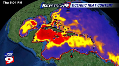
Water gets warmer.
Caribbean is hot, hot, hot.
HOT!
Earl in the Caribbean would be a bull in a china shop.
Messy, lots of broken things.
Up over the islands might be better.
Though again the Bahamas are warm and waiting.
97L
Levi Cowan's Tropical Tidbits Models.
Sticking with 97L as it's sort of in our face right now.
On Friday there is a double barreled High over South Florida
Note it shows rain despite the High Pressure.
A few days later...
And then........oddly the High backs up a bit.
Note it just shows a L
For Low...
That's as much as we know... for sure.
So stay tuned and check back often.
I'll be updating later this evening after the 8 PM.
And update the thoughts.
Yes it doesn't look like it's aiming at South Florida.
It also is aiming at Islands, Cuba, Carib, Bahamas..
And then there's Invest 96L
Invest 96L could be a problem.
A lot of intangibles.
IF these waves can develop.. either of them.
Despite the SAL and all that dry air...
I'd worry as we get into August and September.
Just reading Tweets online.
My thoughts exactly.
Putting this here in real time.
And... note today is the birthday of Miami.
Yes, that's a big deal.
So let's think about the ultimate September Remember storm..
The Great Miami Hurricane.
Long version:
Short version:
From Miami to Palm Beach...
One last thought for now.
Remember I've said this a few times.
Last week or two Upper Level Lows ....
...were in the Florida Straits westbound.
Wouldn't be a big shock to see a weak named system appear there.
Patterns.. upper air patterns.
Watch the patterns and keep your eye on the Invests.
Model discussion added in later tonight.
Seems like 97L has it's eyes on the Islands for now.
Now it can use some convection.
Warmer waters to the west.
And 97L in a rush to get to them.
Playing some Santana while packing for Miami.
Or as we Miamians call it MYAMI
Besos BobbiStorm
@bobbistorm on Twitter
Ps Updating later this evening.
Again a lot of talk on that Heat Dome.
Extreme Heat is often broken by tropical systems.
But that's down the tropical road...
Stay tuned...
Hoping 2016 isn't a redo of the 2012 Hurricane Season..


0 Comments:
Post a Comment
<< Home