ALL ABOUT RITA on TWC ...Tampa Bay 1921 Hurricane ...Today Just Cold Fronts & Swirls....Area Near Florida in Eastern Gulf
The Weather Channel is singing the song of Rita today. A good lesson on when to evacuate and when not to evacuate. Like the song goes...got to know when to hold em.. when to fold em... when to pick up and go and when to stay.
Way too many people took to the roads in shear panic...

Remember this year people took to the road to try and out run a tornado and people will kill sitting ducks in that traffic jam. A different problem... but it came to mind as did the 3 men who died caught in that traffic jam rather than out doing their job gathering information in the Twister...
Rita's forecasted track is shone below:

Nothing like that going in this year in the Gulf of Mexico.. just swirls and Ex-Invests.
What's happening TODAY in the Tropics? Not a lot.
First I look at the Visible Image to answer any visible questions I may have..

Yes there IS a SWIRL in the Gulf of Mexico. But, it's just a swirl. Interestingly there's something going on in the Eastern Gulf of Mexico. Might just be WEATHER but it's really WEATHER..

This image should update so as of Noon on Monday there is a dark spot of moisture in the Ex Invest Swirl and a blob moving in towards Tampa Bay...

Another view... note the wave trying to make it across the Atlantic..

Close up on Radar South Florida is getting RAIN today.. again...
On TWC they are talking about the old Ex-Invest 95 .... the Invest that got away like their old Invest 92...
Ex-Invest... can't remember when we discussed "Ex-Invests" on TWC. It's like having a deep conversation about some girl you knew in Middle School who you composed a note to in History class telling her how cute her hair is and how smart she is and you love the way she smiles but you crumble up the note and never tell her and you are talking about it decades later... Seriously?? The "Ex-Invest" that is all we got to talk about??
They are struggling to say that the season isn't really over even though it seems the season is over. Things aren't always what they seem... TWC is doing Hurricane History. We did a lot of Hurricane History in 1997 when "The Mother of El Ninos" kept a strong grip on the tropics.
2013 is ending up a history lesson of the great storms of years past. Throughout September and into October there is ALWAYS a storm that is having an anniversary. Stay tuned... you'll learn a lot. Slow years are often followed by very active years. 1998 was a larger than life year in the tropics for instance.
1997

(note few of those storms are dark red or orange or hot pinkish-purple...most were very weak storms)
1998...check it out... Long trackers. Something changed. El Nino was GONE!!

(note a lot of strong, intense hurricanes)
1999 was also a year of strong, intense hurricanes.

The one thing about Hurricane History is that patterns repeat.
1931... relatively weak, weak year. Today people would complain the NHC was naming things just to name them. About as weak as it gets.

Yellow tracks are weak tracks. Only 3 storms showed themselves as hurricanes briefly.
1932 it warms up...

1933 it goes BONKERS

Final Note here...
Jim Williams from HurricaneCity.com fame is good at predicting what areas are more prone to being hit vs the normal "how many storms will we have?" and really isn't it more important to know WHERE they will hit vs HOW MANY?? This year has multiple storms traipsing around the Bay of Campeche..no one else really saw action ....
Some areas in the basin are more prone to be hit in "WEAK" "QUIET" years and that statement makes us remember it's not over until the end of October as the nursery rhyme goes. Can you imagine a weather oriented nursery school for those little tykes who LOVE maps and weather?? Wow, would I have LOVED that!
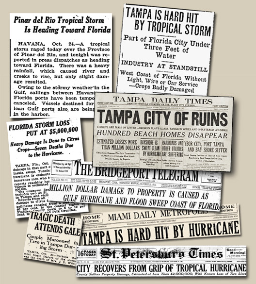
1921.. Tampa Bay Hurricane. Relatively quiet year...

Let's look at this carefully. Just before the BIG storm hit a smaller one came in further to the south... then the #6 Storm forms deep in the SW Carib and rides some cold front into the general Tampa Bay area with 140 MPH winds. The last time Tampa Bay had been hit like that was the Hurricane of 1848...
http://en.wikipedia.org/wiki/1921_Tampa_Bay_hurricane

In June there was a hurricane in the Gulf...then in early September a weak BOC system. Not a lot to write home about until there was...
And, even when winter comes on like gang busters there is this thing meteorologically known as Indian Summer. A week or so of warmer weather early in Autumn. Often the tropics get their last chance for a blast of tropical energy during those periods.
Keep 1921 in mind the rest of the season. Not because it WILL happen, but patterns show us that it COULD happen.
If I was TWC I'd be talking more about seasons with late storms that are similar to this year than replaying 2005 every chance they can just so they can show Hurricane footage from the Atlantic Basin during the Tropical Update.
What's happening today in the Gulf of Mexico (seems the Atlantic is dead according to those who believe they know...) ???
A frontal boundary is draped across the Gulf of Mexico..

If it stays there...

There is an area in the Gulf where something could develop. IF something gets into the Eastern Gulf of Mexico away from the DRY air in the NW part of the Gulf of Mexico something COULD form and there are fronts that would pick it up and catch it and take it inland somewhere.
Worth watching.. not like there's much else to watch tropically.
That's it for now... just something to think on and something to remember and right now I'd be remembering the Tampa Bay Hurricane of 1921 and not as much Rita.
Besos Bobbi

http://www.tampapix.com/hurricane.htm
Patterns repeat...
posted by BobbiStorm @ 9:50 AM
![]()


0 Comments:
Post a Comment
<< Home