Some visuals that are important to remember....
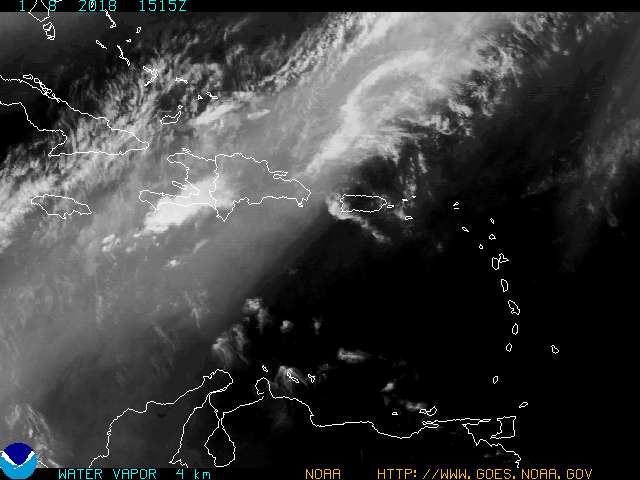
A rain band from Tropical Storm Leslie raining on Puerto Rico

This is real time so it will be gone in a little while... but PR did get rain from Leslie's outer bands.
.DISCUSSION...OUTER FRINGE BANDS ON THE SOUTHWEST SIDE OF
TROPICAL STORM LESLIE AFFECTED THE NORTHERN COASTAL WATERS MOST
OF THE DAY...BUT OTHERWISE CONVECTION WAS SLOW TO INITIATE
LOCALLY. HOWEVER...BETWEEN 130 AND 200 PM...SCATTERED SHOWERS AND
ISOLATED THUNDERSTORMS BEGAN TO DEVELOP AND INCREASE IN COVERAGE
ALONG THE CORDILLERA CENTRAL AND THEREFORE DECIDED TO LEAVE THE
COVERAGE OF LATE AFTERNOON/EARLY EVENING CONVECTION ALONE IN THE
GRIDS AND FORECASTS.
Remember the "center" of Tropical Storm Leslie DID stay well away from the islands. But, weather did affect the islands from the outer bands.
Discussion had previously given the impression that would not happen. Nothing is a "SURE THING" until you can look back at it in retrospect. Remember that.
Doesn't look like she's moved too much:
Tropical Storm LESLIE Forecast Discussion
000
WTNT42 KNHC 022047
TCDAT2

TROPICAL STORM LESLIE DISCUSSION NUMBER  14
NWS NATIONAL HURRICANE CENTER MIAMI FL       AL122012
500 PM AST SUN SEP 02 2012

THE OVERALL SATELLITE PRESENTATION OF LESLIE HAS CHANGED LITTLE
DURING THE DAY...AS THE CENTER REMAINS EXPOSED TO THE NORTHWEST OF
THE DEEP CONVECTION DUE TO MODERATE TO STRONG NORTHWESTERLY SHEAR.
AN ASCAT PASS THAT ARRIVED SHORTLY AFTER THE RELEASE OF THE
PREVIOUS ADVISORY SHOWED A LARGE AREA OF 40-45 KT WINDS WELL TO THE
NORTHEAST OF THE CENTER.  BASED ON ASCAT DATA...THE INTENSITY IS
REDUCED TO 50 KT.
|
|
According to the NHC... the presentation hasn't changed much either. Mind you, she did move... but not a far north as she did west ...however the NHC will say she is going NW. With a funky center and a naked swirl it is hard to argue ...or maybe it is... as the naked swirl is easier to track than a covered up clouded center. It's a moot point, because down the road she's not going to move much either..
What does change is her presentation on the Mimic loop, which is really pretty impressive.
Some things to remember..............
Storms caught in weak steering currents are not always predictable.
"
THE TROPICAL STORM SHOULD CONTINUE
NORTHWESTWARD TONIGHT...THEN TURN NORTHWARD IN 24-36 HOURS
AS IT MOVES TOWARD A BREAK IN THE SUBTROPICAL RIDGE.  AFTER THAT
TIME...LESLIE IS EXPECTED TO SLOW DOWN AS A MID-LEVEL RIDGE BUILDS
OVER THE WESTERN ATLANTIC.  THERE IS MORE SPREAD IN THE TRACK
GUIDANCE AFTER 48 HOURS THAN THERE WAS THIS MORNING.  THE ECMWF AND
GFS MODEL TRACKS ARE NOW SEVERAL HUNDRED MILES APART...WITH THE GFS
ALONG THE EAST SIDE OF THE GUIDANCE ENVELOPE...AND THE ECMWF THE
WESTERNMOST MODEL.  GIVEN THIS SPREAD...THE UPDATED TRACK IS
BETWEEN THE MULTI-MODEL CONSENSUS AND THE PREVIOUS NHC FORECAST.
BECAUSE OF THE INCREASED SPREAD...THERE IS A LITTLE LESS CONFIDENCE
IN THE TRACK FORECAST THAN BEFORE."
Discussion from the NHC shows that the models diverge greatly and they are going to split the middle putting the GFS on one end and the European on the other and drawn a cone around the middle... which is what they have done all season. Nothing new there either. They also admit they have less confidence in this track forecast than before..............
Translation: Pay attention... this is far from over.
Pretty much the same Ice Cream Cone as the last... with the flavor of the day being Chocolate Chip Indecision.
![[Image of 5-day forecast of predicted track, and coastal areas under a warning or a watch]](http://www.nhc.noaa.gov/storm_graphics/AT12/refresh/AL1212W5_sm2+gif/210007W_sm.gif)
Be back later.... notice the end of the cone leans to the left.... closer and closer to Bermuda.
Gonna have wild waves later this week on the East Coast.
Oh, and some models STILL intensify Leslie while she is spinning, stalled out over warm water later this week.
Time will tell.............so will Leslie


0 Comments:
Post a Comment
<< Home