My Concerns on Leslie..(already west of forecast)

My concern on Leslie is very simply put:
1. She is already west of the forecast points from several days ago. This has been a continuing trend, why would it not continue?
2. The intensity forecast has been way off and her moving further north and staying further East was partially based on her intensity forecast. A stronger storm catches the upper level winds and wants to go north. A weaker storm still pulls north, but wanders west further.
That can be seen by looking at old forecast cones and model out put images.
Notice these models had her further east and north than where she is today. One model came close, but even now she is further west than the outlying model that came close.
She is currently at:

LOCATION...21.3N 61.1W
ABOUT 295 MI...475 KM N OF THE LEEWARD ISLANDS
MAXIMUM SUSTAINED WINDS...65 MPH...100 KM/H
PRESENT MOVEMENT...NW OR 305 DEGREES AT 15 MPH...24 KM/H
Her convection is to the south of her naked center which is up around 21.3... if you look at her sat image you can see she is basically at 20n/60w.
It may seem like splitting hairs, but extrapolated over time that's a big difference. Note only one of the models had her where she is and it wasn't the GFS...MAXIMUM SUSTAINED WINDS ARE NEAR 35 MPH...55 KM/H...WITH HIGHER GUSTS. THE DEPRESSION IS EXPECTED TO BECOME A TROPICAL STORM LATER TODAY...AND COULD BECOME A HURRICANE OVER THE WEEKEND.Note they did say "could" which is not a forecast, but more a comment. Rather than intensify, she started to fall apart.Just a day ago they were off on their forecast:She is a drop to the west and south of the right side of the cone.This is a day ago.... that's a big difference.She ALWAYS rides the West side of the Cone..This is from Thursday.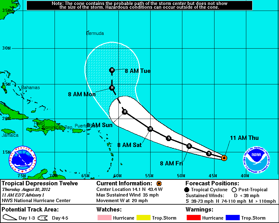
This can be a problem down the road.Look at the discussion on her forecast intensity from the other day:An old forecast shows they were conservatively (vs the models) forecasting her to be a Hurricane by now, 85 mph winds.http://www.nhc.noaa.gov/archive/2012/al12/al122012.discus.005.shtml?FORECAST POSITIONS AND MAX WINDS INIT 31/1500Z 16.2N 49.1W 55 KT 65 MPH 12H 01/0000Z 17.2N 51.3W 60 KT 70 MPH 24H 01/1200Z 18.5N 54.0W 65 KT 75 MPH 36H 02/0000Z 19.6N 56.3W 70 KT 80 MPH 48H 02/1200Z 20.9N 58.4W 75 KT 85 MPH 72H 03/1200Z 23.8N 61.3W 80 KT 90 MPHSo, my question is more for the models which can't talk and it's like talking to Mr. Ed.WHY were they so off?Some models forecast a Category 3 and 4 storm and not a weak, falling apart..naked storm.So, I would take the models with a big grain of salt at this point... be happy she is weak, watch her spin but know her bands slapped the Islands with a bunch of strong storms yesterday. That is probably why they were forecast at 34% chance of getting weather .. even though the forecast seemed to scream "fish storm up the middle of the Ocean" and she is not a fish storm yet.A bigger concern is from Carolina north and mostly......the Canadian Maritimes need to watch this storm very carefully. And, considering she is still forecast to sit and spin, creating high waves along the Florida/Carolina coastline...watching should be easy. She will be on the maps for a while....She may be moving NW, you can see her naked center moving NW but... she is gaining on the Westward movement still. Where she stalls, how far west she gets makes a big difference how she relates to the future steering currents down the road. The low that is forecast to form over Florida, the high to her east... the doorway away from land......etc.The upper level low to her WNW is beginning to form.
Understand why I am concerned?Whenever something does something it was not supposed to do then it is obvious we missed something or...the models missed something. On another hand, the ULL may ventilate her a bit more.Today's models....one shows her making a small, loop where she briefly lunges towards Florida and the loops back...The 11 AM discussion basically says that they had to drag the track westward based on the fact that her location is further westward than they expected ...THOUGH WITHIN THE CONE... etc, etc...Keep watching her, she's not following the plan right now.. maybe she will down the road, but let's call a spade a spade or however that old saying goes... she is west of where she was supposed to be.Besos BobbiPS...Bonus Loop and note she is closing in on 65W.


posted by BobbiStorm @ 11:18 AM
![]()


0 Comments:
Post a Comment
<< Home