TD 12 Forms!Gert Is Back! Joining Jose & Franklin Out in the Mid Atlantc. NEW WAVE OFF AFRICA.... Ppl Watching It. Can It Maike It Across the Atlantic?

Classic song for baby boomers.
Yes your parents played this game...
Moving on, looking at Sat Imagery

Idalia is NOT expected to loop all the way back to NE, I wouldn't say that's carved in stone but they are looking at for a good stone carver just in case. But I'd keep watching it just in case, models flip more than a pancake maker at IHOP. Most of the named storms are fairly meaningless, part of the overall messy steering currents for Franklin that sucked up all the energy and small tropical storms into it's orbit. Gert deserves an award for never giving up, got her designation back.

Until Idalia is moving EAST...
..we will keep watching models.
And watching Idalia.
Post Tropical Cyclone Idalia to be clear.
Not discussing Jose, being absorbed by Fanklin soon.
Tropical Depression Gert is foreast to be a TS again.

That's it.
But I felt after all that work deserved to be shown.

Franklin going extra tropical too.
Way up where storms below this year.
NATL season, will that change soon?

TD12 u know this script by heart.
Stay weak, downgraded quick.
A lot of One Hit Wonders this year.
Or maybe it turns WNW ...we will see.
It is related to Gert afterall

So here is out whole Atlantic Basin.
Zoom Earth tracks them all.
Great place to see it all at once.
Once a pattern is set in and you have strong storms in the North Atlantic, be it Franklin or Idalia both Extra Tropical they are still game changers for future small waves coming off and trying to make it across the Atlantic. If you have lived near a river... like the Miami River, you watch these small boats everywhere moving up the river and suddenly one big, beautiful speed boat that's all decked out with everything you can cram on a speed boat including women in bikinis lying on the deck sunbathing as it zips along faster than it's supposed to and if they get a ticket they'll just pay the ticket and post pics on Instagram anyway. All the little cute boats behind it start wobbling in the speed boat that looks more lkee a yacht's wake, some look like they might actually flip over but until that big beautiful speed boat moves on up the river with the boom box playing... they will wait it out and then sail along enjoying their day.
Big question............will the High rebuild back in and allow, no not allow but actually propell a strong Tropical Wave West allowing it to get all the way to the Islands and beyond. For all the talk on acction there haven't been any big Caribbean Storms (could change in late Sept or October if El Nino lets) and most of our ACE (Accumulated Cyclone Energy) is so far from Fankling in the NALT, DON that hung out there as well and Idalia going to hang out there. Time will tell.
Going to end this blog with these thoughts, and they are ironic as everyone in Miami is asking me what I think about the new impressive wave rolling of Africa and could it move up and over the Islands, a true September looking storm, and into Bahamas near the Florida coast. My brother's best friend asked my brother to ask me what I think of The Wave and he's not the only one.
Answer: Yes, it could. But will it? And, if it does will it catch a cold front and curve away?
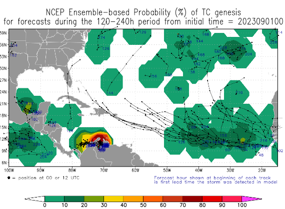
Ironic part: While everyone is watching is watching The Wave it's more believable that South Florida could face a danger from the South as we move into September but it feels like October. Tall poplar trees in Raleigh are covered in yellow leaves, Idalia acted like an October storm and caught a cold front. Look up above at the image and you will see that The Wave makes it across (most likely) a system comes up from the Caribbean and hits South Florida from the South... while everyone is watching to the ESE to see if a real September Hurricane might be coming to call!
It might. It's active. The Wave needs a strong, unbreakable High that helps it get WEST vs NW as all the new waves off Africa have done. Yes, they got a name, yes we are on TD 12 but they are so forgettable five years from now you will not remember which name went to which one nor how long they were even on the map, maybe you'll remember Gert!
That's it. Enjoy the Labor Day Weekend!
It'll be a weekend of clean up in places like Cedar Key and Horseshoe Beach and Perry and all the places covered with pine branches and small trees that went whoosh in the Hurricane Wind.
Stock up on hurricane supplies (food) while it's all on sale at the store for Labor Day Weekend.
It's September, yes there will be more storms, more hurricanes and probably more landfalls. And, its possible that Texas still could get a system. They do so want the rain, careful what you wish for..
That's it. Will see on Sunday what the models show for The Wave and how many named storms are left standing on the NHC map.
Sweet Tropical Dreams,
BobbiStorm
@bobbistorm on Twitter and Instagram
One of my all time favorite Jimmy Buffett songs
posted by BobbiStorm @ 10:26 AM
![]()


1 Comments:
Happy Meteorological Fall! 🍁🍂 Waves will come and go, but PSL is here to stay for awhile ... 😉
Post a Comment
<< Home