TS Idalia Forms Near the Yucatan .. Florida Bound! Franklin 100 MPH Hurricane. Both Moving Slowly. Idalia Forecast to Move Fast Approaching Landfall. Take Precautions Now! Pay ATTN to NHC Changes in Cone or Timing.
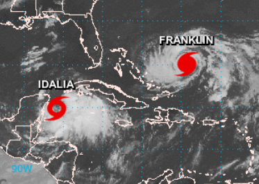
Tropical Storm Idalia
Hurricane Franklin.

Here's our current cone.
Know it'll change.
The biggest problem about writing a blog this morining is that we are in a very fluid situation and while Idalia is now a Tropical Storm, she has a ways to go before she consolidates the convection (mostly to the East) and pulls off the tip of the Yucatan and moves up into the very warm water in the Gulf of Mexico. She's over warm water, but the longer she sits the more upwelling would be an issue. But she is forecast to begin moving. There is dry air and high pressure to her North prohibiting her from leaving her current location and so until that changes, and it is forecast to change, she will be a messy, but developing Tropical Storm.

Compare and contrast with Franklin.
Both have dynamic issues.
Franklin is currently left side loaded,
tho strong hurricanes winds in the center.
Idalia located on the NW edge of convection.

Earthnull.
Idalia center close to land.

See the larger envelope of winds.
That area to her ESE has been consistent.
Once she resolves that issue.
Watch out.
Once the high pressure lets go...
.... Watch out.
The message with Idalia is to pay close attention to every change in the forecast path and impact dangers as timing is everything here. Don't get fooled into a feeling of false security as it's lollygagging around the tip of the Yucatan. Recon found it strong enough to be a TS regardless of it's current issues and closeness to land. And the big problem is the fast foward speed once it begins moving. Add in weather is fluid and the steering currents won't yet be carved in stone so before you have time to react, it'll be on it's way to your front door.

This is a 3 day Cone.
Slow, slow, slow... SPEEDS UP FAST.
Also know these forecasts can be iffy.
But this is what we are going with.
A hurricane in the Eastern GOM.
Intensifying.
Moving fast.
Not a good set up ever.
Now let's look at the end of the Cone

Faster moving.
And questions.
Big questions.
The left side of the one is far inland. The right side of the cone is out over the warm Gulfstream. One thing you can rely on is this Cone is going to change, it's a work in progress and one reason the NHC has it wider on the last few days is there is lower confidene in where it will be on the last two days exactly. History has taught us a fast moving, intensifying hurricane on landfall can and will cause the most pain, misery and destruction adding forward speed to it's strength and in this case there will be a gradient set up with the front that is pulling it North (more so if it takes the left side of the cone) and models have been extremely consistent.

Tropical Tidbits
Just so many questions. So prepare if you are in or near the Cone for this storm. Today is Sunday, use it wisely. Don't blow the food budget on the movies and if there is any medication you need for you, your children, your grandparents or your pets... get it filled now. Coastal issues will be huge with this storm and impacts will be far from the center that the NHC is tracking.
As for Franklin it's also stuck in weak steering currents, that'll change. And, it's intensifying and will be beautiful to watch from a safe distance as possibly a Major Hurricane in the Northern Atlantic. Idalia has the potential to be a Cat 2 easily, whether she realizes that potential? Time will tell.
Will discuss analogs and actual details on landfall once we have it moving and it has smoothed out it's track and issues.

Inside this picture (not Cone) pay attn.

Timing but remember things change.
But use it for now...as a guide.

Rain forecasts.
Lastly............
Never forget Tropical Waves.

Moving generally West... we will see.
Check back later for updates.
BobbiStorm
@bobbistorm on Twitter, Instagram and threads.
posted by BobbiStorm @ 9:00 AM
![]()


0 Comments:
Post a Comment
<< Home