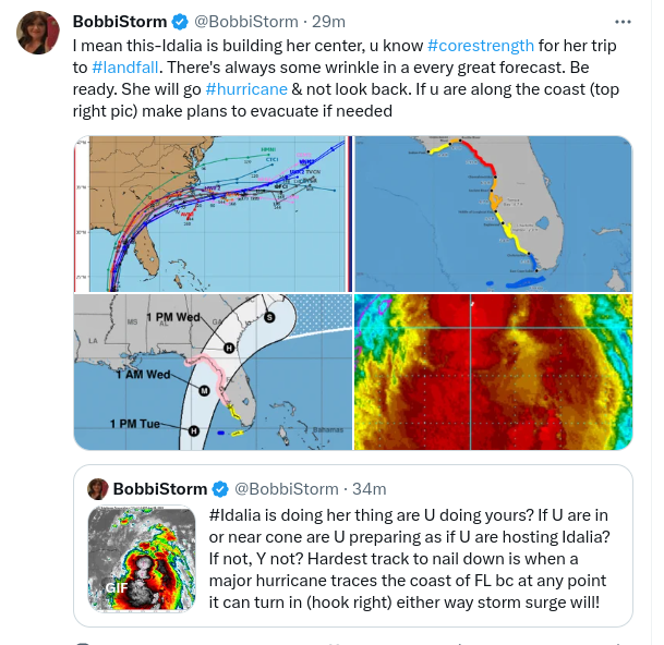
11AM UPDATE.......Prepare NOW! For IDALIA..............Franklin 145 MPH, IDA 65 MPH Intensifying! WATCHES WARNINGS. Many Moving Parts With Forecasts. If You Are in the Cone Prepare for Major Hurricane Winds. If You Aren't.. Prepare for Impacts, Coastal Flooding Far From Cone and Tornadoes in Squalls.
11 AM

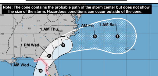
Cone above
Rainfall below

Wind Profiles

NOTE WIND, HIGH WINDS outside line of Cone.

Compare the line down the center.
STRONGEST HURRICANE WINDS

This area will get Wind
Steady strong tropical storm winds.
Steady strong hurricane winds.
High Wind Warnings.
Greens.... Squalls with torandoes.
Squalls with Thunderstorms.
Deadly weather conditions.
It's not JUST about the Cone.
Cones can shift.
They get bigger and smaller.

Look at Franklin in the top right.
Strong, round and eye.
Category 4
145 MPH Winds.
Now look at Idalia...
You can see where the EYE will be.
You can see a nasty tail setting up.
Idalia forecast by NHC to be MAJOR
CATEGORY 3
Picture Franklin just offshore Naples.
Offshore Tampa
Offshore moving fast Cedar Key.
Somewhere it makes landfall.
Further N maybe Cat 4 Big Bend.
Prepare now as if you are getting Idalia.
Along the coast... storm sruge.
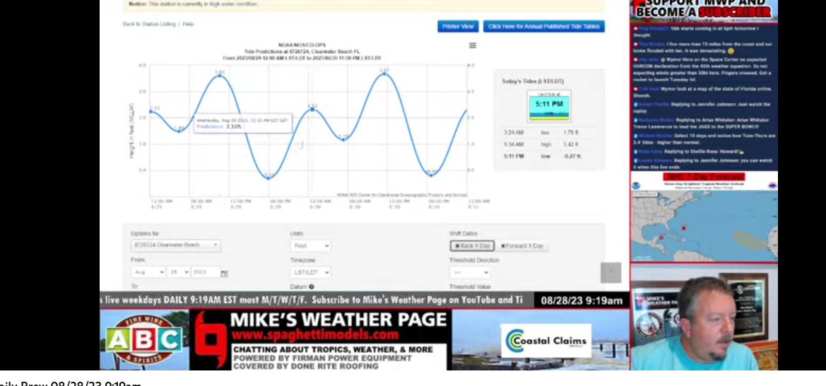
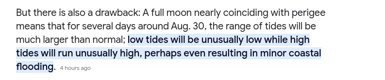
Idalia and the Supermoon Tides
Inland, Trees down, tornadoes
Wind.
Now is the time for action.
Do not wait.
I'll update later.
****
10 AM

Lots of moving parts here.
But first..........stop and stare a few seconds.
Not too long.
If you live in Florida you have things to do now.
Now.
Front stage for most of us is Idalia, bulking up in weight (color/convection) almost done with her Yucatan vacation ready to shoot North like a rocket towards the Gulf Coast of Florida. There's a frontal boundary to her North draped across the SE, another one will move down behind that but it's August and they can be hard to predict down to the minute. Add in, the eye of Fraklin distracting you from what looks like a messy Idalia. Idalia is not so messy, she's intense and about to go Hurricane. When an eye pops out you'll forget all about Frankling, but don't. Idalia will move generally North (do not get lost in NNW or NNE or Due North) it will gain latitude and at some point Franklin a Major Hurricane now packing 145 MPH will stop going NNW and begin to pull more to the left (NE) and when Franklin does that and where what will be Hurricane Idalia strengthening over warm Gulf of Mexico waters it will also want to hook right. And where and when at 11 AM this morning is very hard to tell, but the NHC is doing a great job dealing with all these moving parts.
Do not get lost in discussion.
Uncle Bob says...
..the neighbor says.
You read online ....
You have one job right now.
Prepare for this hurricane.
As if you will get the eye.
And......
EVERYONE GETTING FLOODING.
Far from the track of the eye.
Far from the track of the Cone.

This map right now if most important.
Impacts happen outside the cone.
The NHC tells you that but ppl don't listen.
Read the fine print.
I zeroed in here.
At 11 AM I'll post that map.
We can compare and contrast.
Yes, Tampa gets lucky often, but not always as it has a serious hurricane history in that the few that did hit it dead on set Tampa's growth back seriously. In 1921 the famous Cat 4 Hurricane hit near Tampa (do they ever thread Tampa Bay perfectly?) and it knocked it's Roaring 20s Building Boom for a loop, money went South to Miami that was just beginning a Boom and the Boom exploded in Miami until it began to slow in early 1926 for a multitude of reasons and then the Great Miami Hurricane slammed into Miami setting Miami's building boom back, 1928 a hurricane slammed into WPB and the money went back briefly to Tampa before the depression hit in 1929.
Why am I giving you a History Lesson on the Florida Land Boom? Because that's how hurricanes impact history and there were a lot less people living in Tampa and the surrounding towns in 1921 and now it's a huge urban city and many more people are in the way of Idalia than when my Great Grandparents lived there in the 1921 hurricane, leaving my Grandma the baby as afraid of hurricanes as she was lightning that shot through the chimney and danced around her parlor!
Why am I talking about old Floridians.
Because y'all gotta listen to them
Mike is an old time Floridian, he lives in the Tampa area in one of it's cuter little suburbs. And, at the moment he feels the weight of the world or at least Florida on him trying to carefully give information on how to prepare for rising tides, and all other issues. And, while he is from the Tampa general area he knows Florida well and he knows that they SHIFT... the track shifts, the track nudges and no one from Tallahassee to Tampa Bay can rule out some quirky detail in the steering currents doesn't happen and it turns in further South or it moves further West than anyone expected.
There is the coast.
Ignore the red dot I used.
A Major Hurricane tracing that coastline...
..waiting to turn in is worst case scenario.
Prediction wise.
And, where it crosses Florida...
Further up inland it's wider.
North of Tampa it's narrow.
And it'll be moving fast.
And back in the Atlantic IF it does that.
AND Atlantic Beach impacts will happen.
Tides, flooding, erosion.
Without a hurricane this happens.
With a hurricane, it's horrific.
This is the bottom line.
If you live in or near the cone.
You have 1 job right now.
Prepare for Hurricane Idalia.
Fringe impacts or direct.
And the eye will see very deadly winds.
Very deadly winds.
Not sugar coating this.
I'll update at 11.
But I wanted my thoughts up now.
While it's "quiet" waiting for the 11 AM
Hurricane Watches and WARNINGS..
Coming.
NOW IS THE TIME TO PREPARE.
Evacuate if you need to.
Get what you need to hunker down if you can.
Later..
BobbiStorm
@bobbistorm Twitter and Instagram
threads when I have time.
Be like Jimmy....
song teaches us.
Someone took the last plane out of Saigon.
If you're in an evacuation zone....
...don't wait to catch the last plane out.
Do it now.
Or drive inland to safety.
Learn from Hurricane Ian.
posted by BobbiStorm @ 7:18 AM
![]()


0 Comments:
Post a Comment
<< Home