IAN Landfall As a Cat 4 - Strong Back Side As Ian Leaves SW Coast. Inland Impacts There's a Reason They Closed Disney... Moved the Rocket... 2nd Landfall Up the Coast. GA SC NC. Expect Surprises in Track (Eyes Can Wobble) & Forward Speed & Intensity....
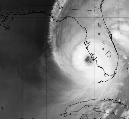
Landfall occured here at Cayo Costa as a Cat 4.
Currently the Hurricane has moved inland.

NNE at 8 MPH.
Still going strong.
"Only" 130 MPH inland.
Tonight it will begin to cross the state of Florida and it will be a long dark night for many people without power. I want to remind people NOT to go out tonight if the winds have died down in your area to see what damage is out there. Wait, spend the night at home and go on in daylight. More people have accidents and die AFTER the storm when they try to take care of property concerns and or drive into flooded areas. Just stay home tonight, deal with it tomorrow when the winds in your area have died down.

As for horrific scenes of flooding at the beaches and adding this was a daytime landfall, I'm hoping more people appreciate the power of water in real time vs an educational video shown about storm surge and flooding. I'll talk more on this tomorrow. Tonight the main advice I have is to stay INSIDE wherever you are if you are near IAN or in the track tonight. Also know that weather is expected across the state of Florida as squalls are moving fast across various areas.
Note all the warnings across Florida.
Including Miami and Broward.
Just stay home.
Stay safe.

Images are incredible.
Firetrucks under water.
Cars floating out to sea.
Punta Gorda currently getting slammed on back side.
More later...
... message tonight is stay where you are.
If the winds have died down do not go out.
Even if you are "far" from the eye.
Check in the morning.
Stay safe and pass that message along.
* * *

12:30 PM
Water literally sucked out of Tampa Bay
Ian nearing landfall in SW Florida.
To the South of Tampa.


155 MPH on the move to landfall...

Discussion 11 AM
"Ian is on the threshold of Category 5"
My question is ...what are they waiting for?

155 MPH moving to Landfall.
Coming in NOW!

Note this did not slow down to a crawl as recently discussed nor can you walk faster than Ian and that was quoted by many a day or so ago and bothers me as I didn't think it would stop and crawl it's moved steady for most of it's wind history. And, I say this because the current scenario is closer to the original scneario of it moving quicker at landfall.

It's foolish to think we can nail a Major hurricane track down to the exact location within a mile or so, too many variables and forward speed has been a variable varying often over the last several days. Tornadoes inside the eye wall are an issue, storm surge is an issue, everything is an issue.

Again orientation of the coastline here is everything. Here there is a curve to the coastline, a bit further to the North (not far) it's N/S and any wobble (as we saw in Andrew) can make a difference as to which beautiful, little bedroom community near the water is slammed with the most devastating winds.

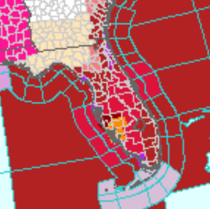
Current image of Interactive Cone from NHC.
Note also high winds far to the East.
Not hurricane force or TS but strong over a long period.

NHC upping wind estimates for NE E Coast of FL
As I mentioned earlier in this blog.
Strong hurricane on the move across FL...
..not going to unravel that fast.

Again use the Interactive Cone.

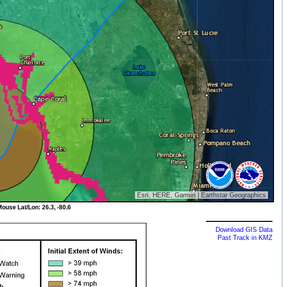
Hurricane Watch up thru coastal SC.

Note watches warnings along the coast.
Also to the East of Ian...
now is not the time to be out on Allgator Alley
Areas in dark green be aware you have wind.
Not dangerous Hurricane or TS but WIND.
Oh and TD 11 is on board.

In scheme of things not impt but it's a blog.
Ian being scooped up & moving towards land.
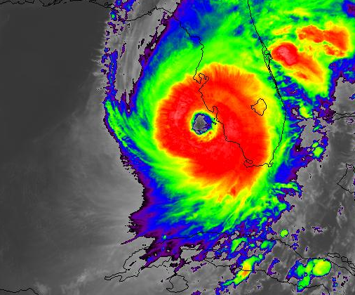
note the indentation on the lower SW side.
The link tells the story....
...image of WV loop
Will update at the top, please keep reading.

This blog isn't going to tell people to get out as conditions are deteriorating & many will not leave but should take shelter as best as they can & stick to the plan. People assemble all their hurricane supplies on the dining room table then run to a closet or bathroom when it gets scary & leave most of what they might need on the dining room table. Choose your spot. Bathrooms are good, however some have windows (not impact windows) and are more exposed than other bathrooms so if so find the best interior spot, interior closet & keep first aid, batteries, radio, weather radio, water/snacks near you. I'm putting this at the top as it seems obvious but it's not as people are nervous and focusing on whatever they think their priority is and running out into the house looking in the dark with a flashlight for a First Aid Kit is NOT the best time as sometimes the house itself begins to come apart near it's weakest link. Being honest.
We say hope for the best and prepare for the worst. So think worst case scenario.
All the advice we give for Hurricane Prep is really for a Cat 1, 2 and even a 3 but a tricky Cat 4 that could go Cat 5 and was more recently forecast to level off and decline in intensity that is still intensifying and still moving rather than crawling are the hardest hurricanes to survive.
So taking this situation in parts, every part is important but obviously the landfall location and intensity and forward speed are the most important.

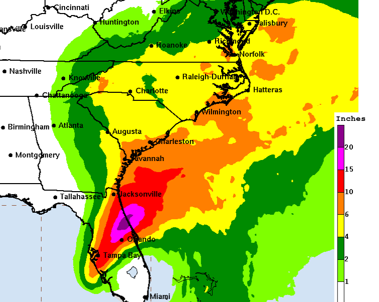
This coastline is one of the worst to deal with due to the orientation of the coastline (angle) and if you zoom in here you will see most of it is low lying, marsh, inlets, canals. Water rushes in from Storm Surge up each of those inlets, canals, bays and marsh covered area and to be honest it will take a while for Ian to even realize it's over land as so much of it is still over water and so much of the land is filled with water coverage.
The concept of "Brown Ocean Effect" means that storms can intensify while moving fast across marsh land aka low country aka swamps.

It's all about the terrain, the landscape.

Randomly, but on purpose, using North Port as an example as many across the country followed the story of Gabby Petito who was missing and the search for her boyfriend who was thought to be somewhere in the swamps. If you followed that story, and many did, you will remember due to high water during the rainy season a good part of the "park" could not be gone through and as beautiful a place as it can be to retire from say Minnesota winters it's not a good place to be in a Cat 3, 4 or 5 hurricane. You are naturally cut off as water floods everywhere and with that flooding comes Gators and not talking the football kind along with other dangers you can't imagine. This area was in the news for a long while and the terrain, landscape made the search almost impossible until the waters receded a bit after the rainy season. How much more so are those small, one story low lying homes tucked between marsh, canals and inlets have problems weathering a Major Hurricane?

And for the most part IAN is there NOW.
Edging closer to the coast.
The current Interactive Cone from NHC below.

5 AM is a bit North of Cape Coral.
Last night the cone was over Cape Coral.

At 11 the cone may move a drop again.
There are so many bedroom, small communities there I can't even begin to name them so I went with North Port as an example for several reasons but one it was in the news much this year and many can picture the quiet little streets with small, cute homes tucked in between canals, marshes low lying homes with little elevation and a storm surge is moving in fast. Flooding will be epic and the flooding will be the flooding every NHC director going back to Neil Frank warned about. Exactly where that eye wall and flooding occurs is everything. Does the water rush in or as happened in Irma does the water rush out of Tampa Bay?

Not the best place to ride out the monster below.

This is IAN from the NHC main page.
You can see the front.
I want you to focus on how it thins out to the North.

These are my own unique thoughts.
But they are important to what happens.

The front is thinner here...
...thinning.
This area will see a likely 2nd landfall down the road.

Front pulls in two directions.
It's late September not October.
Fronts are strong this year for September 28th.
But they are not strong as they would be in late October.
Forward speed of Ian is a huge question and has been everywhere the last few days with forecasts for it to slow down slower than it is going and for it to be moving extremely faster than it is now forecast to be. It was supposed to level off in intensity, there was much discussion on line last night around Midnight how Ian had peaked and yet we woke up this morning to 155 MPH and possibly strengthening.
Also know hurricanes this strong wobble and that wobble can be everything with regard to who gets landfall and the storm surge, the deadly winds. Andrew wobbled JUST OFF SHORE that wobble saved downtown Miami and destroyed Homestead Florida a suburb of Miami.

Does it move more to the left (North)
Does it lunge towards the right? (East)
Does it wobble back and forth?
NHC does the best they can.
But Major Hurricanes always hide surprises.

It can crawl along the coast parallel ...
Nick Sarasota & head closer to Tampa.
It can hook in just a wobble to the South.
IF you are IN the Cone NOW.
Expect you will get the eye.
IF not be very grateful.
I'll update at 11 AM.
Again as Ian strengthens the front is there but it's influence on a Cat 4 almost Cat 5 Hurricane is less and less and the high it carries with it aloft can at times reinforce forward movement. Charley was SMALL IAN is HUGE, 2 different hurricanes in the same general area. And, the eye wobbles sometimes within it's track and that wobble can mean life or death for some.

I'll update at 11 AM.
STAY OFF YOUR PHONES as much as possible NOW, Keep them ALWAYS plugged in to keep the battery at the fullest and use them as little as possible other than for an emergency or a text as power will go out across a huge area and you will not have power for a long time. If you have a generator... lucky you, use it wisely.
With prayers for those in the direct path of Ian and for those who live inland take every precaution you now to get to safety or secure your shelter. For those up the road as my Grandma would say ... Jacksonville, St. Marys, Savannah, Beaufort, Georgetown, Charleston, Pawleys Island, Myrtle Beach, Wilmington NC and even more so INTERIOR parts of Georgia, South Carolina and North Carolina think now what you will do if Ian comes to you!
Besos BobbiStorm
@bobbistorm on Twitter and Instagram
Ps again expect surprises in track, intensity and forward speed. Bugs me a bit as during Katrina a good comparison on some levels people were warned to move up into an attic and take an axe or to keep a skiff nearby. Flooding can and will be epic and destructive winds blowing apart shelters someone thought would be safe and yet not hearing enough discussion by those covering Ian trying to nail down the landfall for some win ...some pyrrhic victory of being the best met online. A hurricane is more than just the center of the eye and often the worse impacts are to the North or NE of that eye. And, twisters in bands circling fast, swirling around the dangerous eye can take lives far from the eye. And people racing out into the storm to suddenly change their location is best kept for experienced chasers. Nice to tell someone "get out now" if you still can but as we have seen in other hurricanes in low lying areas people both young and old drive off the highway into a flooded area and drown. The time to evacuate was yesterday, but you can find a safer space where you are... the safest spot and keep your wits about you as it is what it is and it's pretty much a Category 5 about as wicked as it gets. So much for the name IAN I can forecast totally that the name will be retired. That I can call............

Also nice to say stay at lowest level of the house.
But if the flooding begins FAST you need to move up.
Been there, done that.
Katrina a huge wet storm.
Andrew a dry small storm.
Each hurricane is different.
This is a Seminole Wind.
Blowing over low lying marshy area.
Canals, bays, inlets, swamps.
posted by BobbiStorm @ 6:50 AM
![]()


1 Comments:
Hey Bobbi, I absolutely agree. SW Florida is particularly vulnerable to surge and flooding. Although I believe that North Port has areas as high as 40-feet elevation. Still, you are trapped by flooding around there.
More tragically, SW Florida is home to a large population of older transplants from the Midwest and elsewhere. They are insistent on not evacuating in part from minimal hurricane experiences. Instead, if their neighbor says they are staying, that just reinforces their belief that it is okay to stay as well, which leads to whole neighborhoods staying.
As a Miami native and resident, I feel unusually lucky to not be living in a hurricane cone at this moment. But I am very worried for the millions(?) of coastal residents of SW Florida.
BTW- Seminole Wind has always been a great song.
Post a Comment
<< Home