Lee Forecast to Bring Bermuda TS Winds as it's Windfield Expands Wide... and Lee Moves towards Parts of NE and Canada. Nigel Waiting in the Wings for 2023 NATL Tropical Relay Race.
11 AM
NHC writes great headlines! Rest of headline...
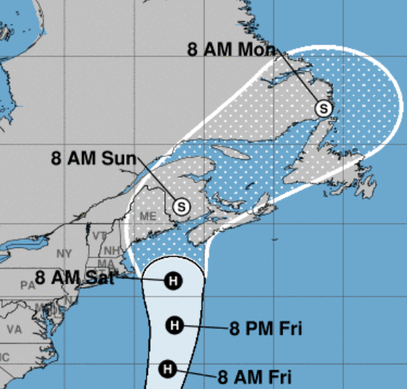
RISK OF WIND, COASTAL FLOODING, AND RAIN IMPACTS INCREASING FOR PORTIONS OF NEW ENGLAND AND ATLANTIC CANADA...
Yup. Models are messy and not always reliable.
At some point you have to make a hard call.
Warn the general area and they have.
Don't follow the center of the Cone.
The center can be anywhere in the Cone.
And impacts can and will be far from the Cone.
With hurricanes such as Lee that is transitioning into a higher latitude cyclone we zoom out and go wide and remember that impacts of many kinds may be approaching your area and you must prepare as for you any severe Nor'easter you'd worry on some. Read previous blogs to get that comment better, in truth NE is used to Nor'easters but those who went through Fiona in Canada got way more than they expected of a punch. Happens sometimes. Long Island, Cape Cod will have the usual impacts, to the South the beaches of NJ will have strong waves, high tides and well time will tell.
My apologies to Margot (a beautiful name) there were more important things to discuss this week.
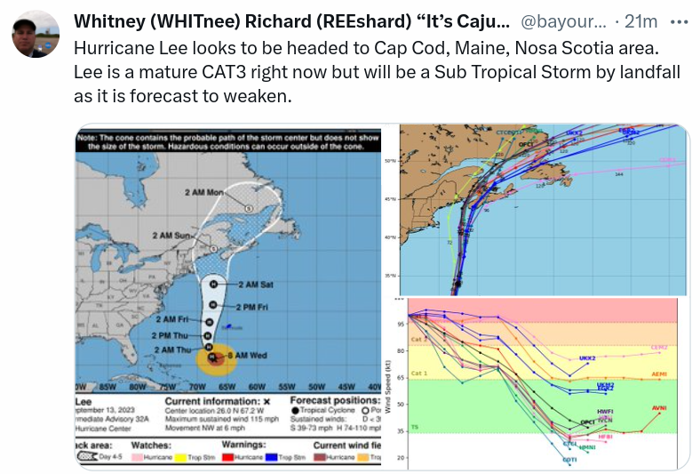
A friend of mine put this very well, so leading with it in the blog as it pretty much covers the bases. Currently a mature Cat 3 that seemed to have dropped anchor far to the East of Miami and just sat there spinning, fluctuating up and down in intensity. It has a great eye, it has an eye very prone to dry air intrusion. Even at 25 N (very tropical waters) it has the look of wanting to be a large, upper latitude Extratropical/Hybrid sort of storm. On some satellite imagery it looks HUGE as if it takes up a good part of the SW Atlantic. On other satellite imagery you see that really the strongest winds are compact within a small area and everything else is eye candy. Beautiful strands of clouds that you can see far away looking up at the sky, but safely away from the terror and trauma of a hurricane.
See the picture. Focus on this.
While looking at the loop below.

In motion.....
.gif)
1. The front steals my attention. The Southern part of the front is weak, the Northern end of the front is stron and it's calling out and has stolen Lee's attention. The top of Lee is leaning up as if it wants to embrace that frontal boundary and indeed it will in the not so distant future.
2. Oh look there's a new wave off of Africa, behind the wave that many models see as the next candidate to replace Lee off the SE coast in the same way Lee replaced Franklin. Seriously any form of life with a telescope on Jupiter must be looking down at Earth thinking "what's going on over there?" in that large blue ocean on Planet Earth???
3. Margot is the green/blue swirl in the North Atlantic far to the ENE of Lee.
4. Not much going on in the Carib and the Gulf of Mexico and whether you want to admit that or not it's most likely because of El Nino. The MJO is due to come into this region and there has been much discussion if the pattern will produce a hurricane where we usually see hurricanes form in late September and October.
Looking down the road.
Nigel is said to form....
...park itself E of FL where Lee did.

The EURO shows this on the last frame.
Interesting.
GFS shoots it faster out to sea.
Going wider.......
Down below on Sept 22nd we see nothing.
Nothing in the Carib.
Nothing in the GOM
Nothing threatening Florida.
Nothing approaching the Islands.
That brings us to one of my favorite lines from a song "where do we go from here" and that's the question of the day. We have had a busy hurricane season with lots of storms few will remember in a year from now. Weak one or two day systems or systems that spun for days out in the middle of nowhere. Many will say "hurricane season with prayers answered" for storm chasers they will not remember it so fondly. But, the hurricane season is not over yet we are kind of in the 7th inning stretch which is later than Halftime so I'll go with baseball over football.
Back to Lee tho for now...
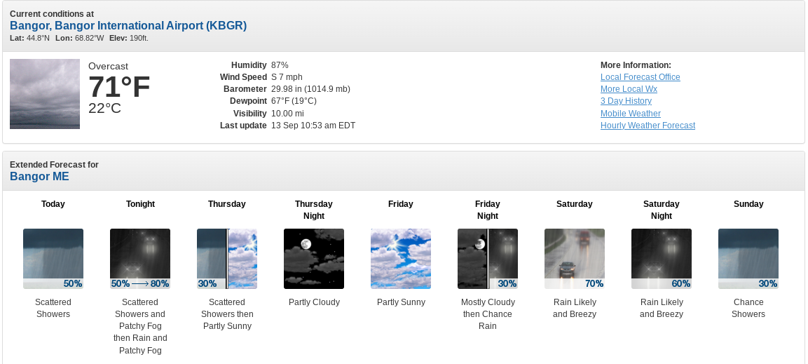
...let's look at a city in Maine.

Well Friday has a chance of sunshine.
Looks like a dark, stormy week.
Dreams of winter crashing into tropical systems.

"Please monitor latest NHC advisories"2
In places such as Bangor Maine up close to the Atlantic Coast of Canada in New England, it's a time filled with watching, waiting and reading updates in the weather forecast.
And that's my advice for those places in England in or near the Cone and as sometimes cones move your way, other times they move away but the cone only covers the center remember that and with Lee impacts will happen far from the center as it's not your Momma's Hurricane or even a Tropical Storm.
Sweet TROPICAL Dreams,
BobbiStorm
@bobbistorm on Twitter and Instagram
Here's to my Red Sox Fans who better pay attention to Lee and those beautiful beaches in Maine that I like so much, watch out a visitor from the South is headed your way! Take it seriously but it won't be a major hurricane and yet it may make a major difference in your world up along the way.
The land of winter coasts and hoodies for baseball.
Only need hoodies in Miami if the AC is on strong.
Love the Red Sox ... love the Marlins.
AC works great when the top is closed in Miami.

Me and my brother 5 years ago.
Was early before the game...
...he was working the Red Cross booth.
Miami Marlin Memories.
Lee won't be a Miami hurricane........
.......but it will be remembered my some.
posted by BobbiStorm @ 8:39 AM
![]()


1 Comments:
"Where do we go from here"
Now I'm singing, and forecasting.
Lee's been sucking in the dry air but on the most recent sat images he seems to be regaining his former concentric look.
Don't forget Lee's tail.
He's reaching all the way down to Porta Rico and Hispaniola.
Now back to the music.
"My Blue, Jean, Baby Queen. Prettiest Girl I'd Ever Seen."
"See Her Shake On The Movie Screen"
"Jimmy Dean" "James Dean" "Rock On"
Post a Comment
<< Home