Don't Focus on the Center of the Cone for Hurricane Lee and Landfall in Canada and Parts of the NE (Maine Especially) Get Weather From Lee. Don't Focus on Labels ... Hurricane Lee, Post Tropical Lee or Extratropical Lee. Follow the Weather & Your Watches and Warnings. Don't Forget About Nigel Forming in Theory Soon.

Lee moving "slowly" WNW at 7 MPH.
Quoting NHC Discussion.

Cone above.
No watches nor warnings for New England
NHC may hoist them for Bermuda.
Time will tell...soon nuff.
Moving slowly...
Black shaded area at the top of the NHC map reminds you that "hazardous conditions can occur outside of the cone" and this is really going to be the story of Lee. As tropical systems move North into the North Atlantic they begin to transition into a different sort of beast. Remember Sandy that looked gigantic, the subways flooded as the storm moved towards Landfall? Fires broke out on barrier islands, drama everywhere and yet the back side of Sandy began to disappear and NHC kind of pulled the plug at the last moment which ended up being lots more drama on "why did they do that?" and it took NJ and NY a long time to recover ....especially along coastal towns. Sandy was not a wild hurriane as it was down in Cuba ripping apart the landscape killing 11 people and terrifying people in Miami that one of the early forecasts would verify.

You can't even see Florida...
...let alone Cuba!
Sandy hit Jamaica as a Cat 1, it hit Cuba as a Major, intense Category 3 ...truly a tropical terror down in the deep tropics of the Caribbean. Sailed past Florida ...yes I went to the beach you could really "feel" Sandy offshore on it's way North towards a rare Mid Atlantic landfall.

Sandy in the SW Caribbean.
Sandy on her way to Mid Atlantic landfall below.

Rare set up, happens.
Note this was sniffed out early on.

Despite packing hurricane force winds...
...approaching landfall.
11 PM was set to be the last advisory.

This is it's Death Notice.
(it wasn't really dead....)

https://www.britannica.com/event/Superstorm-Sandy Britannical tries to explain the many lives of Hurriane Sandy that became Post Tropical Cyclone Sandy. I know, sounds a lot like name games but government agencies run by rules, it's technial, details matter. Looking back we just say "SANDY" and everyone knows what we mean. Article has some good graphics, here is one below.

What is in a name....really?
It's a big bad storm.... huge.
Moving SLOWLY now.
Once it did move...
....it moved FAST.

See Sandy, slow, slow, FAST, FAST!
Why am I talking about Sandy? The answer is obvious. Lee is NOT Sandy, but it's moving up from the tropics into the North Atlantic transitioning and despite moving slowly at 7 MPH WNW it will suddenly pick up speed and race towards which ever beach it actually makes landfall at. But, AGAIN "hazardous conditions .... may occur outside the Cone" and the Cone as good as it is... is almost useless when warning a large population that may or may not be in the actual cone as conditions far from the center of the Cone will get direct impacts from Lee. Landfall may occur officially just across the border in Canada but there will be impacts in Maine. It's not a Nor'easter and they are used to hurricanes and the areas that just had flash flooding hopefully don't get more flooding. When systems collide they go wide, impacts of all kinds can happen across the whole transition zone.
See Lee:

Meanwhile Models........
NHC puts this product out.

This is earliest time of TS winds.
This cone is better than the other cone...
..when it comes to a storm like Sandy or Lee.
It's based on Wind Probs.
Oh look JFK airport has wind probs.
JFK is on the water it could have problems.
Anyone mentioning stuff like this?
I know it's just "stuff" but it matters.
Always loved the Canadian Cone Map.
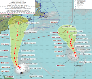
Shows BOTH storms (wow,what a concept)
Note a good part of Maine in their cone.
as is Cape Cod.
But again impacts will go wide........
... like a missed Field Goal.
Bottom Line:
Listen to your LOCAL Weather sources for possible impacts from Lee once it finally leaves the tropics moving fast up into the North Latitudes and it's power and fury goes wide and can and will impact many places acoss a wide area with multiple sort of impacts. It will not be a Cat 5, it hasn't been for a long time and only was for a hot minute. But it will pack a punch.
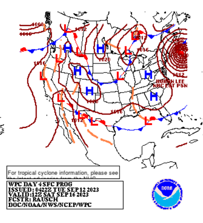
See the tight isobars around Lee.
That's gonna impact people.
Long Island, NY, NE
Maine as well.

Strong rains.
Strong winds.
Coastal Impacts.
Flooding.
Moving FAST.
That's WEATHER.We call that WEATHER.
I'm all about WEATHER.
If you want to be one of those anal people who only tracks the exact center of a storm as if it's not going to rearrange lives far from your perfect call for landfall... you be you. I'll be me. I'm about showing weather history, problems you may really have to deal with and giving a heads up to what you may see dealing with Lee.
One thing I'll give to Lee, thankfully has an easy name to type and say.
Remember damage from Sandy when it was Post Tropical. Remember how many Post Tropical storms we have had this year... since Don, Fralkin, Idalia and the whole Gert issue with ever changing names. Go to your local weaether sources, NWS or whoever you trust the most to give you the real deal on Lee and what you will see!
It's shape will deteriorate, it will be downgraded but you will still be dealing with the remnants of what was preivously known as Lee and the front coming together into a meteorological mess.
Don't say I don't warn you. Not Category 3 Major Hurricane Lee or even Hurricane Lee or you may be daling with Post Tropical Lee... what is in a name? You will be dealing with weather and high surf, beach erosion and hazardous conditions from what is left from Lee!
Stay tuned.
In my world I didn't like the PSL Keurig Coffee I made so I poured it down the drain. Then I went and made a Nespresso and that was oh my gosh wonderful! I put on TWC to see what Jim Cantore had to say but alas Jim was not on and after a short while of being annoyed... I put on Fox Weather to see if Bryan Norcross had anything to say and ironically as I was already almost done with this rant on the cone .....looked at and saw Norcross explaining problems with the way NHC communicated the message with Ian and the various Cones and media coverage and how impacts can happen across areas sometimes not in the Cone before they are put in the Cone and storm surge can be worse than they feared and what lessons we should have learned from Ian. Miami has been flooded by hurricanes that were making landfall in Naples where there was no weather and the NHC at the time explained the "weather" moved over the Miami area, but their forecast verified because the "center" did make landfall where they forecast. Stuff like that happens time and time again, Norcross rants on this time and time again. The NHC reminded people impacts far from the Cone could get impacts.... as Tallahassee learned and how Valdosta Georgia found out when the "weather" form Idalia moved faster than the center trying to do an eye wall replacement far to it's South before landfall and after gulping way too much dry air Idalia fell apart in real time intensity wise and it was hard to find any really strong sustained hurricane force winds but there was flooding and weather across a wide area!!
Nuff said. Stay tuned.
Oh don't forget Nigel is forecast to form and we are going to do this all over again because Hurricane Season 2023 has been like the Revenge of the Cloned Slow Moving Hurricanes ... except for that Idalia did come from the Pacific, crossed over and transitioned to an Atlantic Hurricane!
Sweet Tropical Dreams
BobbiStorm
@bobbistorm on Twitter and Instagram
posted by BobbiStorm @ 5:28 AM
![]()


0 Comments:
Post a Comment
<< Home