No Yellow Circle. Just a Purple Splotch...EPAC 70% RED. Lots of Colors ... Water Temps Heating UP Fast. Busy 2022 Hurricane Season Predicted.

Red Hot Convectin in the Caribbean.
Does it slide into the EPAC?
Sit a bit and drive models crazy?
Or try to move up towards warmer water?

Everything is about timing.
And a matter of degrees.
Difference between unfavorable and favorable!
Latitude to the North.
Longitude to the West.

It's got a purple splotch!
EPAC has BLUE a notch higher.

It has a pulse.
But which way does it go?

Oh my goodness..........
....so many possibiities!!
Well...it's not going East!
Epac currently at 70% for development.

So this model below is interesting. Shows the EPAC getting "something" but off the East coast some little, teeny, tiny closed circle appears. Some models keep it going that way ...wandering.... nothing to write home about but kind of interesting. Some models........form a strong storm, hurricane like in the GOM on the long range models. Not showing that model as by the time I press send it could be "poof" gone!! But, something is bound to pop up eventually ....sooner rather than later, close-in home grown or down in the Caribbean or a westbound stubborn wave that finds a small window of opportunity or some huge thunderstorm complex that lands in the GOM on the perfect day when conditions are just right for it to try and develop.

What it really shows is a HUGE HIGH!

Nice graphic from Accuweather shows the story.
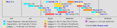
June story in the tropics.
Fairly close in development.
New Orleans have crazy rain today, 5 inches in one area and there were tornado warnings for Mississippi today and South Florida is having one heck of a Rainy Season, every day, in every way in every neighborhood the sky opens up and drops huge deluges of tropical rain down upon an area tired of getting heavy afternoon rains. It's beginning to feel ominous in ways as this Hurricane Season is predicted by many to be as busy as the 1995 Hurricane Season, though it's worth remembering that in June it was quiet except for Allison. Once it got going it was non-stop action. Now is the time to prepare, put away things that are non-perishable, paper goods,water, drinks and stock up on diapers or medications or both!
Honestly, there's no going back once it starts!
And prices are only getting higher!
So do what you can now.
You can also fill up empty soda bottles with water.
Simple things like that.
Just taking stock to see if you have hydrogen perioxide.
First Aid? Batteries?
See what you have so you don't waste money.
I can't promise you when but I can tell you it's coming!
Water warms up every day until everything is red hot.
Not splotchy red ... but red hot!
Sweet Tropical Dreams,
Bobbistorm
@bobbistorm on Twitter and Instagram
Ps... Until a Yellow circle appearsh....
... this is Hurricane Prep time!
song link ....
posted by BobbiStorm @ 2:48 PM
![]()


0 Comments:
Post a Comment
<< Home