Updated 11 PM -Tropical Storm Watch Posted Florida - Potential Tropical Cyclone ONE aka PTC ONE Advisory Package .. Should Be Alex By Landfall.


Compare and contrast with the 4 PM Below.

Mostly North but .1 degree more East.
Same basic thought process.
Same Watches up.

No changes in track or theories.
Most important graphic is this one below.
The deep orange color is up to 10 inches of rain.
Mostly for the South Florida area, Florida Keys.


I know there's a huge BLOB closer to Florida.
Currently it's the one on the LEFT...
On the right is a BLOB.
But sometimes centers do jump... stay tuned.
Tropical drama on June 2nd!
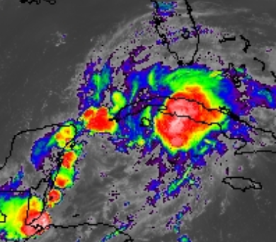
Close up we can see it clearer.

The bottom line with tonight's forecast package from the NHC and the discussion they put out with it highlights the point that the current center is a weak center at best. Often this time of year weak, sheared systems trying to form have multiple areas of "swirl" that look like centers. Sometimes, the center "jumps" and the new area under a strong ball of convection can become a new center. Movement looks erratic, but in truth it's one area all moving in the same direction. What is the problem you ask? A possible shift to an area closer to Florida and Cuba could change the actual track seen in the cone and in the models. BUT, in this case the convection (wherever it is at landfall or near landfall) is going to be the big WEATHER MAKER. Where the flooding rain and nasty squalls set up is everything. So until this totally forms and can be designated a Tropical Depression or Tropical Storm understand it is still in the process of trying to finding it's groove and developing a true center.
The models keep spitting out solutions based on data in and data out.
Recon will go in later tonight. We will see in the morning by morning light the first morning visible satellite imagery and see just what is really going on, until then it is what it is.
Prepare for heavy rain, strong gusts throughout most of Saturday not just a wild storm at 3 PM in South Florida, and there may be up to 10 inches of rain and I would not be surprised to see more in localized areas. That means flooding. Possible power outages. The good news is it is forecast to pick up speed soon and move rapidly across Florida and the adjacent Florida Straits. As weather is far removed from the center being tracked... strong weather could move in sooner rather than later.
Take things in off of your balconies and any large objects in your yard that might take flight in 40 MPH winds and squalls.
Nite,
Sweet Tropical Dreams,
BobbiStorm
@bobbistorm on Twitter and Instagram.
****
From 5 PM ...
Tropical Storm Watch for Florida.
Important Cone to Look at.......

Note the CONE in BLUE... the Tropical Storm Watch is in Yellow... and Miami far to the South of the Cone has a Tropical Storm Watch. Why you may ask? Because this time of year it is common to have poorly defined, poorly organized Tropical Storms with much of the SEVERE WEATHER with gusts and wind to Tropical Storm intensity FAR REMOVED from the center traveling along in the Cone.
Bottom Line here is it will be a Messy Saturday and into Sunday over a good part of Florida, especially South Florida no matter where the exact landfall will be as there will be much displaced weather. Hunker down, don't go driving around. Expect power outages and flooding especially in the areas prone to flooding. And, even in areas not prone to flooding if heavy amounts of tropical rain, copious amounts fall at an incredible rate ...which is common in June Tropical Storms... and when live wires come down into puddles that you can't see you could get electrocuted when walking into that puddle with your beloved pooch! People died in Irene in SFL in 1999 when out walking the dog; Mother, children, neighbor's children and I'm pretty sure the pooch died too. So don't laugh this off because it doesn't have 150 MPH winds and storm surge! Again don't look at the Cone and say "Oh I don't live near Naples" because I'm in Miami.. Hunker Down, Ride it Out. Feel free to send pictures @bobbistorm on Twitter..
Again what is a PTC? It's a Potential Tropical Cyclone. Note official warnings from NHC below.
"Due to the
possibility that the system could become a tropical storm with
impacts in the Florida Keys, and portions of the Florida Peninsula
and western Cuba, advisories are initiated on Potential Tropical
Cyclone One with tropical storm watches issued for those areas."
From NHC Discussion above.
Major details shown below:

Will be TS Alex eventually.

Currently the poorly defined, possible center we are tracking is far to the left of the beautiful blob of weather that looks like a strong Tropical Storm. Note the tip of the Yucatan is where the center may be, BUT often centers shift and redevelop under the stronger convection. IF that happened it would be way closer near Cuba. Rain is currently the name of the game regarding PTC ONE aka soon to be Alex.

Friday we will know better the exact details.
But the WATCH is up NOW!
Again the heavy storms in Miami today are NOT from PTC1
BUT that consistent convection only sucks it in.
I'll update this evening.
Besos BobbiStorm
@bobbistorm on Twitter and Instagram
song of the day
Link to keep:
posted by BobbiStorm @ 2:16 PM
![]()


0 Comments:
Post a Comment
<< Home