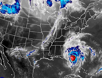
Matthew Moving NNW 12 MPH ..Winds 115 MPH... Damage in Daytona. St. Augustine. GA SC NC VA?
As people are curious...
...this is where that beach is if you ever want to visit.
Matthew has moved on...
Note the rain associated with Matthew is spreading North..
...into the Carolinas and Georgia.
And a long tail curves back into the Bahamas.
It's a big system.
And that rain is moving up with Matthew.

If you live in Florida and need help and aren't sure where to go..
http://www.floridadisaster.org/index.asp
Marco Rubio of West Miami fame (i lived there once)
Was asked on TWC what site to go to if you have problems in FL.
Immediately he said this one and named a few others.
A good site to remember.
To prepare and for after the storm.
Images coming out of Daytona Beach show huge damage.
St. Augustine may have it a bit easier.
The coastline curves NW a bit there.
Daytona and Ormond Beach have hotels on the water.
Hotel.. Pool...Beach.
Stayed there after chasing in Julia.
Truthfully was worried Julia was my last chance this year.
I did think a Caribbean storm would form that would be big.
But it seemed to be the Year of Invests this year til now.
Models are very tightly clustered along GA SC coast.
From there they diverge.
Some are beginning to show the out to sea track.
Some are showing the NE catch the trof...
Others do the loop de loop the media loves.

As it moves North it moves away from the coast.
And it turns RED again.
The Gulfstream there is WARM.
Fuels the storm.
Look at the storm now:
Water running through the streets ...
..people more safe that it would look.. in theory.
Let's look close up at that sign....
Welcome to St. Augustine Beach.
It will soon be departing for Tybee Beach, GA
Charleston and Hilton Head, SC
Waving goodbye ... maybe.. round Wilmington, NC
Great site on Mike's page to follow winds.
As we move North we get a different take on the models.
This is a projected path for Matthew.
Today it's all about St. Augustine.
Jacksonville. Neptune Beach.
Cleaning up in Ormond and Daytona Beach.
Possible tornadoes in bands coming in off the top of Matthew.
Check them out on Twitter.. Charleston SC NWS
Then go to their website.
Their area covers a wide area.
From Savannah North until Wilmington NC takes over.
If you go to Charleston, SC NWS
Remember when models showed it looping before there?
Hmmmm hurricanes move in real time.
They do not follow models.
Models follow the hurricanes.
They adjust in real time to new position of storm.
This is real life not a reality TV show.
This is not an interactive game on your phone.
Models are great.
But they change often.
The NHC errs on slow changes.
The front is coming.
Don't bet the farm on the loop.
Can happen. May happen.
For now the only thing that is important is this:
Part of that cone is off shore.
Part of that cone is on shore.
The forecast points are just waving at Charleston.
Savannah... Wilmington.
Myrtle Beach.
Wind fields go inland a ways.
Flooding will go up the rivers.
Fill in the low areas.
Creeks will rise.
I talk to Chick in the Sandhills.
He knows NC weather and especially that area well.
Even inland they are taking precautions.
I'm pretty sure if the Sandhills don't get a Hurricane...
...they won't complain they will be happy.
Trees come down in these parts something awful.
No one looking for power to be out.
And down by the coast...
..they will say "it's just like a Noreaster"
Savannah is built up high on a cliff overlooking the river.
A great place on St. Paddys Day
Approximately 49 Feet in higher parts.
Some parts are very low.
Low Country.
Tybee Island closer to the coast very low.
Stay tuned.......
......I'll update soon
Winds now show up in Virginia.
Chow for now..
BobbiStorm
@bobbistorm on Twitter.
I'll update after 5 PM Package


0 Comments:
Post a Comment
<< Home