Update 11 PM Questions... - Ian Still Trying To Organize. Looking Good But Not THERE Yet. Crusing In to Warm Water & FL Big Bend Main Concern Today... Models & Cone Prone to Change So Stay Tuned

This is NOT the healthiest system
Barometric Pressure is 1002 not even below 1000!
Yet winds went up... based on a dropsonde.
Being honest it has looked fairly crappy all night, that said it could look impressive by late tomorrow night. It is still getting it's act together, still organizing and the models infact did show this would be a slow process and those models verified so there is no reason to doubt it intensifying into a strong hurricane. Again the blob to the SE is not the center just a random storm down near South America coast.

This doesn't look like a 50 MPH TS.
That said we will go with it and continue on.

Close up of the end point in the 5 day cone.
It's called "Big Bend" for a reason.
Will see where it is tomorrow.
I have some issues that I don't want to go into here but let's look at this like a good mathematical problem.
1. Water is warm where it will be moving into. +
2. Shear is low where it is moving into +
3. A high may build aloft or is trying if so that's a plus. +
4. A front will move down and there will be shear closer to landfall -
5. Currently it's not well developed and it needs a vertically alinged center to take advantage of 1, 2 & 3.
6. I have heard no one mention how dry the atmosphere is out ahead of it ...why I don't know.

2 Upper Level Lows as well

If Ian was as well put together as Ivan was I can see it barreling through the Yucatan Channel, tip of W Cuba racing North looking for that front ...window... opportunity. Something seems off, not sure what it is yet and am sure we will find out. We also may be surprrised by how well it looks later tomorrow. So keep watching and if you live anywhere between Mobile, Alabama to Tampa, FL be prepared to go into action if the NHC advises you to do so.
Also know that the front could be strong as originally forecast and grab it faster. Know the front could be weaker as some models now show and it gets up into the GOM steering currents get odd and it does weird things. But that would be most unexpected. Until it gets going and is VERTICALLY ALIGNED in the atmosphere it's all just modeling and discussion. And, models do a good job ultimately nailing down the final track.
Lastly IF this is a sheared system after being a huge Major Hurricane the weather will be sheared across a large area far from the cone that tracks the eye and a good part of Florida could get way more than they expected because they were only thinking on landfall!
More Sunday Morning.............. * * * Sweet Tropical Dreams, BobbiStorm
SURVEILLANCE JET FINDS IAN STILL ORGANIZING
Love the NHC headlines.
They tell you much, pay attention.
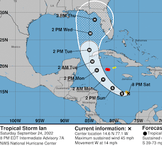
The NHC waits to be really sure before taking Miami out of the Cone and the fact that they did at 5 PM says a lot about the confidence in the newest models taking Ian further up into the Easterh Gulf of Mexico. I just looked at models, though I didn't really have to as it's obvious from the Cone what the models show. A lot of agreement in the 3 to 4 day and always one or two random models rushing off to somewhere else. As always we go with the consensus.

And that is why the 4 to 5 day is wide.
This is the Interactive Cone from the NHC that I suggest people learn to use as it has much good info and was developed to be helpful. The cone below shows the salient piece of information in that if Ian behaves and follows the program it will be moving fast at the 4th to 5th day. That's important as any wobble to the right can make landfall a city you didn't expect vs a bit further to the West Florida coast.
Ian has many things going for it that could make it a Major Hurricane. It is traveling across an area of extremely hot water and it's expected that a high aloft for a while ...while over that very hot water will allow Ian to explode into a strong hurricane. It also has some dry air out ahead of it and that isn't mention much but it's very noticeable on the Water Varpor Loop and that makes me wonder. And, again as the headline from the NHC says the jet "finds Ian is still organizing" and that's important as it's taking it's own sweet time.

Color scheme above is not for Halloween.
There's dry air up ahead of it.
Low shear is good...
Hot water is good...
It needs a way better center.
And, it's trying to find it's center.
Still trying to organize.
I will update later on tonight, but I want to say that for a while since the beginning I said the most likely target area for 98L would be the Big Bend area of Florida and this was days ago so I kept it wide. The models went left, the models went right and now the models snapped back and again I have to say "everyone from Mobile Bay, Alabama to Tampa Bay, Florida needs to watch Ian" as now 98L finally has a name. If only it finds it's center we will have the Hurricane the models have been snffing out. Also mention depending on the cold front that is moving South shear will most likely appear and begin to weaken (hopefully) Ian before landfall. And, that Jet is up there now trying to get a better handle on the upper air environment out ahead of Ian still down in the Cairbbean.
From way back when...
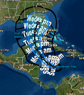
I made a silly fast map on Google for a friend.
Not to drive it but to have a map.

Current cone from NHC is right there.
And, it can change as Ian evolves.
Let's see what tomorrow brings.

Stay tuned.
Sweet Tropical Dreams,
BobbiStorm
@bobbistorm on Twitter and Instagram
Twitter usually weather
Instagram whatever.
Ps.. as I said early on I am concerned on the timing.
This is all based on a fast moving storm on day 4-5.
Things often change in real time...
posted by BobbiStorm @ 5:37 PM
![]()


0 Comments:
Post a Comment
<< Home