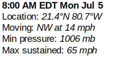
11 AM UPDATE - Misalignment of Severe Weather with "Center" - Perception of Dangers an Issue in South Florida (Miami/FLL/WPB)


11 AM Cone for Elsa.
NW at 14 (debatable)
65 MPH winds...somewhere.
Looks to be actually moving slower.
But that is "forecast" movement.

Ignore little circle that was my marker...
..when zooming in.
You can see where ELSA is.
SOUTH of Cuba.
Elongated SW to NE center.

Note the small red bright spot S of Cuba.
That's the "official" center.
Note the brighter larger red circle further South.
Note the huge tail to the East of the center.
Note the nice round pocket Elsa has (always)
Now look at this image below.
It's from the Mimic Loop.
The orange golds and reds are MOISTURE
Moisture = WEATHER = Trouble!
Blues dark blues dry high area pressing down.

Everything is being squeezed together NE - ENE
Like the center's signature itself on Earthnull.
Water Vapor below shows SW to NE Flow.
It shows HIGH (dark shades) pressing down on it.
Even a slight dry slot to Elsa's NW

This is a TOTAL disconnect with the 11 AM Package.
So what gives with the NHC?
Whether it's right or whether it's wrong the NHC job is to track the closed center of Elsa not the "weather mass" associated with Elsa. The NHC is tracking the center of the storm and it's movement and issuing a Cone for that center movement. I feel they are off and the fact that they hoisted a Tropical Storm Watch for the Tampa Bay area shows they see this scenario is not NW and they may have Tropical Storm force winds as the "center" moves up the West Coast and then gets SUCKED NE or NNE across Florida somewhere. As for the front to the North is stalled out and draped SW to NE across the area Elsa is already being grabbed by the forces of nature that guide it. They can and will update at 2 PM and 5 PM with a more in depth package if THEY feel they need to make minor adjustments so pay attention to each advisory.
BUT the HEAVY RAIN (moisture) and severe weather with possibilities of tornadoes and localized flooding is going to be sucked up towards SE Florida and maybe even the Bahamas. Why is the Cone nowhere near Miami and Broward IF they are definitely going to get weather from ELSA?
That's the job of the NWS local offices to issue watches and warnings of various natures such as "flooding" "flash flooding" "high wind warning" "small craft warnings" etc because even though it's part and parcel of ELSA it's not part of the "center" and the NHC puts a CYA disclaimer on EVERY cone reminding people there can be hazards far from the cone.

And the NWS covers the Weather.
The NHC does put up NWS info on their main page.
But people tend to look at the cone.
Local Weather people show the cone.

Miami Link:
The problem is a matter of perception by the general public that if they are not in the cone they are free to go about and be...take the boat out, take a road trip to a nearby beach... fly a kite... play in the rain. There is too much attention given to the NHC and not enough to the local NWS by the media. And without a tropical storm watch or warning or hurricane watch or warning no one pays attention to "small craft advisories" (unless they have a boat) or "high wind warnings" it just means "go to the beach the waves will be big but you aren't getting the storm" in their mind.
Early in the Hurricane Season and late in the Hurricane Season we get these junk storms that come up from the Caribbean and the NHC of late especially upgrades and even before that you had Irene that they insisted the naked center was headed towards Naples where Cantore had zero weather and Miami was pounded by all her weather that went East streaming NE just like this and Miami had flooding and the Mayor had to beg business owners to let their "workers" go home and school was cancelled without notice and parents argued with bosses to let them go get their kids but the streets were already flooded.
Shortly after that ( a year or two) the NHC referred to a "weather mass" outside the center but they dropped it and again it's the NWS job to write forecast discussion that wonderful on air Mets such as Phil Ferro on Channel 7 WSVN in Miami use to prepare their best forecast for you and warn you of your local concerns.
So ...........find a local meteorologist or someone online who covers your area that you trust and pay attention to what they say vs looking at the CONE with regard to THIS storm. If there is a Cat 4 headed WNW towards you use the Cone and all info from the NHC to protect life and property.
Got it?
I don't like it.
I think they should clarify this constant problem that always messes up some area being battered by storm surge or high winds and or flooding rains FAR from the center but this is the nature of the beast and they are a big anal on this so ... find your local NWS and a local met you trust.
I'll update tonight after their 5 PM package.
But there is no way a weak Elsa is going to barrel North into a strong high that is currently pushing down over the top of her... she will turn sharper and she will make landfall and she has already killed 3 people and the director of the NHC is correct you can have serious damage and death from even a weak tropical storm so do not ignore it if you are in the Cone or are expected to have serious weather outside the Cone.
Thanks. BobbiStorm

Click the link and you can see the problem
* * * * *
From earlier today

This is the Interactive Cone from the NHC.
Not interactive here but I prefer it to the other.

Elsa on color Water Vapor from NRL.
Navy site.
Getting that "embryo" look
Staying simple here for now and writing this while I sip sweet, strong Nespresso while staring at the wide range Water Vapor Loop. Going to keep an open mind this morning regarding Elsa. Bullet point style but not Bulletproof Coffee today but maybe tomorrow.
Pros:
She looks crappy shape wise like a minimal developing Tropical Storm
She's had problems staying with one center so NHC stays with original cone.
(u know that saying go home with the guy that took u to the Prom?"
(ps best not to date his best friend either just saying.........)
Water is WARM over Florida Straits they are an incubator for trouble.
She's carrying convection consistently in a pocket of moisture since Africa.
She's stayed alive even when she was going 31 MPH forward speed
Forward speed ...moving very slow over warm water S of Cuba can pull it together better.
She has a "look" like she really wants to intensify now, today.... maybe.
Cons:
It's early July.
Her steering currents left her on the prom floor and ran off with another dancer.
She's moving slower than she was - slow speed is a problem in forecasting.
She has crappy really crappy structure for a 65 MPH TS.
Her Barometer Pressure is relatively HIGH not Low.
Still a bit tilted though one center is winning out.
Has to cross Cuba somewhere (message to Elsa: choose wisely where you cross Cuba)
Shear is expected to be an issue ...expectations not always meet with expected results.
Questions:
She is cut off from strong steering currents and is wandering further NW constantly.
Looks more WNW to me but it's not my call.
She can easily grab onto that moisture trail and turn sharper....
She can easily wiggle up the West Coast of Florida over water.
Her moisture will be East sided and cover Florida if this continues.
Does she ramp up, pull together before landfall in Florida... she did it by Barbados.
How fast will she really travel... its always an issue with her forward speed.
How does Cuba's terrain ..........land mass impact her.
How fast does she soak up the warm water in the Florida Straits.
Lastly did the models miss anything?
Small core systems poorly defined often have models with bad data in bad data out.
Timing and strength forecasts have been off... even if TS has been liberal with exact intensity.
Bottomline...though she does not impress most mets much don't count out what trouble she can do down the line. Current image does not predict future results from Elsa.
I like her in ways but hate her in other ways; okay hate is a bad word .... cringe at times and then look back and think "okay not really that bad" and those are the tricky storms I've found. That "something" you cannot dismiss or count out and in this case she's been a fighter all the way through SAL against and into shear and not where a late June African Wave should be in early July so she's a rule breaker. That's often trouble.

Extra Credit:
Despite ridiculously high Barometric readings she has that "looK' like she really wants to be a hurricane again. Note much of her moisture is over JAMAICA despite the constant location readings as "near Cuba" and yes the top end of her is "near Cuba" and as she moves up into the Gulf of Mexico she will keep this profile unless strong shear knocks her off her feet and she can produce flooding rains across Florida after mudslides and floods in Cuba and then possible small end tornadoes in Florida especially in North Central Florida around Tampa North.

NWS Miami shows the current concerns for South Florida.
Many possible impacts and trouble ahead.
Not a Cat 3 but could produce stronger than expected damage.
Damage across a wide area.
Tropical Storms like this can be a pain in the ass.

Water Vapor Messages.
1. Notice the moisture over West Texas.
2. Notice the moisture in the Atlantic East of Florida.
3. Notice the dark air way behind her leaving her a bit adrift steering currents wise.
4. Note the small ledge of dry air from SW to NE just to her NW...
5. Notice dry air to her North carving out a "no go zone" for now.
6. Moisture to the SW of her anchors her and feeds her.
7. She's hiding down there South of Cuba the way Irma clung to the North Coast of Cuba.

Old cone.
Monday has her further North than current position.
Close but no Cuban Cigar.
They had her as a hurricane for longer....
I always said that Cone would not verify.
Close but no cigar.........
New cone this morning.

Stay tuned.
I'll update this afternoon.
My gut feeling is she is trying to pull it together.
Kind of like football, the longer time the quarterback has in the pocket well protected the better chance he can find a receiver down the field to catch his pass and end up in the end zone... SCORE!
Time matters, it changes everything from exact forecast track to intensity and time of landfalls. The more time over warm water consolidating the better chance Elsa has of staying stronger after she crosses Cuba unless she slows to a crawl and rains herself out over Cuba (long shot) and then just dumps rain everywhere in Florida trashing everything with way too much water.
Her original cone did not verify at all time wise ... intensity forecast is tied to timing. Something was missed by models so what are they missing now?
Time will tell.
Again it comes down to time...
Climo VS Models.
Stay tuned, Elsa has surprises up her sleeve if you ask me.
Besos BobbiStorm
@bobbistorm on Twitter and Instagram
posted by BobbiStorm @ 5:08 AM
![]()


0 Comments:
Post a Comment
<< Home