Will TS AMANDA in the EPAC Crossover into the Gulf of Mexico & Become Cristobal? Possibly... NHC Watching, We ALL Are Watching. Are You Ready for 2020 Atlantic Hurricane Season?

This is the area we are all watching.
Tropical Storm Amanda.
And possibilities in the Gulf of Mexico.
Invest 92L is in the Atlantic currently.
Chances low but there.

I don't want us to forget it.
While obsessing on Amanda.

These are areas being watched.
For an uptick in tropical trouble.
On May 31st, 20320.
Are you ready for the Hurricane Season?
Mother Nature is...
She's so ready she started early in May.
Next storm up in the Atlantic is Cristobal!
The image above shows Amanda in the EPAC.
Where Amanda goes trouble may follow.

Sometimes an oldie goldie satellite loop is what I need on a Sunday Morning when I stayed up til 4 AM and then woke up groggy at 9 AM. It's May 31st, 2020 and I decided why not track Amanda as it seems Amanda wants to do a crossover dance into the Gulf of Mexico and if it does it will identify at Cristobal. So 2020 right/ Right.
So what do you do when the coffee and the shower doesn't wake you up? I had one Reese's Chocolate Peanut Butter Cup for breakfast. Mike says chocolate helps a headache. Hmnn I digress. But it definitely did make me feel better!
This is our system below in the EPAC you can see Amanda down there flowing North with the flow and that's what storms do, they don't buck the wind or the trends they look for an easy path to take when deciding where to go.
God I love listening to u talk it’s almost embarrassing... listening to U Looping & eating Reese’s Peanut Butter cup for breakfast. Hello #SundayMorning #HurricaneSeason #Amanda in EPAC crossing over to dance in the Gulf of Mexico @tropicalupdate pic.twitter.com/572gMqH4rC— BobbiStorm (@BobbiStorm) May 31, 2020
So let's look at the 11 AM information and note the cone of possibilities and marginal errors.

I have 2 basic rules when watching models and the NHC.
1. My first rule is I dislike discussing Crossover Storms that begin in the Eastern Pacific and end up in the Gulf of Mexico and yet they do happen, there are exceptions to every rule. They are long shots, yet as we all know sometimes when a long shot pays off it pays off in a big way and often in a memorable way.
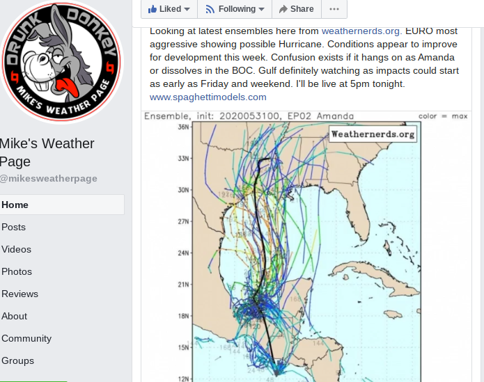
2. I hate when the NHC puts up these loops with the circular cone tracks they usually never quite work out. I'll say it again, Matthew did not turn back to hit Miami and Palm Beach so while odd things can happen I'd bet against it. Amanada could dawdle, create horrendous flooding, mudslides and possible loss of life in Central America and Mexico and then sit there and spin or die there. Something else pops up in the Gulf of Mexico as the models are hungry for trouble and it would still be Cristobal. The tropical ball gets picked up and Cristobal runs with it. Or.....Amanda does the crossover dance and heads up towards the general Houston area but I'd watch carefully all the way to the Sabine River with this one. Check out the rain forecast for the next 5 days and extrapolate that Northward.

If Cristobal forms in the Gulf of Mexico.
Can't promise he is a fast mover.
Models from Mike's Weather Page below.
He is updating 5 PM on Facebook I believe.
So where do we go from here?
I'm watching loops, models and Amanda...
And I'll update this blog later today.
I've been working on a post on the Hurricane Season.
But this is an issue that needs addressing now.
This is in the 7 day forecast.
That may change or evolve.
Weather evolves.
But when you see it here.
It's something to take seriously.
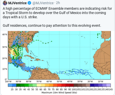
As Christopher Cross sings if the wind is right ... looks like the #tropicaldepression in the EPAC is going to go sailing into the #GOM not modeling it’s in the 7 day #forecast Hmn could this be #Cristobal ? #HurricaneSeason #2020 pic.twitter.com/0wQo2MNXzL— BobbiStorm (@BobbiStorm) May 31, 2020
Oh and never forget Africa.
The early season wave train is real.

Check out those models tracks.
I'll update later.
Besos BobbiStorm
@bobbistorm on Twitter and Instagram.
Labels: 92L, Amanda, Cristobal, GOM, hurricaneseason, tropics
posted by BobbiStorm @ 8:16 AM
![]()


0 Comments:
Post a Comment
<< Home