A writer and a tropical muse. A funky Lubavitcher who enjoys watching the weather, hurricanes, listening to music while enjoying life with a sense of humor and trying to make sense of it all!
Wednesday, December 15, 2021
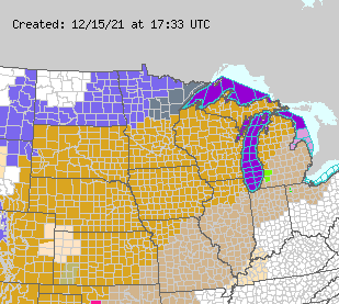
Updated 2 PM! High Wind Warnings in North Central US ... Strong Storm in NW... East Coast Still Waiting for Winter Weather. Noctural Tornadoes a Possibility.
Talk about a weather city!
Fog, Thunderstorms, Wind and Snow...
Understand the mustard brown is the area of concern.
Iowa is obviously where we are most concerned.
But weather is fluid.
And where "cells" that could spin show up...
...is what will tell the story.
Some updated discussion as new forecast discussion as come out of many NWS offices in the path of this severe weather event. Understand "severe weather" can include straight line winds and possible tornadoes that are moving at a fast forward speed and often form in real time so by the time they are visibly forming there isn't much time for warning. That is why it is important to set up your home for power outages and various weather dangers knowing where to go in your home as well as easy access to flashlights and fully charged phones and radios handy in case the power and cable goes whoosh with the wind!
Additionally the actual forward speed of this event will tell the story more than any factor on mutliple models that offer possible solutions. And, the possibility of nocturnal tornadoes that hit when most people are asleep is a real danger so please stay informed of the evolving situation as the evening plays out.
I just wanted to add in that this area is wide and goes beyond the general Des Moines area in Iowa that I am most currently concerned on. Even places further to the North such as St. Paul, Minnesota are not out of the woods. Below is an excellent forecast discussion from their National Weather Service that shows both the evolution and the dangers later this evening.
Their discussion sets the stage.
Then goes into important local details.
Today's Weather Warnings...
...High Wind Warnings in particular.
A wide area across the middle of the Country
The North Central US is especially in danger!
So what is it with all the high wind and severe weather warnings this December? Simply speaking we are in a stuck pattern where wintry weather and storms are in the NW and as they descend down into the High Prairie Provinces they Peter out a bit and when they get to the center of the country they run into warrm, moist air coming up from the Gulf of Mexico and wherever they meet trouble follows. I'd complain that was a long run on sentence, however this pattern has been a bit too run on for my liking as I'm in the part of the country where Winter is not happening and we are stuck watching as systems slide by to our North. While North Carolina is "North" Carolina, it is too far South to be getting any significant weather. May I add for most of the people who live here that is just plum perfect for most people here!
Ye Olde Earthnull shows the story well!
Big storm in the NW headed inland.
Air moving down across the Dakotas...
...warm air rushing up along the Mississippi River Valley.
Note the East Coast for now is quiet.
Actually in Raleigh we are fogged in....
...that happens often in December in NC.
i
Later today this happens!
You can easily lay this frontal progression...
...across the above Earthnull map.
And you can see where the trouble lies.
As always the Snow Total Graphic says it all.
So far this December....
...Winter is staying in the NW part of the US.
Very few instrusions South or into the MidAtlantic.
This too will change... but when?
You know everyone wants what they want whether it's likely to happen or not happen. That's just our nature and our nature varies from people who prefer mild weather and long seasons and that's why so many people from places plagued with nonstop snow who love the seasons but not snow move to Raleigh. Of course, people in Florida move to North Carolina because they get some seasons and the chance of snow. We have lots of seasons and very little snow in reality, but in any given year we can get snowed in for days. And, when we do get snow we make the headlines nationally as our roads ice over and are impossible to drive on, but that happens really rarely here. At the end of the 10 day period the chance of SNOW pops up for the New York to Baltimore I-95 area. Ten days away I remind you is not the most reliable forecat but it's an indication of when real "Winter" may happen and again it's worth noting we are in meteorological winter not WINTER after the Winter Solstice.
If you have friends or loved ones in the shaded bullseye area shown at the top to this page or a landlocked hurricane fanatic .... please pay attention to local warnings from your local National Weather Service. I use the word "local" twice, because it needs emphasis. Nothing is as valuable in this situation as paying attention to your LOCAL weather experts who can and will sniff out any dangerous set ups and please act accordingly and follow their expert advice. People could lose power, so set yourself up in case that should happen now and hopefully it doesn't happen.
Iowa is especially under the gun for trouble.
Windy trouble in particular.
From Rochester Minnesota South....
...into Iowa and surrounding states.
It's going to be a WINDY day!
The experts have insisted this is less about tornadoes and more about high wind warnings and straight line winds that will be followed by cold weather. Note such winds can turn over high profile vehicles such as large trucks as they travel across the highways of that area. Trees can come down somewhere and well in truth we have to wait and see what will really happen and hope there are no surprises.
That's it for today.
Not a very tropical weather blog this morning, but we are far removed from tropical trouble in our part of the world and so following the weather wherever it takes me.
Location: Miami, Raleigh, Crown Heights, Florida, United States
Weather Historian. Studied meteorology and geography at FIU. Been quoted in Wall Street Journal, Washington Post & everywhere else... Lecturer, stormchaser, writer, dancer. If it's tropical it's topical ... covering the weather & musing on life. Follow me on Twitter @ https://twitter.com/#!/BobbiStorm


0 Comments:
Post a Comment
<< Home