UPDATED 70% RED Invest 95L Forms in the Caribbean with High Chances on Being a Tropical Depression Over the Weekend While Epsilon Spins Out in the Atlantic. All Eyes on the Front. How Strong is it Really & How Deep Does it Go.
 '
'70% as of 2 PM
Recon scheduled for a Saturday Date.

It's got a look.
It needs more than a look.
But a look is better than nothing.

Better image below.

Has that rudimentary baby dinosaur look.
In the pocket... like a quarterback.

Those are the players.
The front futher to the NW.
The riff raff in the GOM
Invest 95L
To complicate matters...
.steering currents compete for it's attention.

One model shows 2 small centers .. kind of.

Kind of pulls up fast....
...not buying into that personally.
And if you want real fun.
Run this model.
That model basically takes Zeta like some old Volkswagon Bug it's Grandma left it from the early 70s up across Florida on a wild road trip along the coast, through the Everglades and then up through the Hill country after seeing all the sites it's always wanted to see. Really you can't make this stuff up.
I showed lots of images because I'm at a loss for words really as there are any number of scenarios that can play out. If the front is that strong and dives down then it can definitely grab it. We can go from currently no shear to shear everywhere. It's just too early to tell the tale or promise you anything.
It's there, it will up the ante for rain for the weekend in South Florida, Cuba and the Florida Straits.
Again there is a circulation but then there's an area like a caboose it's got attached to it as well. That elongated area down to the SE bugs me. I'm not in love with it yet, but it definitely has my attention. Official forecast for Monday in South Florida is below.... so keep your eye on it. I'll update when I can i've got something really valuable to say.

Ps Models watching but they vary greatly

* * *
Keep reading if you didn't earlier today.

Isn't the world a beautiful place as seen from a model that looks as if it is painting a portrait more beautiful than any that Van Gogh even did and he did a whole lot of portraits! Hurricane Epsilon looks like a bright yellow sun up in the heaven and Invest 95L looks like a red scropion down in the Caribbean debating where it wants to go after it crosses Cuba.

50% in the 2 Day as of 8 AM
60% in the 5 Day as of 8 AM
That escalated fast!

I went to sleep a bit late last night after the big debate and woke up around 5:30 AM and promptly fell back to sleep until 10 AM. I never sleep til 10 AM. After looking at what wasn't Invest 95L when I fell asleep I was greatly amused that overnight based on a few model runs and a "look" the NHC went from nothing to something really fast and we were suddenly at 60% in the 5 day and the 5 day would impact parts of Florida possibly so everyone is back on board the boat that barely 24 hours ago people didn't think would ever float.

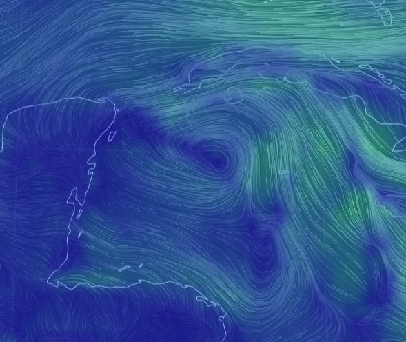
Visible Imager on the left of the "center"
Earthnull on the right showing a center ish area.
Shows a few things but won't discuss that now.
I wouldn't call it a strong circulation yet.
But it's getting there one hour at a time.
This is why I talk about a pattern set up and how it's better to watch the flow in the atmosphere more than just whether or not the EURO has joined the GFS in an unholy union creating a hurricane somewhere that everyone feels could actually form. It's late October and we watch the Caribbean and there has been consistent convection and Earthnull has showed a weak signature and models have given iffy support off and on so you ignore the models and you wait for it to develop and it it indeed it seems to be developing. Remember this is the same system the NHC pulled the plug on and then rushed to plug it back in once again as I pointed out the other day as all other agencies and sites were assigning possibility percentages as if it was the line in Vegas saying something will develop in the Caribbean eventually.
So let's look close up at Invest 95L
Looks a bit like a Scorpion currently.
Scorpions can have a real sting to them.

Models shown below.

Yes, they are not very helpful.
Well it lifts out of the Caribbean.
That is for sure.

It's on radar out of Cuba.
Cuba is watching it carefully.
As Cuba stands in it's way ....
...first stop on it's journey.
But where is it going really?

Here's our view from Zoom Earth.
A great site to use.
Note the huge front to the North.
This is the formation zone for what would be Zeta.

So the real problem is obvious and I've talked on it often online and here and that is it all depends on what the frontal boundary does and each model right now is feeling up one part of the elephant and putting out their own headline "ZETA HEADS INTO THE GULF OF MEXICO!" and another model is all excited and screams "ZETA SLAMS MIAMI!!!" and yet another model shouts "ZETA FORMS AND RUNS UP THE COAST OF FLORIDA" and you think to yourself ..."wait, which coast the West coast or the East coast" and then you see the last model and that one shoots it off towards Louisiana and you think "oh no that can't happen again" and everyone all at once in a loud choir from their individual homes screams "when is 2020 gonna end??" and the answer is... not yet, it's not over yet so buckle up and settle down and get a grip and wait for this to form, wait to see how strong the front really is and wait for a few more model runs.
It's also logical that something forms and heads into the Caribbean and the strong convection gets sheared to the East over Florida and we've seen that set up more often than the stars shine at night and the moon eventually goes full. Or it develops much the way the GFS said and EURO hinted at in long term models several days back and slides off of Cuba and moves towards South Florida and then does it go to the Bahamas or slide up the coast? It is possible if the front is strong that the front grabs it and runs with it up the coast, but what if the strong Halloween front doesn't go Boo and goes OOPS and stalls out and then what? Late October and early November bring so many odd possibilities track wise so let's wait and see what develops, where it develops and how strong the cold front is in real time.

The GFS God Bless it is advertising snow in New Mexico and the Panhandles of Texas and Oklahoma, I've got friends there and the snow stole my attention from the blue tropical moisture in the Caribbean. Other models hint it stalls, falls apart or pushes through and stops and ....well whatever you get the idea, it's too soon to know for sure so check back later as the old Magic 8 Ball loves to say.

Oh and yes there is always that model.
Forms off of Miami Beach kind of....
... I can promise Florida gets more rain.
No matter where it forms nor where it goes.
I'll update later this afternoon...
...after the next model runs.
And the satelites fix themselves a bit.
But hey isn't this arty fartsy?

Besos BobbiStorm
@bobbistorm on Twitter and Instagram
posted by BobbiStorm @ 8:49 AM
![]()


0 Comments:
Post a Comment
<< Home