1st Invest of the EPAC Hurricane Season - Orange Circle 50%

The Eastern Pacific Hurricane Season usually begins on May 15th..
We seem to be getting an early jump on the season this year.
NHC ORANGE
It has a 50% chance currently of becoming the first tropical system in the Eastern Pacific AKA EPAC.
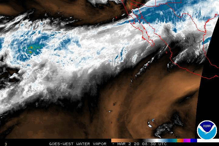
Actually looked better earlier... but it has been there for days consolidating so it is very worth watching.
Currently known as 90 E

They put out a special statement.
000
ABPZ20 KNHC 062017
TWOEP

SPECIAL TROPICAL WEATHER OUTLOOK
NWS NATIONAL HURRICANE CENTER MIAMI FL
120 PM PDT TUE MAY 6 2014

FOR THE EASTERN NORTH PACIFIC...EAST OF 140 DEGREES WEST LONGITUDE..

A LARGE AREA OF DISTURBED WEATHER LOCATED SEVERAL HUNDRED MILES
SOUTH OF MANZANILLO MEXICO IS ASSOCIATED WITH AN ELONGATED AREA OF
LOW PRESSURE.  THIS SYSTEM IS EXPECTED TO MOVE GENERALLY NORTHWARD
AND THEN NORTHEASTWARD TOWARD THE COAST OF MEXICO OVER THE NEXT
COUPLE OF DAYS.  ENVIRONMENTAL CONDITIONS APPEAR TO BE FAVORABLE FOR
SOME DEVELOPMENT DURING THE NEXT DAY OR SO...BUT UPPER-LEVEL WINDS
ARE FORECAST TO BECOME LESS CONDUCIVE WHEN THE DISTURBANCE
APPROACHES THE COAST LATER THIS WEEK.  THIS SYSTEM HAS A MEDIUM
CHANCE...50 PERCENT...OF BECOMING A TROPICAL CYCLONE DURING THE NEXT
48 HOURS...AND A MEDIUM CHANCE...50 PERCENT...OF BECOMING A TROPICAL
CYCLONE DURING THE NEXT 5 DAYS.  REGARDLESS OF DEVELOPMENT...LOCALLY
HEAVY RAINS COULD AFFECT PORTIONS OF SOUTHWESTERN MEXICO OVER THE
NEXT FEW DAYS.

ANOTHER SPECIAL TROPICAL WEATHER OUTLOOK WILL BE ISSUED BY 8 AM PDT
WEDNESDAY...OR SOONER IF NECESSARY.

$$
FORECASTER PASCH
Usually I don't go all ga-ga over the EPAC, but its the first invest and the start of things to come..

Nice to see tropical action on Spaghetti Models.
You might want to familiarize yourselves with the various links on his page. It's a real one stop shop where you can find everything you need in one place...easy on the eyes ...visually a tropical feast of satellite images and information to get you through the Atlantic Hurricane Season which should start on June 1st... but you never know for sure until the first storm forms.
Take note here on the 7 day that moisture begins to spread into the GOM by way of Mexico.. also note that the Atlantic is dry as the big, huge Bermuda High has been in place for a while now.
It's sort of like saying the new baby mama is not giving birth just yet, but the baby is in place.
http://www.hpc.ncep.noaa.gov/basicwx/day0-7loop.html

Is this Amanda or just an Invest and a batch of tropical weather? Only time will tell...
www.spaghettimodels.com

As for me I've been away for a few days in Key West. Nothing like driving across through the Gulf of Mexico and the Atlantic like you are threading a blue needle. I'm back, in Hollywood Florida, and back to watching the tropics. Nowhere like Key West... really and I've been a lot of places. Just wake up, wander around and see the beautiful delights... so many colors, so vivid and I'm talking about the foliage not the places on Duval. The air moving fresh, a breeze coming straight at you from Cuba and the scent of flowers in the air. Wow... nice bar there too...

That's a "pineapple upside down cake" drink... vanilla vodka, pineapple... lots of good things...
And, yes of course I got a margarita at Margaritaville....and watched the sunset... and rise... duh ;)
Stay tune.. I'll update in real time as the NHC updates the information...
Besos Bobbi
https://www.youtube.com/watch?v=R_M6TNxUqC8
Gotta start the season off right with the patron saint of storm chasers... Jimmy Buffett..
posted by BobbiStorm @ 2:34 PM
![]()


0 Comments:
Post a Comment
<< Home