El Nino - Saharan Dust - Warm Water in E ATL and MDR. Which Factor Will Rule in 2023... How Strong Will El Nino Get? How Long Does SAL Rule? Do the Math or Just PREPARE NOW... It Only Takes 1. 1992 and Andrew is a Lesson. Some Tropical Storms Refuse to Die & Stay Alive Til They Hit Their Sweet Spot!

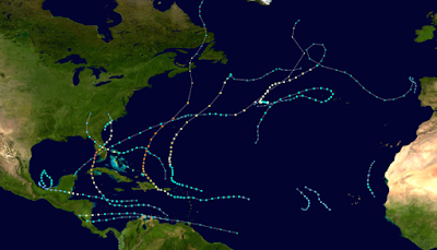
Every tropical weather person is staring at some variation of this map, meaning we are all obsessing on the El Nino that is coming on strong. And more so watching the warmer water temperatures in the East Atlantic into the Main Development Region (MDR) showing warm, welcome, friendly water for strong tropical waves leaving Africa. As much as that's a strong signal, it's not as strong as the El Nino deep reds and oranges off the coast of Peru which is where a traditional El Nino hangs out first before moving West into the Pacific.


If you have been watching you will know that Mother Nature has gone all out crazy with her red and orange crayons here! And, to me that's bigger than warm water in the Tropical Atlantic. While I do think it's a big factor in the early part of the hurricane season when early well developed tropical waves plop down into waiting, warm water that's welcoming them and trying to convince them they can go the distance... but can't they?? Definitely by itself that seems scary, and then you look at the Saharan Dust (SAL) maps and go "oh, wow that's strong SAL" and you start recalculating your tropical mathematics hypothesis for the 2023 Hurricane Season. Again Mother Nature gone wild with that Red Orange Crayon!!

That much RED is a huge STOP SIGN!
Unfavorable environment.
Dries up waves.

Waves currently coming off....
you can see where the SAL rips the top off.
Bottom heavy waves.

My ballroom Fandango map above shows it as well.
The pale blue polka dots are SAL.
Dry Saharan Dusty Air..
That's a no go...
If you will remember a while back there was much discussion on how warm the water was in the MDR and many expected a busy hurricane season, not so long ago and we waited and waited and one by one SAL sucked up all the moisture out of those very promising tropical waves that landed in warm water as the upper level environment was not conducive to development no matter how warm the water. While the season showed promise in Click Bait articles online promising you a very busy season with multiple Major Hurricanes, the season was slow to start and didn't get going until we wished it had never had gotten going as it produced Ian.
Lots of blue squiggly lines in the warm Atlantic.
Those were storms that couldn't gain traction.
Died out in the dry, dusty air despite warm water.
Some stayed low (avoiding SAL) crawling into the Carib.
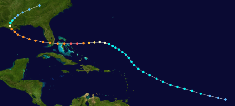
Until Earl and Fiona came along in September the season forecasts for an above active season seemed a bust. Then models latched onto a late season tropical wave that would make it into the friendlier waters of the Caribbean and move up towards landfall in the Eastern Gulf of Mexico as a Major Hurricane. Ian was the whole season, unless you lived in Hispaniola that did get nasty weather.

Irma approaching Florida.
Floridians fleed North..
..or hunkered down.
Terrified.

And as I said yesterday, everyone remembers that one season that was dangerous when the water in the Atlantic was hot, hot, hot and the 2017 Atlantic Hurricane Season terrorized the Caribbean Islands as well as the state of Florida when Major Hurricane Irma made a bee line for the whole state of Florida. Yes, in 2017 a very warm MDR with what seemed like little shear and unimpressive SAL created havoc in the Caribbean.
Warm water alone does not make for a bumper crop of major landfalling hurricanes.
El Nino alone will not shut down the entire hurricane season.
El Nino usually lessens activity in the Western Carib due to shear and near the Yucatan.
Shear comes and goes, it pulsates.
Saharan Dust alone will not shut down the hurricane season tho it may lessen the numbers.
I'm not even going to discuss MJO tho it's enough to say a strong MJO in El Nino years does it's thing.
Warm Water is a Plus.
El Nino is a Negative.
Strong, long Saharan Dust is a Negative.
Bottom line is, just because the water is warm in the East Atlantic and MDR if SAL is strong then tropical waves break their promises and have problems gaining traction. The problem here is that often the strong ones that survive the shear will develop closer in and that puts Florida and the Bahamas in play as well as the Carolinas. El Nino years have delivered some of our strongest Major Hurricanes so while they can lower the numbers of storms and ACE (accumulated cyclone energy) it only takes Andrew to leave the memory of 1992 being a horrible hurricane season in South Florida and Louisiana/Mississippi.
Andrew is the perfect example.
A strong, stubborn tropical wave....
..struggling through unfriendly waters.
Refusing to die!!
And when it hit that sweet spot...
..it never turned back.
Andrew in late August.
Miami will never forget.
And that is why no one can tell you for sure what will happen this year as there are mixed signals and depending on which signal does what over the next month or two matters. Does El Nino ramp up as the Mighty Euro Model predicts? Does SAL stay strong and persistant? Will the waters in the MDR near East Africa continue to be warmer than normal?
So many questions.
You have 1 job!
Prepare Now!
Prepare now and buy things when you see them on sale, put things away, conserve here and there as in hide some tuna and school snacks. Take one out of the pantry and hide it with the hurricane supplies, lock up the hurricane supplies. Fix a broken window now. Do what you have to do as hurricanes are the one natural disaster you have plenty of time to prepare for vs when the earth shakes and quakes and or the volcano blows!
Don't say I didn't warn ya.
Besos BobbiStorm
@bobbistorm on Twitter and Instagram
Twitter usually weather, Instagram weather and whatever.

posted by BobbiStorm @ 9:15 AM
![]()


0 Comments:
Post a Comment
<< Home