PTC3 Forecast to be Claudette Headed For Louisiana, Mississippi and Alabama... Florida Should, Could Get Weather As Well. Time Will Tell. Still Too Soon... Waiting for a Strong Center to Form. Prepare Now!
Potential Tropical Cyclone 3
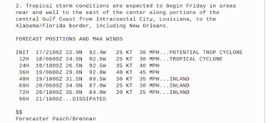
NHC issuing advisories for the potential storm.
Good idea as there is often little warning time...
...in the Gulf of Mexico.
Things can come together quickly.
Especially with the holiday weekend.
Cone is shown below.
It IS forecast to be a Tropical Storm soon.
Conditions are not excellent.
Water temps are supportive but...
...marginal.
The bottom line here is that until the center comes together and we see what is under the hood of this storm it's hard to buy into any one solution completely. The environment does not support a strong hurricane and it should become a Tropical Storm. The steering currents are fairly set in stone but when dealing with a "cold front" that's not so cold in June... you never know for sure. This area already has had too much rain this year and flooding has been an issue in some areas. So this is misery on misery for a region that was overtaxed last year during the busy 2020 Hurricane Season. Trees can go down, low lying areas can and will flood and with this being Father's Day Weekend it's important for fathers to know now is not the time to take the boat out, go fishing or camping in an area with a weak but messy tropical storm.
I'll update in the morning. I'm watching in real time, it's always an amazing process to watch even though I've seen it over and over but the Gulf of Mexico takes a weak, crappy storm and the shape of the Gulf sort of surrounds it, cradles it and often what is born is not always what we expect.... a storm blooms, spreads out and there's convection everywhere. And, often it's m heavier in an area further from landfall.
REMEMBER the NHC only plots the landfall, they issue information for the area but the cone is for landfall. So it's important to check with your local NWS offices as each office as your own back and your specific backyard's needs. The NHC covers the wider picture, the NWS covers YOUR specific needs so check with your local weather sources.
I'll probably update tonight.
Besos BobbiStorm
@bobbistorm on Twitter and Instagram
Ps... It is what it is... trust me it could be way worse and if this pattern continues ... it will only get worse deeper into the 2021 Hurricane Season. Hate to think that this season is a Deja Vu sort of experience for many still suffering from last year.


0 Comments:
Post a Comment
<< Home