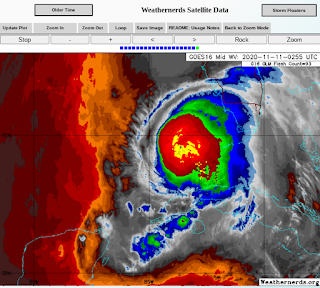
UPDATE ETA Moving NNE Towards Florida West Coast.. Big Bend Region -Dropped Anchor "Drifting South" NHC Warms Up to the Old GFS Track I Mentioned Yesterday. Theta Exists and IOTA is Coming Soon! ETA VIDEO
I'll venture to take a late night guess and say...
...ETA will come together close in and intensify.
That's been the signature this year.
And, that is what we are seeing now.
The problem with that is weather will move over, towards and into Florida way in advance of it's arrival and it's worth remembering Eta is a right sided storm with dry air on it's Western Back side. It's not just Tampa that has a bay and beaches on the coast there as there are many smaller bays, inlets and low lying areas so this has the potential for a continued flooding that Florida has dealt with on in South Florida and that wet misery will move inland in a swath between Orlando and Gainesville (current thoughts) on it's way back over the Atlantic most likely. You didn't think this would be simple and end fast did you?
Models are definitely coming together.
Track towards Big Bend of Florida...
Crystal River, Ginnie Springs.
Tampa North but how far North?
A lot to think on tonight.
More tomorrow.......
* * *
Decided to use this great chart from Zoom Earth.
Great site really.
Eta drops anchor a bit.
Theta moving East ... away.
Speaking of Mike I saw his name up on TWC
His video was shown from Eta.
Funny story about that in that a while back I got some great hail video and the same online group asked if they could use it and it was shown on The Weather Channel. My best friend in Miami was so excited to look at the only channel she basically watches and see my name show up. She called me as if it was the biggest thing in the world, and while it was nice I've had weather video before on air but it made me giggle. That's how I felt when I saw Mike's familiar image on TWC when I woke up yesterday.
Anyway, I'm leading here with Mike's graphics, because to be honest unless I want to read the discussion it's easiest to look here and move on ... on days like today. Even though we are very busy with the new Theta, the old ETA and the soon to be IOTA it's basically a quiet day. Eta is actually "drifting South" officially and the new cone is a blend of the old cone that was heavily biased towards the EURO and they added in much from the ignored GFS that seems to have gotten that slow westward movement and dip down. The old GFS showed Louisiana as the target for it to make landfall as it falls apart finally, so the new cone is moved a drop more to the left leaving Florida more and more out of the cone. Again the cone in November is deceptive because ETA will be an unbalanced moisture deprived storm on the West and the weather will lean East. Iota is forecast to move WEST into Central America and that's been the plan for a while with that one. I wouldn't be surprised if another area forms that is more interesting, but for today despite all the drama of 2 named storms nothing much is going on. South Florida is trying to dry out. A cold front is going to stall out West of me and I'm going out today to get things done.
Until things begin to play out we won't know for sure if the NHC will come around and go totally with the GFS or they will just leave a huge round cone in the short term and figure out what it will do later. Eta is moisture deprived and yet it's swirling around inside a bubble sort of like it has it's on Caribbean Gyre going on. I'll update later today after the afternoon models come out and we see what Eta does today.
Jim Williams also went down to the Keys to meet Eta and try out some new equipment he has that worked well, the exterior microphone really picked up the sounds of a tropical storm. I gotta say Tropical Storms are fun to follow because you have less to worry on damage and destruction wise but in the details they are wonderful to chase. If you want the calm, quiet of an eye then Eta is not your thing and that's okay because it takes all kinds. Normally Jim wouldn't chase this weak a storm but he did want to test the mike out and glad he did because he gives a clear, lucid version of chasing while explaining what is going on and he's brutally honest; he's not one to hype a medium range Tropical Storm into "OH MY GOD LOOK AT THAT WIND" and his mind goes back to chasing Cat 5s such as Michael. You learn a lot. So enjoy, and while at it if you are bored his youtube channel has some excellent interviews with previous directors of the Hurricane Center as well as other interesting tropical topics. Jim's goal with www.hurricanecity.com was to build a site that educated people about hurricanes, their history and all the details you don't normally get on other sites. He did a very good job, Yahoo and other sites use his statistics all the time as he has one of the largest data bases of hurricane history information online.
Video from TS ETA
from Jim Williams of HurricaneCity.com
@bobbistorm on Twitter and Instagram


0 Comments:
Post a Comment
<< Home