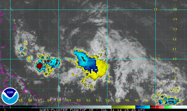
Invest 93L Has a Well Defined Center... but can it keep it's convection? The Recon Planes go in...
The beauty of a naked circulation is that you can see the circulation. You can see all the way down into the "A well-defined low pressure system"
The only real important update from the NHC this morning is that they are calling it like they see it. It is a very well-defined low pressure system.
Official NHC discussion:
"TROPICAL WEATHER OUTLOOK
NWS NATIONAL HURRICANE CENTER MIAMI FL
800 AM EDT THU JUL 31 2014

For the North Atlantic...Caribbean Sea and the Gulf of Mexico:

1. A well-defined low pressure system located about 650 miles east of
the southern Windward Islands has been producing organized shower
and thunderstorm activity during the past several hours.  If this
activity persists, tropical depression or tropical storm advisories
will be initiated later this morning.   Interests in the Lesser
Antilles should monitor the progress of this disturbance as it moves
west-northwestward at 15 to 20 mph, and watches or warnings may be
required for some of these islands later today.  A Hurricane
Hunter aircraft is scheduled to investigate the system this
afternoon.
* Formation chance through 48 hours...high...70 percent.
* Formation chance through 5 days...high...70 percent.

Forecaster Pasch"
The other important piece of information is that the planes are taking off...
"NOAA’s G-IV jet is scheduled to fly around the tropical disturbance that is located in the mid-Atlantic (AL93). The jet will collect data in he environment northwest and around AL93. The flight will take off at 1:30 PM Eastern. Below is the flight track."
Look at this close up. Hidden in the "center" is the word "Hi!" that rhymes by the way with EYE.
If and when TD3 gets a name and becomes Bertha that area would become the eye of a hurricane or the CDO of a strong Tropical Storm. Because it's late summer... hot and dry from Saharan Dust Invest 93L has peeled off her white clothing and gotten down to the basics. And, because she is "naked" as we like to say we can see where her center is very clearly.
Let me make this clear. For years we would call tropical waves under investigation an "INVEST" and now the term has gone public and is being used by the media. An INVEST is a TROPICAL WAVE that is being investigated by the powers that be who are running models on it for forecast purposes.
Once a closed circulation develops around a well-defined low pressure system (tropical wave) it becomes a Tropical Depression and advisories and sometimes watches & warnings begin. When that Tropical Depression attains the wind speed of 39 mph it becomes a Tropical Storm. They only give wind speeds in increments of 5 so most people think it starts at 40mph. Now you know how the system works.
Now let's talk about what is going and what is steering our future TD3 or Bertha.
Loop the link below...
http://www.ssd.noaa.gov/goes/east/tatl/wv-animated.gif
As I mentioned the other day IF a small ULL would form to the immediate NW of the Invest it would stoke the fires of the "well defined center" of the tropical wave and the wave would FLARE up like someone fanning a small fire. And, that is what is happening. That is why Invest 93L is alive and kicking this morning. Yes it has dry air and it has to battle with shear down the road but if you are on the right side of an ULL it can ventilate a wave and ratched it up a notch to a Tropical Depression and possibly a named storm.
That is why the planes are going in and that is why the models woke up this morning and latched onto INVEST 93L as an entity that may need to be reckoned with down the road...
Note the ULL is hard to see but it doesn't exist and it's not a strong one. If it was stronger it would kill it. Because they are both weak... it's doing it's thing and helping Invest 93L along.
What do the models show? Where does it go?
I will update this later today with more track information as after the planes get there we will have better data for the next run of the models. Garbage in ...garbage out is the old saying. Better data in...more reliable tracks out.
http://www.ssd.noaa.gov/PS/TROP/floaters/93L/imagery/ft_lalo-animated.gif
The biggest problem Invest 93L has at the moment is it's inability to maintain convection around it's naked center. It flares up..turns bright red on funktop and then the red dissipates again.
Another possible problem it has is that new convection far to the LEFT (WEST) of the naked center persists in blowing up and weak systems often attain multiple centers. IF at any time the NHC has to "reposition" the center to the West than it will be on top of the islands and the track will most likely be more to the south of the current track into the islands and more to the left (west) of the track later in the forecast period as it approaches Florida. That is a real IF but something to know can happen.
Stay tuned to see if Invest 93L becomes viable and attains a real designation as a TD or TS.
Besos Bobbi
Ps.. I do have a song but it's not for now it's for after it deserves a song. It's got a way to go and it's not very consistent. The NHC likes consistency before it upgrades a storm. They also like hard data and the recon will get them that...


0 Comments:
Post a Comment
<< Home