Watching the Tropics and Waiting...
I keep watching the Juice Loop and watching the passage of energy from one area to the other in the Great Big Blue Tropical Basin... a lot of blue and I don't mean "sky blue" but dry blue... dry air and a lack of yellow orange color which is what we should be seeing. It is worth noting the ITZ is beginning to become more in line with climo... still a lot of African Dust drying out the Far Atlantic ..

So, nature being nature wants to flow, to move, too ooze and transfer energy around the planet so she looks for another way, another opening ... like a "back door" on an old computer.
Hurricanes serve a purpose, so do Upper Level Lows as do all types of weather, they keep the air moving around Planet Earth. Mixing, moving, flowing.... we are not a stale, stagnant planet and the upper level air patterns, ocean currents... all work hard ..overtime actually to keep this a beautiful place for us to live.. most of the time :)
Studying the tropics without the help of an INVEST or the NHC issuing more information as they do when there are yellow circles means reading and talking to friends on Twitter, reading various governmental discussions which don't say much and going with your gut... it's not easy. It's like playing I Spy or whatever it is people play now days.
From the Atlantic NHC Discussion
"UPPER LEVEL LOW IS CENTERED OVER THE CENTRAL GULF
NEAR 24N89W. RAIN AND SCATTERED SHOWERS ARE N OF THE YUCATAN
PENINSULA FROM 21N-27N BETWEEN 85W-91W. EXPECT THE TROPICAL WAVE
TO MOVE W OVER THE NEXT 24 HOURS WITH CONVECTION. ALSO EXPECT A
SURFACE TROUGH TO BE OVER THE TEXAS COAST OVER THE NEXT 24 HOURS
WITH CONVECTION."
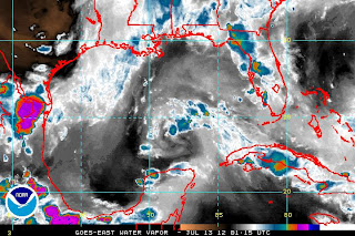
SEE: Upper Level Low in the Gulf that is going to blow the nice little circulation center ..or "twist in the atmosphere" near Tampa out of the water.. most likely.
http://www.ssd.noaa.gov/goes/east/gmex/wv-l.jpg
Note the reason you go to the WV is because on other imagery you cannot see the Upper Level Low, it is as if it goes rogue.
Look how detached the ITZ flow is from the moisture up near Florida. For something to really get going it needs to make a connection. A quarterback needs a receiver to throw or pass the ball to or he grounds it or goes down trying to scramble. Hoping that makes sense...
Next you go to the Marine site.............and it says:
"SYNOPSIS...A FRONTAL TROUGH HAS MOVED INTO THE NW WATERS AND IS
EXPECTED TO STALL FROM THE MISSISSIPPI DELTA TO SE TEXAS. THE
RIDGE WILL REBUILD W TONIGHT PUSHING REMNANTS OF THE FRONTAL
TROUGH NW OF AREA EARLY FRI. TROPICAL WAVE ALONG 82W S OF 25N WILL
MOVE INTO THE MIDDLE GULF SAT AND SUN...THEN WEAKEN AS IT PASSES
THROUGH THE SW GULF ON MON."
THEN you go to the Discussion out of Tampa NWS:
UPDATE...

"A WEAK AREA OF LOW PRESSURE IS LOCATED NEAR THE MOUTH OF TAMPA BAY
THIS EVENING...WITH SCATTERED SHOWERS AND THUNDERSTORMS CONTINUING
ACROSS THE FORECAST AREA. WILL CARRY CHANCE POPS ALL AREAS THROUGH
THE REMAINDER OF THE EVENING HOURS...WITH ACTIVITY THEN EXPECTED
TO FOCUS OUT OVER THE GULF FOR THE MOST PART AFTER 2 AM. THE
EXCEPTION WILL BE OVER COASTAL ZONES...ESPECIALLY ACROSS SOUTHWEST
FLORIDA WHERE STEERING FLOW AND SURFACE SPEED CONVERGENCE WILL
REMAIN MORE FAVORABLE TO PUSH A FEW SHOWERS/STORMS ONSHORE.
OVERNIGHT LOWS LOOK ON TRACK TO BOTTOM OUT AROUND 70 TO THE LOWER
70S INLAND AND IN THE MID TO UPPER 70S AT THE COAST."
Back to the NHC Discussion regarding the diffluence out near the Upper Level Low that I wrote about this morning.
THE ATLANTIC OCEAN...
TWO TROPICAL WAVES ARE OVER THE ATLANTIC. SEE ABOVE.
ELSEWHERE...WIDELY SCATTERED MODERATE CONVECTION OVER THE
BAHAMAS FROM 25N-29N BETWEEN 72W-80W MOSTLY DUE TO UPPER LEVEL
DIFFLUENCE FROM AN UPPER LEVEL LOW CENTERED NEAR 27N74W. A 1032
MB HIGH IS CENTERED W OF THE AZORES AT 36N37W PRODUCING FAIR
WEATHER. A SURFACE RIDGE AXIS EXTENDS SW FROM THE HIGH TO
32N70W. IN THE UPPER LEVELS A SERIES OF SMALL UPPER LEVEL LOWS
ARE CENTERED OVER THE CENTRAL AND WESTERN ATLANTIC AT
33N42W...26N64W...AND 27N74W. SCATTERED RAIN AND SHOWERS ARE
NOTED OVER THE CENTRAL ATLANTIC FROM 23N-28N BETWEEN 44W-62W.
EXPECT...CONTINUED CONVECTION OVER THE BAHAMAS OVER THE NEXT 24
HOURS. ALSO EXPECT CONTINUED PRECIPITATION WITH THE TROPICAL
WAVES.
BOTTOM LINE:
NOT MUCH HAPPENING... BUT... NOW ...there is more to watch than yesterday...
Nice day today on a personal level. Nice despite a bad headache, too much rain, too many cicadas and yet had a nice day... a quiet dinner with Tofu Curry and Sushi :) and Thai Tea... nice... very nice. An almost cool breeze in the evening. Watched Burn Notice and enjoyed the AIR BOAT RACE ... now that is Old Miami. Someone working on that show must really have a touch of Old Miami in them.
Enjoy the nice weather.... if you don't have nice weather... do something else... go to a Mall, a library ..crank up the music and play Jimmy Buffett... one thing you know for sure about the weather always, wait a while... it will change :)
Sweet Tropical Dreams, Bobbi
Ps... a Space Alert of sorts has been issued for Solar Activity which will hit the earth just about the time the Mercury Retrograde begins on July 14th.... which coincides with Bastille Day... have some French Campaign and enjoy the day.


0 Comments:
Post a Comment
<< Home