Hurricane Harbor

A writer and a tropical muse. A funky Lubavitcher who enjoys watching the weather, hurricanes, listening to music while enjoying life with a sense of humor and trying to make sense of it all!

Wednesday, June 29, 2016

GFS Conjures Up Epac Action... Time Will Tell. Cape Verde Waves Bigger, Better, Higher... Songs and Random Musing

sat_ir_enh_east_loop-12.gif (640×512)

What am I watching?
Not a lot.
Two sides of a sagging frontal boundary.
One part is in the GOM..
...other part off the Carolinas.


Not much going on....
....but things will change soon.

The GFS finally stopped showing hurricanes in the Gulf of Mexico.
It seems to have taken it's show on the road to the Epac.


Could this happen?
Maybe... 
60% chance in 5 days.


It's having problems....

sat_ir_enh_west_loop-12.gif (640×512)

If nothing develops someone really needs to read the GFS the riot act.

For now the GFS seems to be dreaming of Canes.


So that's the official story.

Oh ... waves by Africa... 


Look at that new wave...
...look how high it is... 
How RED it is with tinges of purple.


Hmnnn....
Purple in the distant Atlantic ...

Add in look at the high that currently takes up the Atlantic.
Anything that tries to develop is West Bound... for a long time.


But for now nothing is out there other than possibilities.

So I sit and stare at the NHC site....
... I keep hoping every six hours to see a yellow X.
No yellow X
Nope... Nada.

Just random thoughts on maps and weather.  The NHC map is suddenly bugging me. You know the big dark blue map on their main page that looks empty and naked without any yellow x or oranges Os. 


Example.... 
The dot over the o in "No" looks like a punctuation point!

Is that supposed to be Bermuda?

If you haven't grown up in the great city of Miami...
...you may not understand this.


Nice shade of purple.

So if that's Bermuda... looks off.
Looks like NOEH!! NOEH!! NOEH!! 
Like they are putting an accent on the word NO!!
Watch the video above you'll understand..
Around 4 minutes in... 
...after the difference between bitch and beach become apparent.

Next... 
I stare at the Great Lakes... 
I dream of Palm Trees.... 
Coconut palm trees...


IF there was a yellow X
I wouldn't be obsessing on Bermuda and the Great Lakes.
See what I mean?

Check back tomorrow and see if we have a yellow X.
Oh heck check back to see how that Cape Verde wave is doing.

Besos BobbiStorm
@bobbistorm on Twitter

Ps...today's post is a tribute to my friend Fishing :P


Yup vintage Johnny Cash

What did you expect me to put up here??


Monday, June 27, 2016

Tropics Monday .. Quiet For Now. Red Cross Needs Your Help with Floods and Fires. Be a Friend and Give Please!

sat_wv_east_loop-12.gif (640×512)

Starting off briefly today with some tropical discussion.
Then moving on to the big weather story.
So bear with me please.

Not much going on right now in the tropics.
This is the time that sets up the tropics for trouble down the road.


A cold front dangles across the United States.
Actually two cold fronts...


Moving towards the SE and yet fading away.
The dangling front brings two problems.
1... More rain for the Appalachian areas that had flooding.
2... Stalled out fronts can bring tropical trouble eventually.

Sunday's image shows the cold fronts evaporated.
They turned into stationary fronts.
More rain in some areas.


Note again at the end of the 7 day period the High backs off.
Not going to talk on the models today. 
Talking on what is here and there today and tomorrow..
And what the set up that may be opening the door on tropical trouble soon.

latest_wv_loop.gif (535×440)


Note old tropical waves firing up as they approach the islands.
Lows along the SE coast from old stalled frontal boundaries.
Note new wave off Africa is much higher than the last.

Close up look on that wave.


Rolling eyes on the Google ad but sharing my annoyance.
I'll get sick of whatever gown I buy before I ever wear it.
BUT.....NOTE how high the new wave over Africa is... 
Not worrying on ending a sentence with a preposition...
..as much as I am worrying a bit on what this season may bring.

It's a matter of time.
It's not time yet.
But those waves are getting near 10 degrees North.
July may bring us some very mature viable waves.
And yet Saharan Dust is there as always but some will survive.

We aren't there yet but a process is going on that gets us there.

jsl-l.jpg (720×480)

That covers the tropical part of this post.
If you do not want to continue reading I ask you to do one thing.
Donate to the Red Cross.
The rest of the post explains why I ask you that.

www.redcross.org

Oddly last year we were covering floods in Charleston ...South Carolina at the end of the Hurricane Season when the classic "fire hose" set up besieged South Carolina with historic floods. This year we are covering Flash Floods that set up near Charleston in West Virginia where training rainstorms over twelve hours of time set up flash floods in mountainous areas that are now seen as historic floods. Some strange irony to me that the world is learning today sadly about the other Charleston and about Appalachian Flooding.

It has been referred to as a thousand year flood. Perhaps for that particular town but not the area in general as the lay of the land and the climate history of the region makes it prone for random horrible flash floods.

Check this link out that shows a history of flooding in the area. Note one of the first floods mentioned is the Elk River Flood. Note I'm shopping for gowns for my son's wedding so today it showed me the Belk Museum Link before the ones it showed yesterday. Don't you just love Google's ability to stalk your feed for the most relevant links...

http://collections.library.appstate.edu/floods

It's a good link.

http://www.wvencyclopedia.org/articles/2185 teaches us that the Elk River is prone to flooding and it was an ongoing problem for early settlers of the region. Over time we have tried to control this sort of flooding. We win most, we lose some sadly. It's like a hurricane it only takes one loss to create a massive tragedy. You'll note the last few days they have been releasing water across the flood control regions.

For those who are too lazy to surf, click and read. 


It's a beautiful place to be and see... 
...except in a Flash Flood.

I want to say this concerning Flash Floods and it's gut honest. They are not easy to cover for the media and the media highlights other weather risks that make for better broadcast television when the mechanism is there in the atmosphere for flash floods to occur. They cover the funnel clouds descending down dramatically across a metropolitan area in live time. They show breathtaking wall clouds that cover the prairie while they are out doing Chase Week and link back and forth in real time to radar and satellite imagery in the studio. The system moves rapidly across the Ohio Valley and they try to explain why it is not a derecho or why it might be a derecho. Yes it makes for good television on TWC or on weather segments on CNN however the reality is that Flash Floods are always covered after the fact. The warning is implicit along with heavy rain from the NWS much in the same way some Tropical Storm heads towards Mexico or Haiti and we remind people there can be flash floods. However, until some man is caught in the LA River trying to climb out of his rapidly disappearing vehicle cleaning to a random tree branch the channels do not go live to the problem. TWC covered floods a while back in Arizona with breath taking live feeds and excellent commentary by Dave Schwartz reminding people of the immediacy of the tragedy. The Flood in West Virginia that replays many chapters in Appalachian History was covered slowly bit by bit until it suddenly became the BIG story in the news. There was a lag time not online but on air and that shows the fading role of the news in today's world. It's easier to go on air to a local channel, read the Twitter Feed or even YouTube videos being uploaded in real time than it is to get good quick coverage of such events on television. The older generation clings to TWC, FOX and CNN and the younger generation immediately Googles it or turns to social media.

Long paragraph but it's a lot to think on and yes many younger kids also turn on TWC or MSNBC to see what's on air as well as their social media feed but in a world where candidates tweet in live time and video is passed around Whatsapp and Snapchat faster than Superman can chase a speeding bullet it raises many issues of where we are going when it comes to receiving our news in real time. 

Appalachian towns are remote and during a flood it is hard to get camera people on the ground and onto the scene. It is easier to show a tornado moving through a metropolitan area and put webcams on air live it takes a while to get a team into place to cover the flood. That said they are doing an excellent job getting the word out on the devastation in the area and the on air stories will be archived by many into the oral history of the area for future generations. The truth is the region is beautiful to visit and yet hard to live in on many levels. Hard as in the Appalachian Poor are a demographic group that rarely makes the news for whatever reason.. one being they are remote and often overlooked. Recently the group came up with regard to the political campaign for the Presidency. The primaries in those regions brought up subjects that have been ongoing and yet often over looked. A coal mine disaster or a flash flood highlights the area an then it fades away into the background again. Being that the region has a problem when you add in a natural disaster it is like salt in the wound and people do not know where to begin to start over again. in fact when they got to the people in the stranded strip mall many did not want to leave just yet. They were told their homes were gone along with everything they ever possessed and there was no electricity or running water. Many remained at the mall where they were BBQ style cooking food and helping one another out until shelters could be set up in the area.

So know it's a big problem but one not as dramatic or sexy to cover as a tornado dancing across the skyline of a large famous city or showing storm chasers lined up along a famous beach waiting for a landfalling hurricane on a beach with coconut palm trees swaying in the wind. That said please donate either through an organization you know well or through the RedCross that is on the scene and trying to help in whatever way they can and do. www.redcross.org 


I'm not even talking on the fires out West....
I lived in Southern California I've seen wild fires. Hard to forget.
So whether we are talking fire or rain, floods or tornadoes... 
The Red Cross is always there.
Please do what you can.
www.redcross.og 

Besos BobbiStorm
@bobbistorm on Twitter

Ps 500 homes at least are totally gone.
At least 25 people have died, some are still missing.

Some things never change....


Even as time goes by some things never change.
Every season brings it's own trouble...
... somewhere someone needs your help.
Be a friend give what you can to help.


Friday, June 24, 2016

Updated!! Invest 95L Over Water in BOC .. Meh But Fighting ... Dow Jones Down... Flash Floods in WV Take Lives. Do You Stay On Top of Every Day Weather?

Updated!


Invest 95L is running out of room too soon.
NHC pulling the plug giving it a zero..

And sadly 20 people at least are dead in WV.
The tragedy goes on and on.
Please stay on top of your local weather always.

http://www.weather.gov/

Please read on..

GEIR.JPG (720×720)


Going back to the basics today.
On this day when we wonder where things are going economically...
...tropically speaking it's quiet.

Yes we have a small weak, disorganized tropical disturbance in the BOC.
Officially that's a tropical disturbance.
It has no organization as of yet.
Maybe never.
But it's Invest 95L
Low in the BOC
Low chances
Riding Low
(sort of like the market today...)


The wave train from Africa is evident but suppressed to the South still.
Epac is trying to percolate but having problems.
They begin 2 weeks before we do so...


This is a good indicator of the absence of El Nino.

Poof!!
Gone!!!!


I'm going to oddly compare today in the tropics to the financial markets.
We have no real historical basis to define this period.
Some say La Nina is coming on gang buster style.
Some say
La Nina is beginning to trend towards peaking eventually.
Some say we are neutral until we go La Nina.
Everyone says something is the point.
The proof will be in the pudding.
Tropical pudding...
Mango pudding, banana pudding, coconut pudding..
North Atlantic is oddly hot...
...all the way to England or Great Britain which ever you prefer.
Worth remembering their weather is affected by the Hurricane Season.
Our Hurricanes often curve out to sea and end up there...
Our Fish storms save the East Coast..
..and end up over there.
We are all connected in ways.

The proof will be in the pudding Come September.
September Remember.

Til then we have weak BOC low pressure areas.
When they spin up it's a reminder El Nino is gone.
Why? Low Shear.
Low Shear in the Gulf of Mexico could be a problem soon.
When a system forms south of Cuba and heads NW ...
...through the Yucatan Channel towards the poles.
TX, LA, MS, AL and FL stand in their way.
When a wave pulls north over the islands and moves WNW...
... we will have a problem.
Problem = Major Hurricane 
Bigger Problem = Major Hurricane Spinning WNW
Watch those frontal boundaries... 
The front that was supposed to save Florida from Andrew..
...faded away.

This is that in between time in the tropics.
Not friendly today.
Much going on behind the scenes.
BOC may make a fast attempt at organization.
Again sort of meh like but watching.

wv-animated.gif (1120×480)

That diving feature is more of a problem than Saharan Dust today.


So going to leave the global view of the Atlantic Tropical Weather Basin..
...and talk on something very serious and rarely discussed.

The dangers of every day weather.
Flash floods in the Appalachian towns.
Fast moving thunderstorms across the plains.
Florida Thunderstorms that blow up fast along the West Coast towns.

We worry on hurricanes and twisters and yet...
More people die yearly from weather related problems that seem mundane.

Let's take the heat warnings.
4 people at least died in Phoenix Arizona from Heat related problems.
Two of them young.. out exercising.
Youth do think they are invincible.
Exercise in an Air Conditioned Gym please.
When there's record heat forecast do not go biking or hiking. 
Wait a day. Watch the weather.

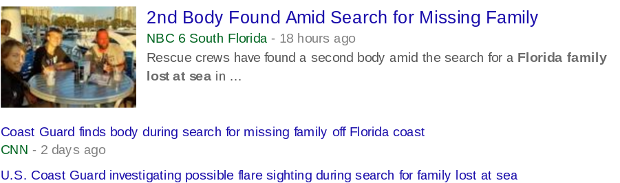
A small sailboat left port the other day with a beautiful family.
Every family's dream in Florida is to have a sailboat.
Many dream of living on said sailboat ..
Well.. those who don't motorboat or who are land lovers.


Heart breaking really. Happens.
Happens often. More often than a land falling Hurricane.
There were high seas. A regular storm.
Questions on the sailboat itself.
Rough seas and thunderstorms.
A bad decision. 
We all make bad decisions rarely are they life threatening.
I know a few I'd like to take back... 

Flash Floods in West Virginia happen.
History has shown that.
As stated on MSNBC this morning a channel I watch these days often..
Towns in that area sprang up along the rivers.
Every twist and bend of the river provided life.
Power for mills. 
Navigation and transportation.
Water the source of life.
And when the weather changes fast...
The flash flooding river can bring death.
Flash floods happen.
Even if in that guy on air says it never has happened in his life time..
...it has happened trust me.


A shopping area with a motel and hundreds of people are cut off ..
They spend the night last night cut off but alive.
A 3 year old toddler was washed away ...
Another little boy washed away in a foot of fast moving water died.
Five people are not alive.
Homes, roads and normal washed away.
There was no model driven discussion for five days out this could happen.
There was discussion of bad weather in that part of the country.
Think of it as a soft target weather wise.
We all worry on those big hard targets like Miami and Galveston.
We forget about the little towns near the bend in a river..
...we forget about Flash Floods.
Many in Miami and Galveston have Hurricane Amnesia ..

Everyone worries on hurricanes, twisters and earthquakes.
And yet it's the every day bad random weather stories that take lives daily.

Sometimes West Virginia gets Flash Floods from Hurricanes.

http://pages.geo.wvu.edu/~kite/2006%20Fall%20GEO493GHurricaneFloods.pdf

Other times every day systems moving East create localized flash floods.
Texas has that problem in Hill Country also.
The very lay of the land can be he hidden enemy.


A map of that area from Google.
A river runs through it.


So while worrying on the Dow Jones going down, down, down
530 points down as I write this...
Remember 5 people died in yesterday's flash floods in West Virginia.

Remember that El Nino is gone.
La Nina is coming on.

Are you prepared for a hurricane making landfall this year?
Do you keep your weather app on?
Do you know where your old fashioned weather radio is?
Do you check it daily for late breaking weather news of any kind?

While we wait to see how fast La Nina develops.
How fast the Saharan Dust fades away.
How fast the GFS and EURO get updated and revised...
While we watch every long range model going burp in the tropical night..
Are you watching the every day weather where you live?

Think about it...

It's more important than worrying if Invest 95L develops.

ft-animated.gif (720×480)

It might.
If it does I'll update the blog...

But today's real story is the uncertainties.
Uncertainties on the Hurricane Season.
Uncertainties of the Stock Market.
You can worry on the EURO models or the EURO union.

Don't forget to pay attention to the ebb and flow of life every day.
Think Global. Act Local.

Besos BobbiStorm
@bobbistorm on Twitter

http://money.cnn.com/data/markets/dow/