A writer and a tropical muse. A funky Lubavitcher who enjoys watching the weather, hurricanes, listening to music while enjoying life with a sense of humor and trying to make sense of it all!
Sunday, May 31, 2015
Worries on Weak System Forming in GOM or off FL? Sick of that "No Worries" Mantra
Is there something to worry on and where it is?
It's not the nice little low riding wave off of Africa.
The area today to watch is in the BOC
Tomorrow it might be in the FL Straits
Or... East Coast of Florida
Today:
A lot of oceanic heat content IF
a system forms there
however winds are not user friendly there
Might form somewhere else closer in
as Florida has the "OPEN" sign up for weak systems this year
For now the flow is strong in that region.
Lots of shear there.
The shear is not strong everywhere.. by the way
The good news is the flow across the region right now is fast.
The bad news is that may not last.
Where there is that much moisture it needs to be watched.
The GFS says a system may develop.
Let's get real a day away from the start of the 2015 Hurricane Season...
NO ONE pays attention really until the EURO says "I SEE IT!!"
Many of us like the GFS.
Hey it's the "AMERICAN" model
But, in reality, the it's all about the EURO
The EURO is watching but hesitant for now.
No the song for the day is NOT "all about..."
It is:
TOMORROW IS JUNE 1st!
Start of the Hurricane Season.
Often little weak storms flare up just to help the Hurricane Prep Game.
So... bring on a small weak maybe TS somewhere.
If it makes people take it seriously...
prepare...
as long as it's anywhere but Texas..........
Besos Bobbi
PS. RANT:
Just something to think on ...
as this is NOT a
"NO WORRIES" Year
Sick of hearing that stupid saying.
Sick of hearing people spouting numbers...
Sick of illusions of "no worries" when any year can bring a worry.
PREPARE like its gonna be a bad year.
Then donate the hurricane food (snacks)
or eat them and count the calories.
Now is the time to prepare.
Then sit back, relax and follow the NHC
And, your other favorite weather people.. like me!
1. Usually seasons that start early before the gun has been fired.. are typical of slow seasons. While this may be a slow season, it is not for the same reason.
2. Note the way that Danny formed out of an old cold front. Happens often. And, hurricanes that form close in are often more trouble than they are worth statistically as there is little lead time to warn anyone and as they are landlocked they are going to make landfall. With the set up we have had this year with the flow from the GOM moving, oozing north towards Houston, Nola and the Big Bend of Florida I would worry...
3. Things change in real time with weather and even a short term change can create the right ingredients for that "one hurricane" we will never forget........
With that tropical fetch already in place ...
...there could be trouble close in
And, lastly never forget it only takes one..
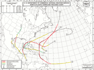
The "ONLY TAKES ONE" example:
1992
Map below . . .
A bunch of wishy washy Atlantic storms
and then........
ANDREW
Bulls eye Miami
A Hurricane to Remember...
Also remember some cities ..
...like Tampa...
...are more prone to be hit in "quiet" years
Let's go now to the current State of the Tropics..
It's a bit curious to have so much activity this early...
...tho to be honest talking quasi tropical
...but still it's there on the map...
There is a small window for some kind of development.
To look for discussion of the official kind it's best to go to the source and that source is of course the NHC. In their tropical marine discussion they mention it as an "upper to mid-level low" and why that is of interest is it has worked it's way down to the "Mid-Level" already. Could it work it's way down to the Lower Levels that we care about ... being a "surface" feature? Doubtful, but it's possible and would never say never when it comes to this 2015 Atlantic Hurricane Season.
So... as we work on our Hurricane Preparation for this coming season we are keeping an eye to the East of Florida "just in case" something grabs it's small window for development and shows up as an Invest at the NRL site. There has been some talk... but for now it's only talk and talk is cheap.
I'll tell you one thing I do find curious is the cluster of strong storms blowing off Gulf Coast states into the Gulf of Mexico. In typically "quiet years" we get strange named storms like Danny in 1997 from these sort of set ups. Something to watch off and on when strong weather is there... Again remember how fast that storm blew up by Dauphin Island and how fast weather turned wicked in Houston from this same system.
Besos Bobbi
Ps http://www.nhc.noaa.gov/prepare/ Now is the time to prepare as there is no reasoning with Hurricane Season.
Texas Flooding. Waterspout Bounce House. Analog Years ...Remember them?
Adam Bennet puts it right.
If you live in Houston.
Sit tight.
Don't drive
Unless it's an Emergency!
A satellite image shows the story better than any words can...
Look at the SIZE of that system over Texas...
Anchored there for now.
Again note that moisture from GOM keeps oozing north
into the area from Texas to Big Bend of FL.
Something to remember
as we move into the
Hurricane Season
I know your eye goes to the Mid Atlantic at that diving feature and the hook that looks like something is forming, but move your eyes to the left and see the blow up of storms over Texas that fueled the flash floods of Memorial Day Weekend 2015. Now look at the same water vapor loop of the Eastern Pacific and you can see why the Gulf Coast is in the flow for severe weather.
Note the moisture flowing Eastbound across the Pacific towards Southern California and Mexico. Also note to the south of that flow is moisture from tropical areas of moisture in the EPAC where their season has already started. It's sort of a 1 - 2 punch.
More tropical trouble could bring more Texas trouble
Short term more water
Longer term might help
Weather can be confusing.
Memorial Day Flood 2015
Before
After
On a personal note.
I've been offline for 3 days for Shabbos & Shavous.
I've eaten enough cheesecake & ice cream to swear off dairy for a year.
Living on Tagamet and watching TWC coverage of the tragic floods.
As usual Cantore does a great job explaining the details.
The devil is ALWAYS in the details.
Texas goes from drought to flood often
Flash Floods
Tropical Storms worse than Hurricanes
No name Tropical Storms
Hurricanes like Audrey
Hurricane Ike
This morning's blog is going to be on the dynamics of the flood and how it may or may not relate to this coming hurricane season. Also, the bizarre story of a bounce house that took flight on Ft. Lauderdale Beach when a waterspout suddenly picked it up and tossed it like Dorothy's house up into the sky Luckily, it was a small waterspout not a huge Twister that carried Dorothy to Oz. 3 children were injured and are home recuperating with a story to tell for the rest of their lives. Thank God they were not injured worse.
Many were injured worse in the flash floods and many have died. It's useless for me to give a figure of injured and dead or how many homes have been ruined by flood waters as the story is still unfolding. Just like we wait for morning visible imagery of a developing tropical storm we are just watching the first images from the air of WHOLE NEIGHBORHOODS underwater or damaged. I will update this blog later this evening with more sad details and hopefully information that could help someone along with some contrast and comparing this with other watery disasters that have happened in the Houston area. Note...this is being called the #HoustonFlood but it affected areas as far away as Austin and NOTE ...it is NOT over as there is more rain on the way. Though the totals may not be as high from the next rainstorm, ANY AMOUNT on top of what they have now currently could be the hair that broke the camel's back so to speak for many who woke up this morning thinking they may have barely escaped the disaster. It can and will change quickly again throughout the day.
It may be the FIRST Flash Flood Emergency for Houston, but it is NOT the first flash flood or emergency they have had there. This is rare and yet it's not so rare. The set up happens, this particular set up was huge vs localized and the Buffalo Bayou, used to flooding, flooded again as did most of Houston as cells trained across the area like a never ending choo choo train....
Going to do something I rarely do and hope my brother won't be upset. He lived in Houston for a few years. One year in particular he was caught out in a flash flood when the bayou reclaimed the land where homes and roads had been built. He described it to me at the time as one ocean wave just suddenly moving up the street and battering his windshield as he was trying to figure out what to do. This is a child of Miami, a young man who was used to record rainfall, hurricanes and tropical downpours and yet he had never seen anything like this.
"They're saying this is a 500 year event ... but yeah Houston floods ... flash flooding from time to time ... I went through one ... one minute you're trying to figure out which street has less water and the next second the water is coming in your car ... unreal ... and yeah south and south west Houston always ..."
Note his usage of the word "always" as flash floods in Houston are as common as waterspouts in Florida with it's long coastline.
http://www.floodsafety.com/texas/documentaries/index.htm
(A look back at flooding in the Texas area, recent and in the distant past)
Best place to get the news firsthand from Houston and other areas in Texas is straight from the source. http://www.khou.com/videos/news/local/2014/09/25/12651418/
I'll agree with him here. When you go to the beach in Florida you never know what you are going to see.
Really as a parent I can't imagine what it must have been like for the parents of these children to see their children go airborne suddenly without any warning of anything about to go wrong. Weather often goes wrong and it often goes wrong suddenly, especially in Florida. Houston is prone to flash flooding, though rarely anything like this, and sadly add in the Memorial Day Weekend when people are less aware of news and weather warnings. People are out at the beach, having a picnic, driving home from a basketball game or a school dance. There are no Hurricane Warnings being flashed across the TV screen for hours on end warning people how to properly prepare for storm surge, high winds and a possible tornado in a random band.
Flash Flooding means FLASH... in the blink of an eye, suddenly there is water every where and you often have no route to escape.
Waterspouts usually form fast, dissipate and are barely noticeable offshore as bathers point when they see it briefly spin up. Sometimes they don't even realize they were there as they form so fast and disappear as suddenly. Many a bather gets out of the water to dry off and someone tells they there was a waterspout and they respond "Man I wish I'd seen that" and then there are the larger than life TWISTER types that briefly end up on land, causing minimal damage and making the nightly news or youtube news or any news making people wonder why people live in Florida with all those hurricanes and waterspouts. The truth is in Florida they are usually harmless and we think of them as watery, dust devils dancing just off shore delighting beach goers that are lucky enough to have their cell phone nearby to snap a picture. Most storm chasers in the Florida area spend their time chasing waterspouts that form fast during severe weather events .... or suddenly when things change fast in the middle of the afternoon without a lot of previous warnings.
Note this waterspout in Oldsmar on Florida's West Coast. Pick a coast, sit a spell and you will eventually see a waterspout... hopefully you won't be in a bounce house . . . or a small canoe...
The best place in the Florida Keys to get great pictures of waterspouts USED TO BE the front porch of the National Weather Service before they moved from the airport to their fancy new digs. Some of my friends would take photos as they leaned into the railing and posting them online. Here's a link from the past with information still useful. Now they have to climb up the tower to get a good video of a waterspout, whereas before they were across the street from the Atlantic Ocean.
Moore, Ok 2 Years Later. How a Tornado Forms. Cantore Explains. Storm Chasers
A great video that is worth watching multiple times.
So much information.
Great graphics.
Well done.
I complain a lot about TWC as it's a sort of Love/Hate relationship for many of us. When they are good they are great, when they are bad they are awful. This video is excellent. Cantore doing what he does best.... explaining.
Reminds me of the hurricane at Margaritaville in Myrtle Beach... wonder if that's where he got the idea...
or his public service spot for Margaritaville or
"Hurricane Myrtle"
If you have ever been there you know how realistic it is..
..until Hurricane Myrtle goes to Vegas and then back to SC...
Seriously back to reality and the reality is the Plains are alive the last few days with twisters in Oklahoma. Due to a temporary set up that seems locked in place for a bit it has become a Storm Chaser Reunion on the anniversary of the Moore Oklahoma outbreak of 2013.
An excellent video that takes you back to that day in history when Moore got hit AGAIN by a devastating twister. People die. Storm chasers died. A little piece of a lot of people's hearts died that day...
Tim Samaras
A good video to watch to better understand the man and his mission.
Their mission.
They were 3 of the most careful chasers in the wrong place at the wrong time. That place being a massive traffic jam not of "chasers" but people on the road trying to outrun the twisters. Some on air local weather people suggested people could get in a car and escape a tornado . . . helping to create a panic on the road similar to the mess when people panicked after Katrina and half of Houston tried evacuating from Houston..even from areas not in evacuation zones.
Ever wonder what I look like while out there in the storm?
Truth is people ask me often "how can you go storm chasing?" or "why would you do that?" as I have done my share of storm chasing; hurricane storm chasing not twisters out on the plains. I tell them honestly I'd rather chase a hurricane than be chased by one. I'd rather be somewhere safe with trained professionals doing work that is shared and useful than be hunkered down in my house with my family about to lose electricity and praying the roof holds and we are all safe after the storm. Chasers know what they are doing out there and beyond our love of weather and being out in the elements we try to be as careful as possible to record and educate. Twisters scare me, hurricanes are easier as their movements are tracked over a longer period of time and like an 18 wheeler they take more time to turn then a small sports car. You can prepare for a hurricane, you can evacuate. Twisters have a little more lead time than an earthquake.
So in honor of this anniversary of the most recent Moore Tornado... it's good to learn the truth about them and understand them, respect them and respect all the people both on the ground, in the studio and behind the scenes who help us better understand and forecast tornadoes and other severe weather events.
Yesterday a line of strong storms with hail came through Raleigh. It wasn't a hurricane or a tornado but there was hail involved. It was short lived but fun to watch. As I'm taking video with the window open my daughter behind me says sarcastically "and she wonders why her phone stops working" Rolling eyes. Wasn't worth explaining the rain was coming at an angle on the other side of the car from where I was and the truth is I have never dropped a camera or phone chasing a storm, yet one fell out of my lap into a puddle when I wasn't paying attention I did once fall into the waves as Hurricane Floyd passed by Miami Beach... but I tossed the camera to the beach in time and got great shots. Wasn't far out... a little bit, so I got wet. Got great shots :)
Hey she's not one of the storm chaser kids and yes loving weather runs in the family be it genes or upbringing. Note she is NOT the daughter I went chasing with in Bayswater as hail moved in and shut down JFK. We raced over to Long Beach to catch the line as it passed through there and my other daughter grabbed my camera and snapped the shot below . . Daughters... love them all. I even have one that is ?? terrified of thunderstorms ??? and another had to sit by the canal a little longer before we shut down the house for a hurricane...
Note... one of the first songs I ever remember hearing...
...was ...
Somewhere Over the Rainbow...
explains a lot
Besos Bobbi
Ps 10 days to go to get out of May before we move from Pre-Season to Hurricane Season on June 1st. If you live in Hurricane Country NOW is the time to make a plan. If you live in Tornado Country...hope you already made a plan. And remember tornadoes unlike hurricanes can happen anywhere.
Location: Miami, Raleigh, Crown Heights, Florida, United States
Weather Historian. Studied meteorology and geography at FIU. Been quoted in Wall Street Journal, Washington Post & everywhere else... Lecturer, stormchaser, writer, dancer. If it's tropical it's topical ... covering the weather & musing on life. Follow me on Twitter @ https://twitter.com/#!/BobbiStorm