Hurricane Harbor

A writer and a tropical muse. A funky Lubavitcher who enjoys watching the weather, hurricanes, listening to music while enjoying life with a sense of humor and trying to make sense of it all!

Saturday, August 31, 2013

It's September... Tropical Possibilities... Invest 97L Near the Leeward Islands


It's September...wake up and smell the tropics!

Sort of like "Hello...who are you?" and "why are you here in my part of the world??"

Note that the RED area is close to the Islands where the wave that is now Invest 97L not over Africa. Though it does show a ripe area for development in the favored area of the ITZ in September which is now!


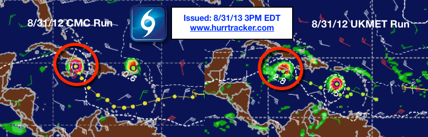
Let's look at the model that started all of this on Friday..the Canadian today


[JavaScript Image Player]

New Canadian Model brings a weaker storm further west and closer to South Florida after crossing Cuba. Where will the next model run take it?  Either way worth noting it is still developing the Central Atlantic Wave now known as Invest 97L.

It develops it after moving into the Eastern Caribbean and then takes a sharp right turn up towards a strong cold front. My problem is that it's an awfully sharp turn for a weak storm. IF it was well developed it would want to go more to the North and the front is forecast to be strong. Also, there is convection in the Western Caribbean so why would a weak storm not continue west. There is also discussion that it might have a multiple center and the stronger center is further East or might relocate under the stronger convection as currently the "center" is west of the real convection.

http://moe.met.fsu.edu/cgi-bin/cmctc2.cgi?time=2013083112&field=Sea+Level+Pressure&hour=Animation
Loop it please.

(Note updating this before I go to sleep and the NEW model takes it up into the Atlantic again...as a stronter storm...below)


Remember when I wrote about this on Friday few people gave it any attention and everyone was staring at the Eastern Atlantic at a system that was supposed to develop fast and move NW and recurve before getting to 45 West.  Be aware it hasn't and if it hangs around it could get further west than the usually reliable models were predicting. The models have not been that spot on this summer, especially the GFS that did make several good calls but has also made some poor ones...especially long term. It has stayed conservative in not developing waves into hurricanes and on that basis it's still every one's favorite model. Well, most people's favorite model.

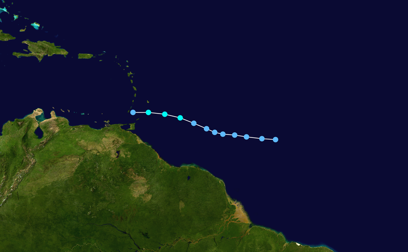
So, let's look at 97L up close and personal.

Click to unzoom

Approaching the islands.

20130901.0215.goes13.x.ir1km_bw.97LINVEST.25kts-1009mb-150N-569W.100pc.jpg thumbnail

Let's stick for now with black and white ...


Notice the Upper Level Low to the NW of Invest 97L. It has a finger that reaches far to the ESE and "tickles" Invest 97L which responds in a fit of giggles by blowing up and showing us more convection. Upper Level Lows can tear a tropical wave apart if too close ... but it can also give it new life if stays nearby but a safe distance away.

I also want to point out that this is happening in the Western Caribbean as well to some degree. There is an ULL in the Gulf of Mexico. The Caribbean has been looking as if it could support development of a system for the last few days. Something is going on down there and if this trend continues.. if a drop of High Pressure builds a lot and the ULL stays to the North or NW... something could pop.  IF Invest 97L got there in a few days...  if it doesn't follow the ULL over PR and DR WNW under a high pressure ridge that is slowly being eroded by repetitive frontal boundaries pushing down into the Carolinas and into the Westernmost regions of the Atlantic.

Look at this chart that shows us how HOT the Caribbean and parts of the Bahamas are IF something wicked were to come their way.


A lot to think on.

This is September.. remember that.

In 1988 there were no hurricanes until September 2nd...and then there were several Major Hurricanes including Category 5 Hurricane Gilbert whose name was retired after killing over 300 people.

"Hurricane Gilbert was the most intense hurricane ever observed in the Atlantic basin until Hurricane Wilma broke this record in 2005. The storm caused $5 billion (1988 USD) in damage across the Caribbean and into Central America. Gilbert was the first hurricane to make landfall in Jamaica since Hurricane Charlie in 1951. Until 2007's Hurricane Dean, it was also the most recent storm to make landfall as a Category 5 hurricane in Mexico. The death toll from Gilbert was reported to be 318 people, mostly from Mexico."


Then there was the very strong Category 4 Hurricane Joan in October which wasn't all over.. after a dismal start of small no neck tropical storms and depressions after a very quiet August.


Sort of similar looking aren't they?

The season as a whole is here:


The loser storms of the season were Tropical Depression #5 that fell apart and then was tracked again later. Sound familiar?

File:5-L 1988 track.png

Isaac fell apart...

File:Isaac 1988 track.png

Now...why did Isaac fall apart and TD5 never got the E name ..though I bet in today's more liberal culture of naming systems it would have been the E storm.

And, more so...why did Gilbert intensify and not look back and Joan almost made Category 5 after a quiet August?

Because....................things change in the tropics. 

Today we are looking at a wave that is viable and staying alive about to come closer to the islands that several models refuse to ignore even though others do. An area of convection in the Caribbean that  no one is talking about and an African Wave that didn't develop fast into a storm and whose chances went down not up over the last 24 hours. I don't have to remind you if it hangs together it could get further west than 45 and it could miss it's ticket for early recurvature.


And, by the way..................it's September. If not now when? Okay, possibly October... like Joan and Wilma and notice they were both strong storms but one was in a busy year and one in a quieter year. They both did massive damage.

From Wikipedia "Hurricane Joan killed 148 people in Nicaragua and 68 others in affected nations"


Bigger view ....


So, based on models that were WRONG... on Friday we were staring at the Cape Verde Wave expecting it to get a name on September 1st and stay in the East Atlantic outlining the African coast. The wave in the Central Atlantic was made fun of by EVERYONE except those who love to watch the Canadian. 

36 hours later the chances of the African Wave for development by the NHC are way down. The chances for the Central Atlantic Wave are up so high that it has it's own Invest.

How things change..........  and why you can't simply rely on the models. And, in my position I am not going to just parrot back language I read in the NHC discussion and rely on the models to only look at what the models tell me might develop... especially in such a strange year as 2013. Strong frontal boundaries and the 3rd highest rainfall total for June for North Carolina EVER.  It's just an odd year and the models are not perfect and they change every twelve hours or so. It's sort of like a girl with a period every 12 hours vs every 30 days. You want a dog in that fight? I don't think so......and yeah I'm a woman I can say that. Hurricanes should be female named storms for a reason. Maybe Upper Level Lows should be male. How many of you are glad you didn't give up on this post three paragraphs ago. Seriously...some models change their mind so often you need to sit back, watch and enjoy the drama when they are not developed and far from land. These are though tell that to the islands.


Ouragans.com · 8,919 like this
2 hours ago near Les Abymes, Guadeloupe · 
  • Bulletin #MétéoFrance #Martiniqu

    A 20h30 le niveau de vigilance est vert pour notre département.

    L'onde tropicale est encore loin: ce soir, elles se situe à environ 600 km à l'est de la Martinique.

    Les nuages défilent en ordre dispersé. A chaque passage, quelques millimètres de pluies sont déversés, ici ou là. En mer caraïbe, un ou deux orages pourront encore se développer, et il n'est pas impossible que l'un d'eux se fasse entendre sur l'île.

    Les alizés de nord-est sont faibles, entre 10 et 20 km/h, sauf au passage d'un grain où ils accélèrent à 30 km/h.

    Quant à l'océan, il est peu agité, avec des creux d'1m10 en moyenne. La mer deviendra agitée en Atlantique et dans les canaux, elle se creusera vers 1m60 en seconde partie de nuit.

    Prochain bulletin demain matin à 5h30.

Yeah, there's a big world out there between South America and Florida and the English speaking countries.

A good look from a great site.


It's a BIG blue world out there. Tomorrow the models may love it or hate it or take it into the Carib or Carolina or show it falling apart. But, again this is an excellent example of over reliance on the models in that we are watching a very alive Atlantic wave approaching the islands, but based on modeling no one wanted to pay attention and were ready to name the next storm out by Africa.


As my friend who has passed on Harvey used to say "where's the pain now" after he would work on me. I ask "where's the next possible named storm?" and remember it's not where the models said it would be less than 48 hours ago.

Will the Invest 97L survive? Only time will tell.............but there are subtle changes in the tropics on the 1st day of September vs the quiet time in August. And, remember... the first named hurricane in 1988 was on September 2nd...and the neither Gilbert nor Joan ever looked back.


Besos Bobbi

Ps............it's such a big world you can even include in outer space.


Weather there too...

Friday, August 30, 2013

Hurricane Chatter Online on Possible Hurricane Threat Next Week to East Coast


Okay... decided to post on this because people online are going crazy and getting excited due to a few models that develop the Tropical Wave into a storm that moves north towards a Cold Front in a weakness in the Ridge towards the Carolina Coast and the rest of the Coast beyond that...........

Possible for CLIMO though any attempt at getting such a storm rolling this year has been batted down by one feature or another.

Here's the link... note that it intensifies over the North Coast of the Dominican Republic where many a weak storm fell apart so far this season ...but that was earlier this season.

http://moe.met.fsu.edu/cgi-bin/cmctc2.cgi?time=2013083012&field=Sea+Level+Pressure&hour=Animation

What I find interesting is that the signature of this supposed storm bears a close resemblance to Fran from 1996.  Earlier this year MANY times I pointed out that the record rainfall in North Carolina goes back to records from 1996 the year when Bertha and Fran hit an already water logged region.


September 8th from a model... far, far from a sure thing... just a model forecast.
Like the ghost of Fran


Fran is the bottom storm and the model signature for both rain and wind over the Carolinas into Virginia would be very similar.

NO.. I am not saying this is Fran #2 or Irene #2 as some of suggested. I am saying patterns exist.

For the Almanac aficionados... it does show hurricane problems in September and by the way..it also showed NONE in August. Well one way off shore, but no threats.

Note threat for the 7th and this model is for the 8th... could recurve or stay off the Outer Banks. .IF it forms.

September 2013
1st-3rd. Scattered showers may dampen holiday plans, then fair.
4th-7th. Hurricane threat along the Atlantic seaboard; otherwise generally fair, very warm and humid.
8th-11th. Thundery conditions.
12th-15th. Showery rains spread to the north and east.
16th-19th. Thunderstorms along Gulf Coast. Rain for Tennessee east, then fair.
20th-23rd. Hot and oppressively humid.
24th-27th. Fair, turning much cooler for Mississippi Valley east.

28th-30th. Widespread showers for most of the Southeast.

http://www.farmersalmanac.com/long-range-weather-forecast/southeast-us/

Just find it interesting that the only threat for September is during the time period the Canadian and another model are screaming formation and landfall threat.

Neither the GFS or the EURO show this happening. IF either of these A Team models even suggest such a storm you will see Invests and discussion on TWC nonstop. Hey...got nothing else to talk about other than old clips from the 1935 Labor Day Storm.

Chatter online from reliable sources:

28 storms...
https://www.facebook.com/photo.php?fbid=661889100490267&l=689ceaa642


https://www.facebook.com/photo.php?fbid=10151780775827367&l=aaf43351f4
Mike's Weather Page on Facebook.

https://twitter.com/Jeff_Piotrowski/status/373530568547258368/photo/1

Note yesterday it was there but further to the East... getting closer to the west and the East Coast today.
Yesterday:

http://www.tropicaltidbits.com/analysis/models/gem/2013082912/gem_mslp_pcpn_atltropics.html

Just saying..................tomorrow is the last day of August.

Let's see what September brings... and you know that saying September Remember...

Hurricane Fran.. September 5th, 1996...........

Besos Bobbi


Going into Larbor Day.. No Hurricanes Anywhere in the Atlantic. Yellow Circles & Tropical Thoughts


Nothing has really changed. There is still a circle in the Central Atlantic with low chances of developing and a circle over a beach in Africa for a wave that might develop and turn NW rapidly and never reach our side of the world. Mind you if it makes it across the ocean and threatens the Carolinas it was the models that said it would be a fast recurving fish storm. I'm not taking any personal responsibility for a long range forecast for a wave that is not totally in the water yet. But...the set up would support that IF it comes off spinning and stays spinning.


I'm going to discuss the African Wave which is an Invest already and explain to you why it's possible it's got more problems than the forecast implies.


This particular satellite image is the best to show as it shows the round, concentric, white ball of what should be our next Tropical Depression. That is "should" in theory and my crazy friend I love told me never to say "should" so ... it's probably but not a for sure. The spotted clouds to it's immediate NW are DRY clouds and filled with lots of little reasons that this is not such a positive environment for Gabby to take her first steps. Note the red curving lines down to the SW would be her bands should be develop and again not that the only place for moisture is to her south. There are some dots on the in the white mass...but not a lot. This is not a solid "Go for lift off" here..

But, when a storm has those legs and that are more like a mermaids tail that help propel it across the ocean that could give it a moisture feed.. you don't want to count it out. Also, pressures are low enough for the NHC and NRL to run models on it.

The models make it a "Fish Storm" of the African kind vs the local kind. It doesn't have to get to a weakness in the ridge, it misses the ridge and turns before it ever sees it.


Now one thing I do want to mention is that the GFS now has it turning just before 50 and earlier models had it turning way before 45 so... always pay attention to the trend. Each model run gets this Low that is currently still over Africa further out into the ocean. Again, it's not as good an environment as earlier models would have you believe and that could account for the slower development and the further models being currently further to the left.


Now, the Central Atlantic Wave which is a real puzzle on some levels. This wave should (oops) be developing in late August in that area of the Atlantic. Between water temperatures and CLIMO and synoptics there is no real reason that it isn't stronger. It flares up, it falls apart and then it flares up again.

[JavaScript Image Player]

This is the Canadian Model that everyone loves to bitch about...but always looks at it figuring it will spin up a hurricane if it can.  It develops it logically coming into the islands and strengthening and then moving towards a cold front to the NW and a weakness in the ridge that would most likely in other years show us a hurricane moving towards the Carolinas and then curving out by the Outer Banks out to sea. Yes, that was a long sentence..

It's also a long shot.

The GFS model which is the current darling of all the models does not show anything like that happening. May I remind the GFS that the AVN was once the darling and Prom Queen of all the forecasters and then the NOGAPS and well... another one is for sure waiting in the wings and we will laugh at the GFS one day.

http://moe.met.fsu.edu/cgi-bin/gfstc2.cgi?time=2013083006&field=Sea+Level+Pressure&hour=Animation

What I find MORE interesting with the GFS is that around 120 hours it totally shrinks the High for no real apparent reason which makes me feel that something is off with that. And, it stays shrunken for a while which if we have real hurricanes would leave the door more open to a landfall on the East Coast ...except that there are no hurricanes anywhere.


So, I ask myself..."Is that normal or believable" and the response in my gut is "NO" but, then again things seem to be shifting. The Lows on the NW side can erode it, and maybe a strong hurricane from the SE can erode it there, but just seems a bit too overdone on the weakness of the high..or shifting of the High towards England...  Okay, exaggerating a little but watch the loop below.

If you look at the 7 Day NWS Loop you will see the cold front, though it's worth noting it sort of falls apart over South Florida. It's also worth noting it GETS to South Florida. Not normal for this time of year..

http://moe.met.fsu.edu/cgi-bin/cmctc2.cgi?time=2013083000&field=Sea+Level+Pressure&hour=Animation

Now look at the 7  Day NWS Loop.

http://www.hpc.ncep.noaa.gov/basicwx/day0-7loop.html

Note on Thursday, September 5th it shows a weak cold front sliding off of South Florida. IF a storm was to the South somewhere it would be a magnet to pull the storm to the north. Now think on this part. Here we are going into Labor Day Weekend and it's a BIGGER IF on the development of a hurricane than the development of another Cold Front which is a sure thing betting wise. Is that normal? No...

Go with the flow and what is happening now this particular year vs CLIMO I guess. This is one of those years that breaks the rules.


What's the nail on the coffin here tropically speaking.  The next frame in the loop shows ANOTHER Cold Front about to descent down again. This is what you call a "pattern" and it's been going on most of the summer and we are edging closer to Fall when there will only be more Cold Fronts. Yes, a week or two of Indian Summer will exist... probably ... who can say for sure this year?


The following day on Friday a new Cold Front moves south across Virginia and the Carolinas.

And, this pattern is why I say that if the Caribbean gets active later in the season like it so often does it will be a classic set up for Tropical Storms and Hurricanes to be pulled North..sucked North... attracted North or even Northeast towards landfall along the Eastern Gulf of Mexico and South Florida. Because the pattern ain't changing and the reason that storms did not form in the Caribbean is not the same reason they did not yet form in the Atlantic. It's the same "basin" officially, but two birds of different feathers or maybe brothers from a different mother. Mother Nature is tricky at times..

There is a small roll in the "juice loop" around 50 West where you can see the 10% yellow circle is TRYING to develop somethingm but it keeps losing it's mojo. 


Speaking of MJO... it's moving into our part of the world, however the signal may be weaker than normal and not as good of a definitive hurricane maker.. weak tropical storms maybe.

A low pressure system formed off of the coast of Carolina yesterday and is swirling up and carving it's way into the Northern side of the Bermuda High. Another swirl up ny Nova Scotia says a lot. No swirls, tropical depressions or storms or hurricanes are in the tropics and even wishcasters are quiet taking Xanax and playing Fantasy Football.

I cut and pasted this from Mike's www.spaghettimodels.com page as they work well together:


Above:
Still shows the Central to the Eastern Atlantic Hot to Trot for Tropical Development.

Below:
Shows the Eastern Atlantic a prime piece of real estate for Tropical Development.

Reality Bites with the NHC Graphical Discussion:


That's all for today. An ULL is anchored, rooted to the Southern tip of Florida. When that chances give me a call... send up a flare.. fly a banner plane over my house :P

Visible Water Vapor - GOES East 12 hr Loop

The Water Vapor Loop does show the battle for the Western Atlantic between fronts, lows and the Bermuda High. Keep watching. It's the only show in the tropics as we move into the Labor Day Weekend.

As for me personally... 

I'm saying goodbye this week to a couple who is moving to Israel from Raleigh. My older daughter is in town and we are walking and cooking healthy food. My younger daughter is at college getting ready for her first NC State Football Weekend... shabbos, life goes on.. etc.  And, I'll be at a Farmers Market somewhere buying fresh apples to dip in honey later in the forecast period. Maybe a drive somewhere pretty.. to the coast or to the mountains or just out in the country. Who knows? 

One thing I know.. won't be tracking any big hurricanes going into Labor Day Weekend......then again 3 and 4 days before the Labor Day Storm of 1935 there was nothing out there also..and then there was...

Besos Bobbi

Ps...

20130830.1145.goes13.wv.fd.x.jpg image

Thursday, August 29, 2013

Circles in the Atlantic... Memories of Katrina and What I want in a Cell Phone & NHC Trying Hard to Please..


This image should update in real time so if you look at it 3 days from now and it shows a hurricane or no hurricane or a Zero% chance that is why it's not in sync with my discussion.

Another image is below that will stay the same. It is a little experiment on  my part of compare and contrast the yellow circles.


The image above is a memory set in stone of how the tropics appeared on August 29th at 10 AM as is the image below... which shows more areas to watch..


This is why I said they should draw a large yellow circle over a wide area...because there are multiple areas that may or may not develop.

Now days the NHC is trying to break up their graphic forecast maps into parts. A little too left brain if you ask me with some right artsy brain thrown in.

Remember the yellow numbers are short term, the long term percentages are in the discussion.

The area furthest west getting close to the Central Atlantic has a 10% chance now and a 20% chance of developing down the line:

Click to unzoom

Click the link above for their discussion.


Click to unzoom

Click the link to read their discussion.


The circle over Africa has a long range 30% chance of developing.

I understand what they are doing and I think it's good, however it's not quite right yet. It needs some work, but it's a good idea and helps analzye multiple areas that could be highlighted in the middle of September. At times it reminds me too much of those sites you don't want to read through that say "Top Ten Cities to Live IN" and then you have to click on a link (with loads of spam features) and then click on #9 and then #8 and well you get the picture OR... like most of it you pass and don't click on any of the links when you realize you are going to have to go through 15 screens to find out what could have been put into one list.

They are really trying hard to keep up with the technology level of the average viewer to their webpage. In the world of APPS and iPads and multipurpose phones that do everything but take a leak for you.. and now they are going waterproof for the set who is continually texting on the toilet and dropping their phones in ...    the NHC is trying to provide information for everyone on a constantly moving target. It's not archery, which is what they would prefer. Bullseye...this is the system... 10%... check back tomorrow is what they would prefer. But, people want more and more and more these days.  And, that's not bad, but it's hard to figure out the best way to make everyone happy these days.

It's like telephones (stick with me here) ... you know cell phones...  fones.......... unless you are a loyal lover of one platform or another it's a big decision. I'm an Independent voter.. no D nor R nor even a L on my voters registration.

The iPhone is nice but Lord have mercy you spend your whole life hitting that middle button to do anything. For years I wanted one badly and now that I can get one... I don't think I do. Yes, it has great applications, but that's not my focus. And, speaking of focus.. I want a phone with a button on the side that allows me to bring up the camera immediately. Obvoiusly Focus on a Fone is what I want... I also want Gorilla Glass and the iPhone doesn't have it so now they have reinvented the wheel and everone is running around with a big brick around the phone as most people have shattered their screen numberous times.  Add in a place for your credit card and keys.. it's getting sort of ugly unless you like ugly and the whole idea of the smooth, sleek, sexy looking iPhone is now lost as it's become the heavy weight you carrry around as it no longer fits easily where it used to.

That was how it was sold in the old days.


 Then the 5 came out... longer but not wider... oh so sexy..........


This is how it looks on YOU.................  in an otter box of one type or another...


Sort of like the way women who are sexy and beautiful and a size 12 look at models who are a size 0 wearing outfits that do not look good on the average woman...but look great in the magazine. Real women have breasts and that cute empire waisted mini dress on a busty woman makes her look very busty and 4 months pregnant. If you have no shape and you wear them you look cute, sexy... delicate, appealing. They are not made for busty women.  And, that is why if you don't give us a V neck tee shirt we are going to take a szizzor and cut a line down the middle so we can breathe and look cute....

Models are for the runaway....

The iPhone is no longer sleek and sexy, because people are getting tired of replacing them and are buying into the otter box which I do not want... maybe purple on the outside and hurricanes on the back but no really unless I am using it as a clutch purse like my almost daughter-in-law does I'm no longer in love and I think not. Maybe.

http://www.youtube.com/watch?v=UM6PBhHz3qY


Windows Phone............I really do want this phone and most likely will get it. I want something different, colorful, fast and a good camera and it has all of that in one sexy thin box which does have gorilla glass and won't look too big when I put a protector on it.


Nice.. I can make the tiles purple :) it has a button on the side for pictures..  it has a kick ass camera. I can customize it and it has enough Apps or APPS or however we spell it for me. I really wanted the blue one not the silver fox one............ petty I know. I'm both right and left brain which is my problem. It's big...another problem as I have small hands.


The Galaxy S4 is a little big for my very small hands, it's easy for me to use as the SWYPE works well on it, but it doesn't have the dedicated button and no I don't want to hack my own phone.

I also want a phone I can type on with less stress than correcting the mistakes and no do NOT tell me I don't want this phone because I do...


It's light weight, has a good battery, works fast and yes I do know it's a Blackberry and yes I heard they are for sale and it has a keyboard and a camera and it's fast and light and fits in my hand.

Big decisions and after using an old phone temporarily with a real key board I have to tell you I love it and am not constantly freaking annoyed because I don't get the word Terri for the word "there" and seeing as I don't have any Terri people in MY life and have not typed the word Terri before I don't know why my phone always wanted to type it. And, there is a long list of words I compiled that ...by the way... I never type that my phone keeps trying to type when on the setting showing my vocabulary (are you reading this currently now...) anyway...

The NHC's new delivery platforms and adjustments to their page is like me trying to choose a new phone. There is just so much out there available and they are trying to keep up and I know that if I wait two months there will be a newer Windows Phone and Apple has an announcement next month to possibly fix the problems with the 5 that people are bitching about and the S9 should be out faster than you can say "Sam you made the pants too long"

What do I want?

A phone that is fluid and easy to type on and has options of a real keyboard.
A camera button and a drop dead great camera.
A phone that does not break when I drop it and smash into smithereens that cut me.
A phone with a long battery life.
A phone that is fun, different and uniquely me.
A phone that doesn't weigh too much and doesn't need to go on a diet, but not one that is too thin.
A phone that fits in my hand.

Back to weather.....................

Another great map the NHC has come up with that Mike has put on the front page of www.spaghettimodels.com is this one.


Ha! Did you hear ANYONE talk about that tropical wave getting near the islands today on TWC? I bet not.


I've mentioned it a few times. It's there and should be watched even if nothing will come from it.

Another wave to watch OVER Africa is this one.... because the lead wave will spin up fast and most likely go too far North as it will be overdeveloped way too early and not giving any examples that I could give of what it is like to be drop dead gorgeous at 14 and look like you are 24... you get burned out too fast sometimes if you know what I mean.


The wave behind the lead wave with the 10% chance has a larger, huge pocket and might stay more to the south. Maybe.

Maybe being the word of the summer of 2013.

Maybe we will have a very active hurricane season.
Maybe we are starting winter at a record early point.
Maybe we are going to have one hell of a hard winter and TWC is going to have to go through 2 alphabets to keep up.

Maybe I'll make up my mind today or tomorrow on which phone to buy. Either way I have a whole lot of pictures I want to upload and go through from this one and I am actually enjoying typing rather pretending it's normal to type on a glass brick that is now being engaged in a HUGE FORTRESSLIKE OTTER BOX.

And, maybe I will write a long blog on Katrina which is another case of living in denial. 33,000 people were evacuated after Katrina not because Katrina was a big, bad ugly storm, but because 33,000 PLUS people lived in denial that one day a storm would take out the levee that everyone knew was going to fail one day and that one day a storm would hit it just so and wipe everything away.

Denial. The government knew both locally and nationally speaking that the levees were not going to hold. But, people lived there. And, people love living in New Orleans and ONLY the area in the French Quarter is high and dry during a storm which is by the way WHY the early settlers chose it after learning the hard way that bayous flood. The same way the early settlers in Key West filled in the mosquitoes infested ponds which were near Duval Street and moved the cemetery to higher ground after the graves were washed away in an early storm. Flood plains flood some day. Ocracoke is stunningly beautiful... it gets washed out and over in a big hurricane. Miami is built at the edge of the most beautiful Biscayne Bay that will one day carry a storm surge towards Brickell and do billions, trillions of damage and people who live in denial will get washed away if they don't evacuate.

We all live in denial on various levels. Pretending you can type on a glass brick is a game of denial. It works, you manage but it's not easy or fluid and it's annoying as hell. Which is why they made Siri... Now do I really want a long term relationship with Siri in my life? Hmnnnn..


So that's the state of my tropics and my life today and the 33,000 people who should have been given better ways to evacuate the 9th Ward and other areas are no different than the Vets who should never have been left down in the Florida Keys with water on each side feet away from their camps in the 1935 Labor Day Storms.  Yes... the worst case scenario happened, but still someone..somewhere failed those people. Maybe we the media failed them because the Mayor New Orleans said IF you stay write your social security number on your body so survivors can figure out who you were.......and keep an axe with you to hack your way through to the roof top for a chance of surviving and for some reason it was not played up as much as it should have been.   Denial....

Have a great day... watch all the videos on Katrina and if you live near a river that once flooded know it will flood again. If you live near a fault like like the New Madrid Fault.. know it will become active again. If you live in Tornado country you may see a Twister and if you live near the ocean  know a storm surge may come and wash it all away.

BobbiStorm's Bottom Line:  Enjoy what you've got while you've got it and know that things can change any time and it will be gone. Don't live in denial... appreciate what you have.. love the river and the mountains and the forest that can catch fire and smile and say "thank you" to those you love and enjoy what you've got and make sure those you love know you love them.............smile more, frown less and give thanks!

Have a great day...........................

Besos Bobbi

Ps...See how happy I am when there are no Zero Percent Circles on the map and I have two daughters I adore near by :)

Wednesday, August 28, 2013

Cape Verde Islands Wave - - 10% Yellow Circle


About time.


Part of the problem currently is that unless a model shows a storm forming and developing deeply the area of interest is ignored. It reminds me of when we were all online in chat rooms. If a wave was beginning to develop enough to get an Invest and then models were run and it showed the storm was either going to fall apart or recurve and immediately no forecaster, tracker or chaser wanted to talk about it anymore. If it's not going the distance... it's ignored.

That's now the current mind set it seems. If it's not going to do much... it's ignored. Unless of course it's about to hit Mexico and then suddenly it's upgraded two hours before landfall.

Yeah, it annoys me. I like consistency and there has been little from my perspective over the last ten years or so at the NHC. Without consistency how do you compare the data from year to year. It's easy to argue that now that we have better satellite surveillance than we used to have we can see when a circulation has formed or hasn't. Yes and no. It's true to some extent, but there are many storms in the last few years that would never have ben upgraded by either Bob Sheets or Max Mayfield.

I respect what they do enourmously... I'd just like a bit more consistency.

We live and die by the mdoels these days, but often the models are off for some reason hard to figure out until post season analysis.

The area is there...it has convection and spin and it deserves a yellow circle and possibly a NRL Invest down the road. We spent a week staring at nothing named 92L because the models were slow to drop it.

I like brain power and savy of forecasters who have experience to blend their own wisdom with the wonderful models to give us a better picture of what may or may not happen in the next two weeks.

I'm a little spoiled. I've known some incredible forecasters personally and they didn't have to wait for 2 or 3 days of modeling packages to follow a certain path before telling me that a wave off of Africa was going to recurve or slam into Wilmington, North Carolina.

Currently we are all talking about the MJO moving into our part of the Atlantic Basin. It should do for the Atlantic what it did for the Pacific.

http://www.cpc.ncep.noaa.gov/products/precip/CWlink/ir_anim_monthly.shtml

Your homework is to study the link above and remember it for the next few days. Watch the green lines not the brown ones ;)

200 hecto Pascals Velocity Potential Anomalies

If a high forms a loft somewhere or an Upper Level Low decides to take a hike or a sabbatical...something somewhere will spin up soon.


1950 was a slow starting season. The first storms formed in August. No early May or June storms. An active busy year later in the season.


Let's look at the K storm... K for King.


Three Category 3s
Two Category 4s
One Category 5

Just because we don't have a Larbor Day Hurricane this weekend (Thank God) don't think the season is over!

I've been worried for months about an active October for South Florida and mentioned it here before. Strong frontal boundaries will suck anything up towards Florida.

So...keep watching the tropics.... and keep watching those models...they will start changing.

Meanwhile I am sort of finally unpacked. Finally settling in. I was over at the college tonight with my daughter who is there and my daughter who just came down from New York to visit.

This is Our State. This is Your State. Go Pack!
(I spent a lot of money for orientation to learn that ....)


This is Our State... we are the Wolf Pack.......  lol. It's sort of like mind control. Nice to be back home.

Every state is going to have a great Labor Day Weekend including the beaches so make your plans, pick your beach and enjoy the quiet times.

Sweet Tropical Dreams,

BobbiStorm