Hurricane Harbor

A writer and a tropical muse. A funky Lubavitcher who enjoys watching the weather, hurricanes, listening to music while enjoying life with a sense of humor and trying to make sense of it all!

Friday, August 31, 2012

Isaac's Terrible Aftermath Dam Failure & Leslie Inches More & More West

Very tragic situation developing regarding the dam failure. Understand this is far away from any area that was told to evacuate and though they were told there would be a lot of rain, no one expected things to play out this way.  The dam that is failing was scheduled to be repaired later this year...

Short on time and long on concerns.

Donate now to www.redcross.org as there are so many people who will be needing their help and ...or ..the help of any other local charity that you would like to give.

Also, there are still many areas with high water that are flooded and the death toll is expected to climb.

As for Leslie... she keeps inching closer and closer. Getting bigger, stronger and on her way to her possible Major Hurricane Status later this week.

http://www.ssd.noaa.gov/goes/east/tatl/flash-vis.html

She is no longer out by Africa and she looks more and more like a Cane as time goes by.


What is the NHC waiting for...recon??

Also, be aware that the 5 PM Cone is to the right of the Model Consensus. It is less important in my mind that the previous forecast verified than the most accurate data is given to the public. Again, a week before Hurricane Isaac hit the bayou country to the South and West of New Orleans the models were calling for a hit on Miami and many models took the storm far to the right through the Bahamas. A week out is very, highly inaccurate and Leslie may be a Category 3 or 4... not a weaker storm like Isaac. Keep that in mind. Also, size wise she is big.... like a 53 foot tractor trailer hauling tons of tropical moisture with her on her road trip across the Atlantic.

Quote from the NHC below.. also...those cities in the Islands still have a 34% chance of having tropical storm force winds...despite the official "out to sea" forecast.

If you look at the NAVY map you will see why... the left end of their "cone" hits 70 West.


THE OFFICIAL NHC PREDICTION
IS SHIFTED WESTWARD TO COME CLOSER TO THE DYNAMICAL MODEL
CONSENSUS... ALTHOUGH THE MODEL CONSENSUS IS STILL A BIT WEST OF
THE NEW FORECAST.  


Warnings for the dam area and other nearby areas also affected:

http://www.srh.noaa.gov/lix/

The Percy Quin Dam upriver from Kentwood is about to fail... people are being evacuated.

http://www.nola.com/hurricane/index.ssf/2012/08/mandatory_evacuation_being_con.html

map-percyquindam-083012.jpg

Not a good situation.... please pray, please send money and donate as you are able to help the people affected by this terrible tragedy.

Be back tomorrow evening with more info on both the aftermath of Isaac and what should by then be Hurricane Leslie.

Besos Bobbi


weets Top / All / People you follow

DEVELOPING STORY: Mississippi dam threatens to fail; Mandatory evacuation for 60,000 
Video Extra: Isaac Flooding Concerns May Cause Dam Failure - A controlled release of a dam along Lake Tangipahoa in ...

Concerns on Isaac's Future Track...


This is Leslie, a very strong Tropical Storm that looks more like a wannabe Hurricane. Leslie looks stronger at this point, than any other systems  did so far this year when they were struggling out in the middle of the Atlantic. And, she is getting stronger and not struggling with the problems that Isaac and Ernesto had to battle.

And, the models STILL show Leslie sitting in the middle of the ocean a week or so from now, spinning and doing loops...  no models show as of yet what she does AFTER she is done spinning loops. It's a week a way, it might not play out that way.


Note this image below is time sensitive and updates so in a few days you will see what really might happen. For now it shows odd things at the end of the loop.

11 AM Wind probs are still high that someone in the islands may feel tropical storm force winds.


SAINT MAARTEN  34  X   X( X)   X( X)   1( 1)   2( 3)   X( 3)   X( 3)

BARBUDA        34  X   X( X)   1( 1)   1( 2)   2( 4)   X( 4)   X( 4)

ANTIGUA        34  X   X( X)   X( X)   1( 1)   1( 2)   1( 3)   X( 3)


The last thing we need is Leslie being further west than she is currently forecast moving back towards the East Coast. Everyone from Florida to Maine should pay attention to this storm. No one wants a Category 3 or Category 4 storm knocking at their door with a forecast  to turn a lot closer than previously expected.


Currently according to the 11 AM advisory from the NHC Leslie is moving WNW at a forward speed of 17 mph with winds up to 65 mph, if not a whole lot stronger at 5 PM.

They also mentioned in their last advisory that her end point is going to be both South and West of their previous forecast.


The relevant parts of their discussion is shown below:


THE INITIAL MOTION ESTIMATE IS 295/15...A BIT FASTER AND TO THE
RIGHT OF THE PREVIOUS ONE.  LESLIE REMAINS BASICALLY ON TRACK AS IT
MOVES BENEATH A NARROW RIDGE TO THE SOUTH OF HURRICANE KIRK.  THE
RIDGE BREAKS BETWEEN 60W-65W...WHICH SHOULD CAUSE THE STORM TO TURN
TOWARD THE NORTHWEST AND NORTH WITH A LARGE DECREASE IN FORWARD
SPEED IN A FEW DAYS.  THE GLOBAL MODELS ARE WELL CLUSTERED ON THE
TRACK THROUGH THE FIRST 48 HOURS...AND ONLY SMALL CHANGES WERE MADE
TO THE NHC FORECAST UP TO THAT TIME.  IT NOW APPEARS THAT LESLIE
WILL MISS A TROUGH FORECAST TO DIVE OFFSHORE OF NORTH AMERICA...AND
WILL BE CAUGHT IN AN AREA OF LIGHT STEERING CURRENTS IN THE LONG
RANGE.  THE MODELS CONTINUE TO SLOW DOWN AT DAYS 4 AND 5...AND THE
NHC FORECAST IS SHIFTED SLIGHTLY TO THE SOUTH AND WEST AT THOSE
TIMES.  


Also, a lot of "should" and "basically" words thrown in there that indicate the uncertainties in their current forecast.  Hopefully that will change.

See Loops:

http://www.ssd.noaa.gov/goes/east/tatl/flash-vis.html

http://www.ssd.noaa.gov/goes/east/tatl/flash-avn.html

Previous thought was the trough, the diving trough would catch Leslie, grab her and shut her out to sea.

Visible Water Vapor - GOES East 12 hr Loop

It's a drama being played out live, while residents of Louisiana and Mississippi continue to clean up from Isaac.And, remember a Major Hurricane can develop such a strong high a loft that he can control it's own destiny more than a small, weak storm caught in the steering currents. A category 4 can make it's own steering current. Let's hope this does not play out this way.

Keep watching.

Besos Bobbi
Ps... please if you have not read this morning's post asking for more compassion for the people affected by Isaac who for various reasons did not evacuate...they need your compassion and your help. And, remember search and rescue crews have not even been able to get to the worst areas where more bodies may be floating inside their homes and more people may be trapped waiting for help and... the earthen dam is still in trouble...though it looks like they may be okay. Pray.

http://hurricaneharbor.blogspot.com/2012/08/aftermath-of-isaac-where-is-compassion.html
www.redcross.org


Aftermath of Isaac. Where is the Compassion for Plaquemines Parish, Braitewaite & Kentsville? And, WORRIES ON LESLIE


Isaac's Legacy


"Fears more bodies could be found" said the Coroner with reference to the bodies of two people found in their kitchen in a flooded home after some of the waters had receded. There is sadly, a big chance that more bodies will indeed be found when the waters recede and the search for bodies is over.

Isaac's Legacy is the same legacy of most large, wet hurricanes that slam into the Upper Gulf Coast, one of flooded homes, bayous and levee failures.

No, it was not Katrina. The 9th Ward did not flood. Plaquesmines Parish flooded... and that is just as tragic. Lives were washed away, homes were destroyed, businesses that JUST opened still recovering from Katrina were destroyed again.......   Braithwaite, a nice little town is now a National name.... as is Jesse Shaffer who with the help of his father rescued people at the height of the storm.

 http://www.nola.com/hurricane/index.ssf/2012/08/hurricane_isaac_rescues_in_pla.html

What does bother me and bothers me a lot is that many newsmen and people on TWC while covering the story sanctimoniously kept reminding the viewers that these people had been told to leave. Shepherd  Smith went on a rant while interviewing Jesse Shaffer as to why he stayed, why did people stay, etc... etc... the same way several women on camera mets at TWC that I can't remember their names kept reminding the viewing public "they were told to evacuate" in sort of a smug voice as if to say "well it's their fault" rather than showing compassion.

The people in Nola in low lying areas were told to evacuate also. There was a lot of compassion shown for them, less for the poor, hard working, simple folk who live and have spent their whole lives in places like Plaquemines Parish and other nearby parishes.

I'll never understand why Mayor Nagin was practically crucified after Katrina. I watched that speech live on my TV. I'm sorry, when the Mayor of a big city tells the viewers IF they stay to keep an axe in their house so they can hack through the rooftops and get to the roof to call for help... I think he made it pretty clear. When people were told IF they stayed in New Orleans, a city with many parts below sea level, to write their social security number on their arm with a waterproof marker so next of kin could be notified when their bodies were found...  I think they made it really clear and yet the world felt terrible for the 9th Ward and other areas in New Orleans where people lost homes and many lost their lives.

http://www.youtube.com/watch?v=d06LvCboKrU   Nagin speaking in an interview..

Why is there less compassion for simple, creole folk who stayed in a much smaller storm than Katrina in homes that had never flooded in a storm the strength of Isaac?

Katrina was a Major Hurricane.
Isaac was a minor hurricane, barely a hurricane.

People stayed based on many reasons and got to tell you it's a lot harder and more costly to get to higher ground from the very tip of the Mississippi River than it was to get out of New Orleans north of I-10. A friend who was upset that so many people were staying in New Orleans in the face of a Major Hurricane told me around 2 AM the night before Katrina he would have gotten his family and walked out, towards safety if he had to in search of help rather than stay. I argued the point at the time, I know what it is to be a single mother, preparing for a hurricane without money and feeling overwhelmed. He kept saying "people can walk if they have to, get OUT" and looking back he was right. He really was.... All things considered you can walk out of New Orleans towards the I-10 and find a hurricane shelter. It is a much shorter walk. I've been to New Orleans a lot, I know it well. To be at the tip of the Mississippi River, surrounded for miles and miles by bayou country is a different story.

So, my question here is where is the compassion for those people down in the bayou?

Is there some bias against simple, country folk vs big city people? New Orleans is glamorous and one of America's favorite cities... vs little towns like Braitwaite or Waveland in Mississippi who took the brunt of Katrina's winds and rain vs a levee failure in New Orleans.  Had the levees worked the way the people hoped and trusted, there would have been no Katrina tragedy in New Orleans.

I think Mayor Nagin gave one heck of a speech before Katrina, he scared the living daylights out of me and I was in Miami at the time.

I just find the way we view things differently somehow.

Even after Katrina I heard people living in Miami... talking on how stupid people are to live in a city that is below sea level. I stared a lot... afraid to open my mouth up to idiots lest I become one as the saying goes. But, even so there was compassion and concern.

I'm concerned there is a lack of concern for people in Braithwaite and places like Leakesville that are still being threatened with floods and a dam failure.

We spent close to a gazillion dollars repairing  the levees in New Orleans, yet all the other small towns nearby have projects on "back order" to fix theirs ... and what about those towns up river and far from the coastline?

http://usnews.nbcnews.com/_news/2012/08/30/13565654-evacuations-continue-as-isaac-is-downgraded-to-tropical-depression?lite

Picture from the link above:


This sad image of two children waiting to go to a shelter is an example of how disaster will find you anywhere.

Kentsville is far inland as the crow flies in Bayou county. Way up north of New Orleans, where they should have been safe from Isaac's wrath. Should their parents have evacuated? Should all of Louisiana moved to Wyoming for the hurricane season?

Do we care about the people who live in Kentsville as much as we worry on the people who live in New Orleans, New York and those big glamorous cities?

Logically it was a safe place to ride out a storm far up in Kentsville and logically a Category 1, a very minimal weak Category 1 should not have done the destruction it did to Plaquemines Parish even being so far to the south in a spit of land sticking out into the Gulf of Mexico.

Would you have evacuated for a Category 1 Hurricane that most of the time people were preparing was only a Tropical Storm? It's a long ride out of there I may add..


Maybe the fault lies with the way we cover these storms. Isaac had the lowest barometric pressure of a tropical storm/category 1 hurricane practically on record yet the winds were not seen as being that strong. It was attributed to the size and not to the strength. And, in reality it was about the size and the tons of water he had been carrying with him half way across the world..or a good third of the way it seemed... from Africa. 

Maybe we need to stop hyping old storms and start focusing on the dangers inherent in each new storm.

Maybe we need to be less judgemental and more forgiving across the board, be it in a small bayou town or a town way up river that should have been a safe haven for people who didn't want to live along the coast.

Maybe we should get it better next time... you think?

I know I was worried on the flooding, but I am just a small voice writing on my blog.

Others in the media should better prepare people for the reality and rather than compare Isaac to Katrina with all it's inherent hype, they should have compared it to Allison. But, then again most people don't remember the tragedy of Tropical Storm Allison, a wet, slow moving tropical storm... and it's easier to scream KATRINA and get everyone's attention.


A small quote from the story on wikipedia:

"Tropical Storm Allison was a tropical storm that devastated southeast Texas in June of the 2001 Atlantic hurricane season. The first storm of the season, Allison lasted unusually long for a June storm, remaining tropical or subtropical for 15 days. The storm developed from a tropical wave in the northern Gulf of Mexico on June 4, 2001, and struck the upper Texas coast shortly thereafter. It drifted northward through the state, turned back to the south, and re-entered the Gulf of Mexico. The storm continued to the east-northeast, made landfall on Louisiana, then moved across the southeast United States and Mid-Atlantic. Allison was the first storm since Tropical Storm Frances in 1998 to strike the northern Texas coastline.[1]
The storm dropped heavy rainfall along its path, peaking at over 40 inches (1,000 mm) in Texas. The worst flooding occurred in Houston, where most of Allison's damage occurred: 30,000 became homeless after the storm flooded over 70,000 houses and destroyed 2,744 homes. Downtown Houston was inundated with flooding, causing severe damage to hospitals and businesses. Twenty-three people died in Texas. Along its entire path, Allison caused $5.5 billion ($7.1 billion 2012 USD) in damage and 41 deaths. Aside from Texas, the places worst hit were Louisiana and southeasternPennsylvania."

We need to get it better next time. And, even then it's hard to say which small town up river will be the one that has the worst flooding.

So, that's my "rant" on Isaac and the media coverage of Isaac and what I perceive as a lack of compassion for the people in the small bayou towns who stayed for a borderline Hurricane and for people up the river far from the dangerous storm surge. Also, remember... Key West did not order a mandatory evacuation for Isaac, based on it's size and many other things. And, Key West would not have had the damage they had in Louisiana and parts of Key West are ironically much higher than most people realize. That's why the cemetery was moved inland to higher ground, after the original one was washed away on the southern edge of the island years and years ago.

As for Tropical Storm Leslie... I am worried. lt's hard to trust a five day forecast graphic when the wind probs are listed for islands to the west in the Caribbean far form the five day cone.

Discussion shows they are worried too, I highlighted quotes from their own discussion.

http://www.nhc.noaa.gov/text/refresh/MIATCDAT2+shtml/310849.shtml?

"BECAUSE OF THE COLLAPSE IN THE STEERING FLOW...LESLIE
IS EXPECTED TO TURN NORTHWARD BUT SLOW DOWN CONSIDERABLY BY DAYS 4
AND 5.  THE TRACK GUIDANCE IS IN GOOD AGREEMENT ON THIS SCENARIO...
BUT THERE HAS BEEN A NOTICEABLE SOUTHWESTWARD SHIFT ON DAYS 4 AND
5.  THE NEW NHC FORECAST IS THEREFORE SLOWER AND FARTHER WEST OF
THE PREVIOUS FORECAST AT THE LATTER END OF THE FORECAST PERIOD...
BUT IT IS STILL EAST OF THE MODEL CONSENSUS TVCA ON DAY 5."


PROBABILITIES ARE GIVEN IN PERCENT                                  
X INDICATES PROBABILITIES LESS THAN 1 PERCENT                       
PROBABILITIES FOR 34 KT AND 50 KT ARE SHOWN AT A GIVEN LOCATION WHEN
THE 5-DAY CUMULATIVE PROBABILITY IS AT LEAST 3 PERCENT.             
PROBABILITIES FOR 64 KT ARE SHOWN WHEN THE 5-DAY CUMULATIVE         
PROBABILITY IS AT LEAST 1 PERCENT.                                  


  - - - - WIND SPEED PROBABILITIES FOR SELECTED  LOCATIONS - - - -  

               FROM    FROM    FROM    FROM    FROM    FROM    FROM 
  TIME       06Z FRI 18Z FRI 06Z SAT 18Z SAT 06Z SUN 06Z MON 06Z TUE
PERIODS         TO      TO      TO      TO      TO      TO      TO  
             18Z FRI 06Z SAT 18Z SAT 06Z SUN 06Z MON 06Z TUE 06Z WED

FORECAST HOUR    (12)   (24)    (36)    (48)    (72)    (96)   (120)
- - - - - - - - - - - - - - - - - - - - - - - - - - - - - - - - - - 
LOCATION       KT                                                   

BERMUDA        34  X   X( X)   X( X)   X( X)   X( X)   1( 1)   4( 5)

SAINT MAARTEN  34  X   X( X)   X( X)   1( 1)   3( 4)   1( 5)   X( 5)

ST KITTS-NEVIS 34  X   X( X)   X( X)   X( X)   3( 3)   X( 3)   X( 3)

BARBUDA        34  X   X( X)   X( X)   2( 2)   3( 5)   X( 5)   1( 6)

ANTIGUA        34  X   X( X)   X( X)   1( 1)   3( 4)   X( 4)   X( 4)

GUADELOUPE     34  X   X( X)   X( X)   1( 1)   2( 3)   X( 3)   X( 3)

$$                                                                  
FORECASTER BERG                                                   


See what I mean?

Makes me go hmmmm... ummmmmnn and then I worry.

That's a big storm size wise moving WNW and everyone better watch it carefully not because it is Isaac or Allison or Katrina... because it is Leslie.


http://www.youtube.com/watch?v=xPU8OAjjS4k (an old favorite song to listen to while watching Leslie loop)

Besos Bobbi

Thursday, August 30, 2012

Let's Talk Leslie... Forecast to be a Major Hurricane


That's Tropical Storm Leslie larger than life out in the middle of the Atlantic Ocean. She is officially a 50mph tropical storm... she is forecast to be a very strong hurricane.

Looks pretty together.


Looks like a storm that wants to be a big Hurricane.

Now, let's look at the GFS model for later in the forecast period.


That dark spot on Planet Earth is Leslie at 135 hours from now.........


That darker spot is Leslie at 168 hours from now...

Let me blow that dark spot for you up...


It is premature to speculate on a possible Category 4 Hurricane somewhere East of Bermuda.. that seems sit there for a while... even as a Category 3 Leslie could make her own environment, let alone a possible Category 4.

The GFS could be wrong. It is just a model, not Miss Cleo and for sure not God ...however it is a very good model. And, that is a larger than life storm.

Loop the loop for yourself:


You might want to play a Jaws theme song in the background...

The official intensity forecast from the NHC is as follows:

HE GLOBAL MODELS SHOW THIS SYSTEM BECOMING VERY LARGE...WHICH IS
REFLECTED IN THE CURRENT WIND FIELD FORECAST.  AN ADDITIONAL
INCREASE IN SIZE APPEARS LIKELY AFTER 72 HR.


FORECAST POSITIONS AND MAX WINDS

INIT  31/0300Z 14.7N  46.8W   45 KT  50 MPH
 12H  31/1200Z 15.5N  49.0W   55 KT  65 MPH
 24H  01/0000Z 16.7N  51.7W   65 KT  75 MPH
 36H  01/1200Z 17.9N  54.4W   75 KT  85 MPH
 48H  02/0000Z 19.3N  56.8W   80 KT  90 MPH
 72H  03/0000Z 22.5N  60.5W   85 KT 100 MPH
 96H  04/0000Z 26.5N  61.5W   85 KT 100 MPH
120H  05/0000Z 29.0N  61.5W   85 KT 100 MPH

$$
FORECASTER BEVEN

That's pretty amazing in itself and follows the intensification of the GFS which peaks out in the strong Major Hurricane Range after the 120 Hour forecast above.

Nogaps:

[JavaScript Image Player]

It's worth noting the European does not intensify Leslie as strong... 

Note Leslie is a big storm, potentially much like Isaac size wise but he stays in the Atlantic...


Really let's hope that Leslie stays far out in the Ocean.

My problem with 5 day charts and betting the farm on them is this... 


This was the model for TD 9 on August 21st... about a week before he hit Louisiana and Mississippi.

Models change day by day... in miles, but extrapolated down the road they inch further and further west... or east. 

Let's hope what will soon be Hurricane Leslie inches East..

Hurricane Kirk has intensified strongly all day, he is small but stronger now than he was and he might be setting a trend towards strong Atlantic Hurricanes.

Getting back to Isaac, downgraded but a large catastrophe on many levels. A reminder that you don't have to be a Major Hurricane to cause major misery. Size contributed to the problem with Isaac as his bands go wide at great distances from his center. And, he moved slowly.

The stories are heartbreaking and they will need a lot of money and strength to rebuild and rebound. 

In Haiti 29 people have died, possibly more from Isaac...two more people died in the US. 

Another I storm name retired, maybe there is some sort of curse.

Either way... I am worried on Leslie tonight and hoping the current models are correct that keep her out in the middle of the Ocean vs inching closer and closer to the US. 

Keep watching, keep praying 

Besos Bobbi

Reba McEntire has been asking people to donate $10 to the Red Cross... it's a good idea.

More than 5,200 people stayed in  shelters last night. Text REDCROSS to 90999 to make a $10 donation to help now! 


Last Advisory on Isaac... Downgraded


Not really gone and he's never going to be forgotten...

But, the NHC is done with him and they have passed on the forecasting to the local NWS and

Oddly, when you click on the link it takes you to this and currently there are no advisories, though that might change. It's a little confusing.... I'd just go to your local NWS or watch your favorite weather person on TV.


[Image of 5-day forecast and coastal areas under a warning or a watch]


2012 Tropical Systems
Storms for which HPC issued Public Advisories

There are currently no tropical systems for which HPC has issued an advisory.

HPC's Seasonal Advisory Archive:199719981999200020012002
200320042005200620072008
200920102011
Tropical Cyclone Rainfall Data

LAST ADVISORY BELOW


000
WTNT34 KNHC 302154
TCPAT4

BULLETIN
TROPICAL DEPRESSION ISAAC ADVISORY NUMBER  39...CORRECTED
NWS NATIONAL HURRICANE CENTER MIAMI FL       AL092012
400 PM CDT THU AUG 30 2012

CORRECTED RAINFALL STATEMENT

...SLOW-MOVING ISAAC WEAKENS TO A DEPRESSION OVER NORTHERN
LOUISIANA...
...FLOODING RAINS CONTINUE ACROSS SOUTHEASTERN LOUISIANA AND
MISSISSIPPI...


SUMMARY OF 400 PM CDT...2100 UTC...INFORMATION
----------------------------------------------
LOCATION...32.7N 92.6W
ABOUT 35 MI...55 KM WNW OF MONROE LOUISIANA
ABOUT 40 MI...60 KM SSE OF EL DORADO ARKANSAS
MAXIMUM SUSTAINED WINDS...35 MPH...55 KM/H
PRESENT MOVEMENT...NNW OR 335 DEGREES AT 12 MPH...19 KM/H
MINIMUM CENTRAL PRESSURE...995 MB...29.38 INCHES

I'm posting the track and the image...   but the reality is we are still in the midst of search and rescue in many areas and people are still in shelters and others are trying to figure out if they have homes left or if they can salvage their homes.  It's still raining and that rain will be with us for days...


More later... 

Besos Bobbi

Ps... pray the dam does not break...

Dam Failure, Search & Rescue In Progress... New Tropical Storm Leslie Forms


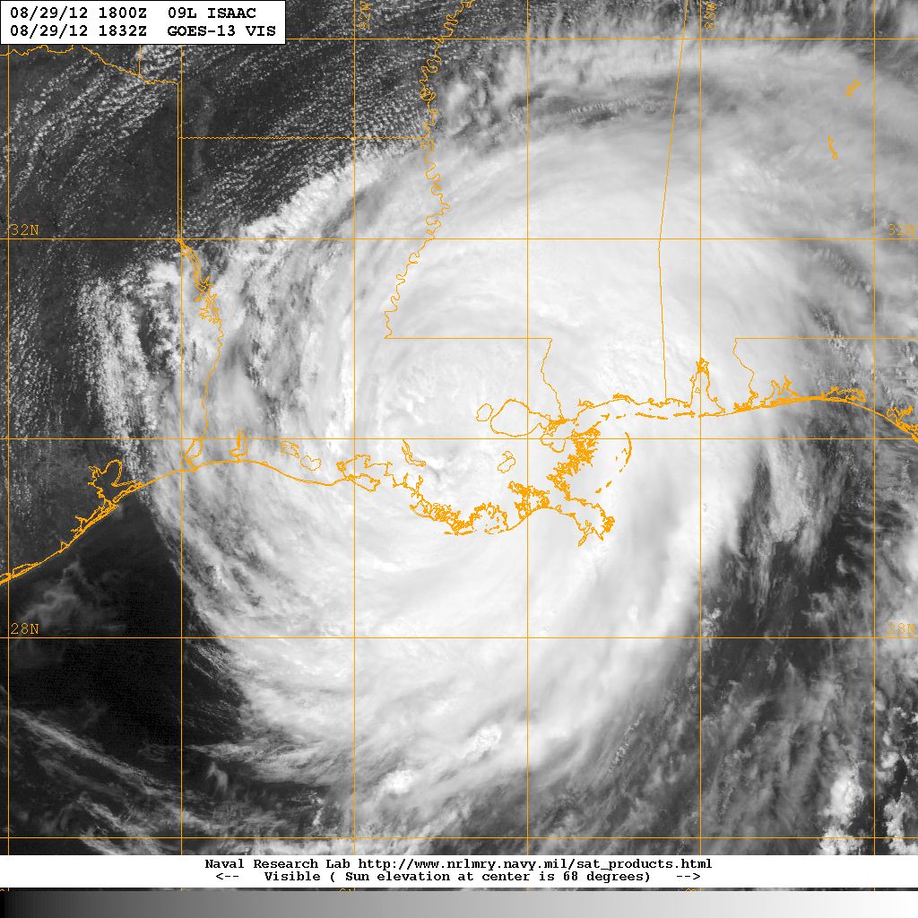
It's been a long day in most parts of coastal Mississippi and Louisiana. The misery may spread further inland as Tropical Depression Isaac moves NNW at 9 mph. Despite Isaac's weakened condition his watery legacy remains and severe storms are still possible in his spinning bands.

Slidell LA has been dealing with rapidly rising water all day. They are still going through Plaquemines Parish looking for people trapped in their homes. There is a possibility of a dam failure far to the north of where Isaac made landfall.


Over a million people are currently without power. Damage assessments are going on as I type this and it's meaningless to say a lot of trees are down. Every town has lost trees, much in the way that Raleigh and Charlotte far inland suffered tree damage from Fran.People here in Raleigh keep talking on their memories of Fran and how unprepared they were for the amount of damage they had so far inland. It's hard to fathom the threat to your life and property when you have the illusion of safety living far from the coastline.

Notice the little red indicator at the top of the image above. Notice how far away it is from where the coastline is, however that is where the dam is that may break where the town was evacuated.

A cute area where there will be no school for a while and residents will wonder what happened and why they did not think this could happen to them.


http://www.tangischools.org/site/default.aspx?PageID=1

http://www.wwltv.com/news/local/Tangipahoa-Parish-orders-immediate-evacuation-after-potential-levee-breach-167994886.html

This is the real story, not the sexy pictures and dramatic footage of Al Roker and Jim Cantore hanging onto each other in a deserted street that by their own words was a "wind tunnel" vs the street a few blocks away where Stephanie Abrams had barely any strong winds. It's not the weather guy by the water front where everyone was evacuated except for the film crews... no...the real story is in the small bayou towns and parishes and small cities far to the NE in Mississippi who had up to 20 inches of rain.


Isaac is still spinning, pumping moisture up into the Mississippi River Valley.

This is the problem with every storm in that people in one area expect the last storm they felt. Everyone feeds into this by reminding everyone of the last storm... in this case Katrina. One thing you can always bet on is that the problems will be different, even if the track is the same.

Highway 90 is still out in some parts along the coast and should be shut down until Friday. Anyone ever want to take a nice drive, it's one of the nicest water front drives in the country.. except when a land falling hurricane hits nearby.

Tornado damage ..inland flooding... dam failures.... these are the intangibles of a hurricane.

As i said before... this was NOT Katrina, it was a different storm. Yet the hype on New Orleans and Katrina and the anniversary of Katrina eclipsed the REAL FEARS that should have been highlighted.

Isaac was for most of it's life time a STRONG, LARGE, WET, TROPICAL STORM and what they do is FLOOD areas... plain and simple. Allison comes to mind... so many come to mind.

This is the real story, the real drama:

"TANGIPAHOA PARISH, La. – Residents living along the Tangipahoa River were told to quickly evacuate after a potential dam break at Lake Tangipahoa, a breach that could release a torrent of water south into Louisiana.
Shorlty before 2 p.m., an immediate evacuation of Kentwood was called following a flyover of the area by Gov. Bobby Jindal and Tangipahoa Parish President Gordon Burgess. 
McComb, Miss., mayor Whitney Rawlings said there was a 50 percent chance the dam would fail. He said it was currently holding, but the concern is that it would eventually give.
“What they’re doing now is saying, ‘OK, this thing might go. People need to be moving now in case it does go.’ And lord only knows if this thing holds or not,” Rawlings said.
Around 10:10 a.m., a mandatory evacuation was called for areas along the Tangipahoa River from Kentwood through Robert, an area that would affect between 50,000 and 60,000 people. Residents within a mile of the river were asked to evacuate.
Evacuation routes to get out LA-16, LA-40 or LA 442 to Hwy. 51.
Gov. Bobby Jindal has agreed to send over busses to help with the evacuation, Burgess said.
With the Tangipahoa River already swollen from heavy rains from Hurricane Isaac people in towns below the dam, like Robert, La., frantically worked to evacuate, packing up belongings, loading up their cars and trucks with pets and possessions to get out in case the dam fails."

I truly wish that people would be prepared for these possibilities by the News rather than all the focus on which waterfront spot gets the honor of being the spot where the storm made "landfall" and until that is dealt with people will not be properly prepared for these storms.

Everyone wants to be seen on Canal Street, but no one goes to the little towns and parishes with the simple folk and talks to them before the storm. Only the glamorous shots with Al Roker plugging the food at the Ritz vs talking to the people in the Bayou or the small suburbs north of Biloxi, way north of Biloxi.

Anyway, that's the story for today.

Over a million without power. It's going to be a long Labor Day Weekend for people to find out if all of their loved ones are alive and if their homes survived.

Hurricane Kirk is strengthening in the middle of the Ocean going out to sea...

Tropical Storm Leslie has formed south of Kirk moving westward for now, expected to also recurve,, however there are models that indicate that may change or she may get much further west.

It's a busy Atlantic Hurricane Season, El Nino has been a no-show so far.

Leslie is looking pretty good for a "new" Tropical Storm.


Really have to hand it to the people who manage websites on hurricanes like Mike at www.spaghettimodels.com or www.flhurricane.com as they work nonstop trying to stay on top of 2 or 3 different systems, updating often and it's a hard job and they do it well!


From SpaghettiModels... 

So much easier to use than sites with a dozen drop down menus and long directions.

As much as I love TWC... I can never use their site easily.
You need to go to AAA to get a map to learn where things are..
When I am in a rush I want fast information all in one spot.. 

So, that is the story for me.

Took a few hours off today, went to Trader Joe's in Cary to shop for food for Shabbos and ran in to Hurricane Grill and Wings to get a drink and relax. Every one's been teasing me that I need to take a break and go get a drink... was $2 Margaritas today :) so I had a drink! Always a cute place to sit, hang out and talk to friends. Not a lot of Vegetarian Options but..... with 2 dollar drink specials I can't complain. The manager William is nice, the owner Cindy is nice.. spoke to them a bit on their North Carolina Hurricane memories. 

http://hurricanewings.com/cary/    <---- cute, though they did have football on TV not TWC... but guessing I'm one of the only ones around who lives and dies by TWC ;)

And, what did I learn? Am beginning to believe the better part about having a Hurricane Party when a hurricane comes is that you sleep through most of the storm and only wake up for the aftermath. I had several people in OBX tell me they always get drunk before the storm, have had people in Raleigh tell me that. Being a girl from South Beach I figured it was just an excuse to party, now I'm thinking it's a way to avoid dealing with the reality of what you may find in the morning.

Lastly, I was in Manteo for the one year anniversary of Hurricane Irene. I spoke to someone who insists the sound was so dry you could walk across it. In fact, he said he drove from Currituck to Kill Devil Hills in his pick up truck after Irene. And, he emphasized that no old timer anywhere ever remembers that happening ever before. Usually the storms come in from the East...   That is similar to Miami which usually gets storms from the East or the SW, but rarely the direct hit from the South that might push the water up the Miami River and UP Biscayne Bay in a similar way. And, brings home the point that the people in Plaquemines Parish who didn't evacuate did so partially because the flooding there had never happened to that scale ever that they can remember. Old timers said they never remember that much flooding, ever.............

When it comes to Hurricanes NEVER and EVER and ALWAYS are words that should never be used..

Jacksonville NEVER gets a strong hurricane.

Tampa NEVER gets hit.

The storms ALWAYS turn just off shore.

Etc... etc... etc...

Each storm is different and the next storm will not be like Isaac it will be like whatever that storm is named.

Miami's next storm will not be like Andrew or Wilma. Andrew did not turn like David did...

Etc...etc...etc.

Something to think on and remember.

Hoping the dam does not fail, and hoping that cities up the Mississippi river do not have similar problems.

Take care, stay tuned and stay safe. The good news going into Labor Day Weekend is that there are no more storms on the horizon that should affect your weekend. Go to the beach, spread some money around at the little stores and shops and help the economy, make some memories and enjoy what is left of the summer.

Besos Bobbi

Ps... we did the beach last week after the big Reunion Road Trip...   and finally, at long last fell in love with the Outer Banks. Hated it that last time I was there (sorry I did, honest) but this trip was wonderful. It's not Miami Beach, it's different... but it's nice. Not a lot of Palm Trees but lots of but a lot of sandpipers and I so love sandpipers ;)

I'll be back later with more information ...

IMAG0528.jpg


IMAG0508.jpg


IMAG0474.jpg


Tropical storm leslie forms... Officially

Taking a little break.... Be back later with details...

As soon as I finish my margarita.

storm formed while I'm at hurricane grill and wings...is that an omen or what?

The way the dolphins season is going it will defy the models and hit Davie, Florida.

Besos Bobbi

ps...how does a plane back into another plane on the runway??


Expect an Upgrade to TD or TS LESLIE STATUS in ATLANTIC

Just a quick update as this is a go for lift off.... Red Circle at 100% Chance of being upgraded by the NHC


I'll be back with more info on Isaac who is now over Alexandria Louisianan (beautiful country) and the ongoing rescue attempts in other areas...damage reports as they pick through the debris in Mississippi from yesterday's storm related tornadoes.

Also.... note that combined with the Florida power outages over 1 Million People have lost power due to Hurricane Isaac.

At least one woman lost her life... expect that toll to climb sadly.

More later

Besos Bobbi

Ps... stay alert and stay inside if you are in an area where the weather is bad...you CAN wait a few more hours for it to clear before cleaning up and looking around!

Wednesday, August 29, 2012

Isaac Slowing Down, Kirk Weak & Tropical Storm Leslie Close to Getting a Name


Tropical Storm Isaac has now slowed down to only 5 MPH forward speed. That is basically a crawl vs a drift. I'm not sure at what point the NHC pronounces something "stationary" but we are about as close as it gets officially.

Looks the same now as it did before dinner.  A slight bend to the NE which is strange, unless it's about to wobble NE. Wobbling is not movement, it is basically a sort of cyclonic looping.

The track seems to be bending more to the East at the end point, moving towards Virginia after going up the Mississippi River. That is a sign a trough will pick him up, which is good.


Tropical Storm Kirk looks weak, very weak and small in the middle of the Atlantic.


Kirk is small, weak and staying out at sea.


This is the system that is soon going to become our next named Tropical Storm. Leslie, the next name on the list will be a bigger storm than Kirk, more Isaac like in size.


Look at that blow up in convection in what seems to be the middle of the system.  More important, the NRL added a "track" to their site, a good tip off they are waiting for an eventual upgrade.


Models are a little loopy right now and the situation down the road will depend on how fast Isaac moves out and frontal systems coming down from Canada and if the Atlantic High builds back in strong and lastly...how fast Leslie pulls it together. Again, weaker storms get further west.


http://www.ssd.noaa.gov/goes/east/catl/flash-avn.html

NOW... back to Isaac, our storm of the hour and probably the year.

The water vapor loop shows us that he is trying desperately to bust through the ridge. I'd say he's an over achiever here, but I suppose because of his size it is possible.


The above image is from 12 hours ago, earlier this morning.

The image below is a current image. Notice the bulge that has formed in the middle of the ridge as Isaac bumps his head against it over and over as he spins almost stationary trying to find his way north.


Sort of impressive if you ask me. Still, Isaac is trapped and until he can break through he will sit and move at nearly 5 mph or in reality not move at all, just bobble around Louisiana like a bad house guest who will not pack up and go home.

On another loop it looks as if the ridge is bending and reaching down under Isaac to lift him up and out. Possibly why he has that NE orientation suddenly.


Odd angle, but look at how much rain is out ahead of Isaac caught up in his signature:


The damage totals are high and still climbing and most of the damage has not been seen yet. Images and stores are just coming out, person by person, tragedy by tragedy, near miss by near miss. 

Watch Isaac spin... stay inside, even if they have lessened his intensity... his rain remains the same.


My biggest concern tonight is that people stay INSIDE and HUNKER DOWN and not get Cabin Fever and feel the need to "go out and find food" which one they should have already had in the house and two...there is no food out there and stores are closed and there... the water is deep, the weather is strong and driving around is not for the average person... stay home, stay safe and wait it out.

Let the Emergency Responders be out.. let the chasers be out and the news crews be out.. stay home if you live anywhere from Gulfport to Baton Rouge... stay home stay safe.

I'll be back later with more details. I just wanted to do an update on where we hold with the 3 Stooges tonight... Isaac, Kirk and the soon to be named Leslie.

An interesting link from www.spaghettimodels.com shows how these last storms took a bite out of SAL: 


A large chunk took off for what seems Florida and Carolina. Soon to be Leslie seems to be not as affected as the last few storms. 

Also he has several good water vapor loops, though I love Unisys for my own reasons, there are better sites and more options on his page. Find the loop you love, but check them all out.

Be back later...Besos Bobbi


Tropical Storms Isaac & Kirk (and Possible Tropical Storm Leslie forming)

Hurricane Isaac has been downgraded to a Tropical Storm. This means NOTHING as this is about the rain and the flooding, not the wind. The damage will be the same if he is a Tropical Storm or a minimal Hurricane.

Means about as much as the night I sat staring at the TV and they downgraded Andrew by 5 mph back down to Category 4 status. WOW did I feel better..............NOT.

Isaac's story is rain, storm surge, inland flooding and levee failures... NOT wind.

So, don't you pay any attention to that and don't go out and celebrate. We are a long way from this being over.

Looks the same to me.. big, wet and slow moving.


Actually he looks very well formed.
Round. 
Wet.

A reminder Tropical Storm Kirk is also out there spinning, though he is currently forecast to stay out at sea.


Here's a larger view for perspective and note... the area to the West will most likely be Tropical Storm Leslie in the near future.


Ummmm there is a another system behind the current Invest that is red at a 60% chance of forming...


Busy day in the tropics....

Besos Bobbi