Hurricane Harbor

A writer and a tropical muse. A funky Lubavitcher who enjoys watching the weather, hurricanes, listening to music while enjoying life with a sense of humor and trying to make sense of it all!

Sunday, October 30, 2011

Winter Whispers Hello Up North, Rain and Severe Weather In Miami

Still raining in South Florida.

http://www.intellicast.com/National/Radar/Metro.aspx?region=mia

You know it's funny. When you look at the satellite image we seem to be on the edge of the rain. When you look at the radar, it l oops like it will never go away.

The power was sketchy on Saturday, it flickered a lot and for some neighbors down the block it was off. FPL trucks were in the area all day doing work. But, in general it was a nice rainy day. I sat outside on the covered, screened patio with a cup of Nespresso and a few cookies watching the rain fall. Listening to it. Loud, steady, heavy drops in a never ending flood of rain. Nothing more, though the skies for a while were purple and there were a lot of funky, cloud debris sort of fake funnel clouds. Not really funnel clouds but some definite circulation going on just above the surface.

In New York, where some of my kids live....they got snow. Really snow. A lot more snow than they figured on. My youngest daughter saw snow flakes falling for the first time. Heaviest snow fall in some parts in history, or at least since they've been keeping track. The snowfall during the Civil War is not recorded with the records. New England got snow...sorry about that. Winters here or rather there.

In Miami the Fins lost again . . . .

There was a Tornado Warning down in Kendall, but nothing here. This is what our local weather warnings look like:

BULLETIN - EAS ACTIVATION REQUESTED
TORNADO WARNING
NATIONAL WEATHER SERVICE MIAMI FL
855 PM EDT SUN OCT 30 2011

THE NATIONAL WEATHER SERVICE IN MIAMI HAS ISSUED A

* TORNADO WARNING FOR...
EAST CENTRAL MIAMI-DADE COUNTY IN SOUTHEAST FLORIDA...
THIS INCLUDES THE CITIES OF...SOUTH MIAMI...KENDALL...

* UNTIL 945 PM EDT

* AT 853 PM EDT...NATIONAL WEATHER SERVICE DOPPLER RADAR INDICATED A
SEVERE THUNDERSTORM CAPABLE OF PRODUCING A TORNADO NEAR PERRINE...
MOVING NORTH AT 5 MPH.

THIS STORM IS ALSO CAPABLE OF PRODUCING DESTRUCTIVE WINDS IN EXCESS
OF 70 MPH.

* THE TORNADO WILL BE NEAR...
PERRINE...
PINECREST...
AND SURROUNDING COMMUNITIES.

PRECAUTIONARY/PREPAREDNESS ACTIONS...

Maybe tomorrow this frontal boundary will clear out. It definitely did NOT make it down to Cuba.

Nothing else is new, everything is status quo. No news is good news?

It was a blustery, beautiful day as we walked around getting some fresh air and dodging the raindrops.

Down by the Yucatan there is some rain but I am not going to even look at it tonight. The NHC says "nothing doing" and I'll go with that.

So, button up that overcoat if you live in Upstate New York or New England because winter has whispered hello this weekend.

Sweet Tropical Dreams...and remember tomorrow is a brand new day ;)

Bobbi

http://www.youtube.com/watch?v=v-pEOUbr9yo

Friday, October 28, 2011

NHC Tracking Vanishing Center as Rina's Rains Track Towards South Florida


This feels so Deja Vu of Irene 1999 that no matter how many times I close my eyes and open them again I think to myself I've seen this scenario before.

Look at this loop:

http://www.ssd.noaa.gov/goes/flt/t1/flash-ft.html

It shows a MTE (Mass Tropical Ejection) headed NE from the tip of the Yucatan towards South Florida. Exactly the way the models showed this would play out about 7 to 10 days ago.

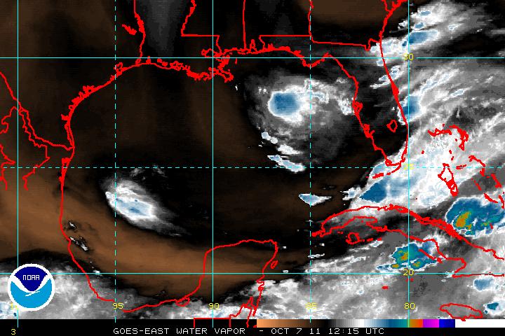
Look at the wider view:

http://www.ssd.noaa.gov/goes/east/carb/flash-ft.html


As seen in this picture the circulation center is barely visible over the tip of the Yucatan, however the rain and weather associated with Tropical Storm Rina is moving as an entity towards South Florida caught up in the Southwesterly flow out ahead of a frontal boundary to the North of Florida. There are still Tropical Storm force winds caught up currently in this area and it will most likely affect the South Florida area with some severe weather in the next few days. Stay tuned to your favorite local weather forecasters and pay attention to any NWS bulletins they may issue and stay closely informed on changing weather in your area. The "low level center" that the NHC was tracking may be dying out.... but the weather is not dying out, not yet.


This won't be Irene from 1999. But it could have been and whatever it will be my hope is you are watching the local weather and not ignoring it because you hear that Rina died a quiet death down on the tip of the Yucatan and then you get heavy flooding, your car gets stuck in a parking lot in Aventura and strong winds blow your patio furniture around in an unconfirmed tornado.

Watch your local weather:


It shows Rina or the remnants of Rina surging NNE to NE towards South Florida caught up in the strong SW flow that is riding out ahead of the weak cold front that is going to bring out temperatures back to a slightly less balmy 72 degrees at night vs 75 at night.

Google Weather for 33162 my home zip code:

81°F | °C Fri Sat Sun Mon
84° 73° 79° 72° 79° 74° 80° 72°
Partly Cloudy
Wind: SE at 5 mph
Humidity: 84%

Do you see a cold front moving through South Florida?
No. That's one of those "our temperatures are a bit milder from a weak frontal passage"

For 33162: http://forecast.weather.gov/MapClick.php?CityName=Miami&state=FL&site=MFL&lat=25.77&lon=-80.2

To change that to your local area, put your zip code into the top and get your local forecast.

Hazardous Weather Outlook should be clicked on as well.

For instance mine says this:

"FLOODING: THERE WILL BE AN INCREASING THREAT OF LOCALLY HEAVY
RAINFALL LATE TONIGHT ACROSS THE REGION WHICH MAY LEAD TO MINOR URBAN
STREET FLOODING."

Yes, some people do pay attention to their local forecasts and the NWS. Unfortunately, not enough do as they check in to see what the NHC said in their advisory and then they go back to their favorite cable channel or watch the last 3 episodes they missed of their favorite show. We were trained to check the latest advisory and when they say it is dying out and being downgraded we go "oh, guess that's that" but that is not always that's that. There is often more to the story.

Do you see a vortex down near the tip of the Yucatan going southbound? No. I do see weather from 97 trying to pull together but having a difficult time and a high aloft that could possibly help 97 come together as a named system but I don't see Rina's lower or mid level vortex. I'm sure it's down there somewhere on the visible, a wisp of a swirl that the NHC is going to keep tracking as they hand off the mass that is/was Rina to the NWS to forecast.

Official Track Forecast for Rina:


This is silly guys. I'm sorry. I call it as I see it to quote an old weather friend.

South Florida is going to get deluged with the remnants of what will be down graded but what is the remnants of Rina and someone is going to get very wet and somewhere it's gonna get very windy. Where exactly I don't know, because weak systems like this spread out over a larger area than if she was a neat Category 1 storm with a clearly defined center.

And, since my purpose here is to talk to my friends in the South Florida area I'm saying this:

Just because Rina is officially downgraded (or isn't) we will get a very rainy weekend. We as in everywhere from Tampa/Orlando south down to the Keys and including Naples, Miami, Ft Lauderdale/Hollywood and West Palm Beach. At this rate as the front dips a bit south areas to the north of Palm Beach along the Daytona coast may get a lot of weather.

Not a fun beach day unless you like to go to the beach and take pics of the beach.

How fast it will take to go through..not sure.

Let me say I do understand why the NHC is doing what it is doing and saying what it is saying. It is how they work and they work by many rules that they have to stand by. I don't. I tell it the way I see it and I am either right or wrong. I do not have to answer to a lot of higher ups. Either you keep reading my blog or you don't. I'm giving good information you need in an informative and often entertaining way or I am not.

Line from NHC at 8AM:
..RINA CONTINUES TO WEAKEN OVER THE NORTHEASTERN YUCATAN PENINSULA...

http://www.nhc.noaa.gov/text/refresh/MIATCDAT3+shtml/280836.shtml

"THE RAGGED APPEARANCE IN RADAR IMAGERY SUGGESTS THAT THE SMALL CIRCULATION OF
RINA MAY ALREADY BE SUCCUMBING TO THE INCREASING SOUTHERLY VERTICAL
WIND SHEAR. SOME MID-LEVEL ROTATION HAS BECOME APPARENT JUST
NORTHEAST OF THE TIP OF YUCATAN...WHEREAS SURFACE OBS INDICATE THE
SURFACE CENTER IS STILL OVER LAND. WITH THE VERTICAL CIRCULATIONS
FORECAST TO COMPLETELY DECOUPLE DURING THE NEXT 12 HOURS OR SO...
THE LOW-LEVEL CENTER IS EXPECTED TO GRADUALLY TURN SLOWLY EASTWARD
AND THEN TURN SOUTHWARD BACK OVER THE NORTHWESTERN CARIBBEAN SEA BY
24 HOURS. THE OFFICIAL FORECAST TRACK IS SIMILAR TO THE PREVIOUS
ADVISORY AND IS WELL TO THE RIGHT OF THE CONSENSUS MODELS...TVCN
AND TVCA.

Line from BobbiStorm:

Stay tuned at this point to the NWS because they will be the ones that will be tracking what was or is Rina not the NHC who will pronounce her dead in the water south of the Yucatan shortly... unless something big time changes over there and I doubt it will.

They were tracking the organized center of a system, not a "weather mass" and as we learned in 1999 a Weather Mass can be a real Weather Mess if you are not prepared for it and you don't switch over to the NWS for news when the NHC decides your area is not getting hit by a significant named swirl. We may not be getting a Tropical Storm but we may be getting a very tropical mess.

Point: The hype may be gone, but the weather is still there. Hoping for a sunny day on Saturday and balmy weather but if not don't be taken by surprise.

And, according to the NHC keep watching the other two areas for possible development.

Up north...enjoy the snow.

Down south...enjoy the sunshine and the occasional rain. And, be glad she "fell apart" and the rain you feel on your face tomorrow is not from a Hurricane!

Besos Bobbi


Moral of the story....if you live in South Florida learn Spanish ;) and listen to that little voice down in your gut even if it makes no sense sometimes.

http://www.youtube.com/watch?v=N41gOPiMNVs&feature=fvwrel

Pps...sorry for any mistakes or typos..... not on my own computer but on a really nice big Apple :)

Enjoy as I stroll down memory lane as I listen youtube as my daughter-in-law who I love very, very much makes a smoothie instead of going into labor ;)

http://www.youtube.com/watch?v=KKC3W0awjm0 <---award winner

Ever notice the same actor is in this movie as in Twister :)

http://www.youtube.com/watch?v=y4bxPMPdcBU

http://www.youtube.com/watch?v=H4eSrpb4SDU (really in the mood for this movie)

http://www.youtube.com/watch?v=cYpz3abAk98&feature=related :)

Thursday, October 27, 2011

Tropical Storm Rita Weakening Slowly

Tropical Storm Rita is weakening slowly over the tip of the Yucatan as she moves North at 7 mph. This movement is forecast to stop and change directions and go south. Where she was once forecast to go left and then right, now she is forecast to go south again. Eventually she is expected to die out and diminish in intensity over the Caribbean Basin.

Oddly it is pulsing up again and looks better now than it did a few hours ago. I suppose that's an illusion or there is some explanation for it.

http://www.intellicast.com/Storm/Hurricane/CaribbeanSatellite.aspx?animate=true

I'm not sure why ... other than November storms often do this dance... she still has an ample moisture supply to the SW of her and I'd think she's gonna rain over areas that don't need rain a little bit longer.

The front is moving very slowly and seems slower every day. When I say slow I mean the dipping south part, not the part that moves west to east. The NE should get really wintry weather.

Here in South Florida we are not expecting any significantly cooler weather for the next several days. Again, as I said the other day I did not see the front zooming through South Florida on Friday...and it isn't. Temps in the Mid 80s during the day, Mid 70s at night. Nice.

Of course in the house here the AC is on really strong and it's cold, cold, cold. Got a pregnant woman here and she likes it cold. Hey I know how she feels... I was pregnant a few times and I kept it set for cold and colder too!!

A few areas to watch but nothing that is going to go pop in the middle of the night so hang back, relax and watch Rina fade slowly away. I guess.

Sweet Tropical Dreams

Bobbi

Hurricane Rina Hanging In.... Forecast to Fall Apart


Despite being forecasted to fall apart, she has an odd way of pulsing up over and over again. The green on Funktop is back in the center and making me wonder when exactly and why she would be falling apart. Also wondering why she pulses up and down, she's an interesting storm to watch.

http://www.ssd.noaa.gov/goes/flt/t1/flash-vis.html

The front is moving but it seems to be more flat than digging and also hangs back and moves east again. Eventually it is forecast to dip down.


Meanwhile, Rina is still down there doing her thing...totally stubborn and tougher than she looks I guess and not budging until she is ready to budge.

Miami is out of the cone. Key West is almost out of danger. At this rate I'm wondering is she will cause Cuba problems or sit down there and then loop back up with the next front. Who knows? The NHC has low confidence still in their long term forecast.

More so a little curious on the increased convection in the wave known as 97 to the SW of her. Now, if he developed the way some models earlier in the week forecasted he would...now that would be something interesting.... time will tell.

Keep watching.... and enjoy the weather wherever you are...

Besos Bobbi

Wednesday, October 26, 2011

..RINA HANGING IN THERE WITH 85 MPH WINDS...COULD BE A LITTLE BIT STRONGER...


..RINA HANGING IN THERE WITH 85 MPH WINDS...COULD BE A LITTLE BIT STRONGER...

The above is the official line out of the NHC.

Rina is now forecast to take the lower track and to die out slowly along the north coast of Cuba... somewhere near the cold front seems to now want to die out. Seems both are not long for this world.

Only one model still takes her to Florida. The other models show her diving south down into the Carib or lingering off the coast of Cuba.

And, yet.... they added the big "BUT" with the"could be a little bit stronger" and the encouraging "hanging in there" like they expected her to be down to 75 or 80 mph but alas she is still 85mph. Darn they hit her with all they could, tried mind control and showed her pictures of haciendas near Havana but no she is hanging in there...

Will see. She looks pretty good for a weakening girl. Still some nicely placed greens tonight on the Funktop.


They also S L O W E D down the time frame again and have her barely moving. My problem is that I can barely see the frontal boundary that is supposed to be here tomorrow....


All I see is a nice round storm sitting down there and not much of a frontal boundary anywhere. In theory, aside from upwelling problems the reason she weakens is that the frontal boundary doesn't pick her up and shoot her off to the NE.

I see Rina. I don't see the mean, strong cold front... just yet.

Sweet Tropical Dreams . . .

Bobbi

Miami Still in the Cone as Hurricane Rina Moves WNW @5 with 110 MPH


Tuesday Morning and Rina is still a Category 2 storm sitting neatly down in the Caribbean in a little pocket of warm water on the ledge of land North of Honduras and just east of Belize moving wnw at 5 mph. Slow, steady movement towards the tip of the Yucatan. She is just sort of swirling down there, dancing her way closer and closer towards those Mexican resorts. She doesn't seem to be in a hurry. Her slow progress is probably beginning to cause some upwelling which lowers the temperature of the water from VERY HOT to HOT to very warm. It could be there reason she has yet to become a Category 3 storm. She still has time though at the moment she seems bound to maintain her status vs a bout of rapid intensification.

Tell you one thing. The NHC took a long, long time before putting out their 11 AM Discussion. I waited on it before posting and rarely do they rarely wait until exactly 11AM to put it out. Basically, it is an update of their 5AM with some good discussion on why she might be weakening and leaving the door open to say that she might not. It's a hard call for anyone to really say just yet and a lot of people keep tuning in to see what's changed and the reality is not much has changed. She looks a bit ragged on the imagery according to one person, another person thinks she looks better on imagery. She has nudged a bit to the north and that was the main change...from due west to wow. The Cone looks the same, an extrapolation really of their 5am graphics package. Good discussion from Beven who does his job well and is enjoyable to read.

"The dynamical models forecast the ridges to the north and west to weaken during
the next 48-72 hours as a trough in the westerlies and associated
cold front move into the Gulf of Mexico. This evolution should
cause Rina to gradually turn northward near the East Coast of the
Yucatan Peninsula. The track guidance is in good agreement on this
part of the forecast...and the new forecast track is similar to the
old one."

I will say I have a problem with the timing. They have slowed down the forward progress of this storm a lot. And, in my mind IF she was catching the front she would move faster than the NHC has her moving. IF she doesn't catch the front... I don't see her getting that far into the Florida Straits unless the front bombs out.... so that is my real question here. Why get her that far north and then move what seems to be due East when the discussion has been that the front would move down into Cuba...in which case she would not be going due East at 7am on Monday. I am sure that it makes sense to people who know a lot more than I do and they are again averaging out models and extrapolating and they have to answer to a much larger audience than I have here but that is my problem with the current cone.


I'm still in the Cone Zone in the northern part of the bubble.


Actually, when you consider how many really excellent waves were unable to come together earlier in the season to even Category 1 status what she is doing down there is pretty amazing.

Official wording shows that the NHC most likely believes she will be more like Floyd from 87 and NOT like the Wilma that we remember vividly in South Florida. Note how similar the two forecasts are that call for South Florida to have stormy weather but not hurricane weather.

Text from the NHC Discussion this morning:

AND THE OFFICIAL FORECAST...SHOW
SIGNIFICANT WEAKENING IN THAT TIME FRAME. THEREFORE THE OFFICIAL
TRACK FORECAST...LIKE THE PREVIOUS ONE...SHOWS ONLY A SLOW EASTWARD
MOTION NEAR THE END OF THE PERIOD. THIS IS REASONABLY CLOSE TO THE
LATEST GFS TRACK. IT IS WORTH REPEATING THAT THERE IS GREAT
UNCERTAINTY AS TO WHERE RINA WILL BE LOCATED BY THE WEEKEND.

Text from Miami Marine Forecast:

FRONT THAT MOVES OFF THE TEXAS COAST LATE THU AFTERNOON OR
EARLY EVENING. THE FRONT WILL QUICKLY REACH FROM THE FLORIDA
BIG BEND TO THE E BAY OF CAMPECHE FRI NIGHT THEN BEGIN TO
INTERACT WITH HURRICANE RINA CURRENTLY IN THE NW CARIBBEAN
SEA. RINA IS FORECAST TO MOVE TO 20.5N 87.0W THU
AFTERNOON...THEN BEGIN TO WEAKEN AND TURN NE TO NEAR 21.8N
86.6W LATE THU NIGHT...23.5N84.5W LATE FRI NIGHT...THEN TURN E
AND WEAKEN TO A TROPICAL STORM NEAR 23.5N 83.0W LATE SAT...AND
23.5N82W LATE SUN.

Models are similar but still split on whether she is able to withstand the Cold Front that will move down into the Gulf creating tremendous shear and which may blow her apart or whether she will just bobble around down there and stay on the maps for weeks down the road. Could she really do a small little loop, fall apart and then reform strong again down in the Caribbean vs zooming NE towards and across Florida? Waiting to see this drama play out.

Sort of like life. Somethings in life you just can't rush. You have to wait and see how they turn out. And, while you are waiting may I suggest listening to some good music, sipping some good espresso and enjoying the feel of balmy, breezes off of Biscayne Bay. Now, if you are reading this from Houston or Hungary then find a spot where you love to delight and enjoy some delicacy and check back later.

Models at 11 pm last night are not very different from models at 5 am. Still an either or scenario.

11PM


5AM


Note the NHC seems hard pressed to decide which has a better handle on Rina...the GFDL or the HWRF. Note none of the models have her dying out where the NHC shows her coming to a halt. The HWRF shows her diving south as a reaction to the high from the cold front which doesn't grab her. That would be a temporary movement and if she maintained herself she could regroup later as that cold high air will only be a temporary thing in the land down under. The GFDL has her predictably getting caught up in the cold front and zooming across South Florida out into the Atlantic. Now...which is more logical and more in step with climo for an October storm? Another question...is this an October storm or a November storm in October. IF she is a November storm

My brother wants to know how we are supposed to believe the forecast when they have been wrong with this storm already a few times. A lot of "IFS" in the forecast. IF it hits the mountains in Cuba... IF it doesn't catch the front... IF it stays in the Passage... a lot of IFS. We are basically waiting to see how much shear really builds up and how it affects her. If we are already into November from a Climo perspective she will sit down there and not catch the front and do weird kinky things. IF she is a true October system she will grab the front the way the GFDL shows and we will see a US landfall.

October Storms:


Snow in Denver:

http://www.youtube.com/watch?v=VVwwp3sXAro&feature=youtu.be

As for me... I'm going in the shower and then going to go about my day peeking back and forth to see just what if anything has changed. Been fun learning how to use an Apple from one of the best teachers around with hands on experience while I sit here waiting and watching and enjoying the Cafe Con Leche and the tropical breezes in the backyard.

I will say one thing. We took a walk last night not the Boardwalk in Hollywood and the breeze was really strong. Almost chilly and it swung around out of the north from an onshore wind for a bit and I thought it reflected well the battle going on in the Modelsphere as we have definitely gone zonal and cold fronts are sprinkling snow early this winter. Easy to say that the cold front might not grab her but if she stays down there....well things spin up on the edge of old frontal boundaries all the time which would lead me to believe she would only be playing possum down there waiting to spin up again should she not take the easy road out of the tropics. As always, time will tell...


Will end this with the thought that Rina is a storm that sits in a small pocket of tropical air above warm water and is able to continue maintaining her strength despite everything else going on around her. To the north there is dry air, there is shear nearby and yet she keeps on spinning at Category 2 strength. She might make it to Cat 3, she might not. She will eventually slow down and diminish in intensity. But..... unlike other weaker waves that could not become a hurricane this season, she is doing her thing even if it is in a small corner of the warm Caribbean. Don't count her out. Will she be Wilma or go flat like Floyd? I don't know for sure though the NHC seems to think she will fall apart past like Floyd once the big bad cold front from the north moves her way.

Leaving you with a video of my daughter Dina hooping in her small, but very cute kitchen. I get nervous when she does it in my living room... I suppose I should not worry because if she can hoop in her cute, little kitchen which is about the size of Holly Golightly's kitchen I suppose she can hoop anywhere .... and so can Rina for a while.

http://www.youtube.com/watch?v=WIja0juvlnI&feature=colike

Besos Bobbi ;)

Ps...note that is my term Modelsphere. I want credit for it!

Tuesday, October 25, 2011

Hurricane Rina.... Steady Solid Intensification


Hurricane Rina is currently looking beautiful with excellent outflow in all directions. She has been under minimal shear and yet her appearance doesn't show many ill effects from the shear.

Another interesting thing about Rina is she seems to be moving left of the program, she's missing her marks and they may have to adjust her once again at 11. Will see. At 8PM they said she was meandering. She is still meandering westward. Then again many of the models showed her moving west and then eastward.

"..RINA MEANDERING WESTWARD...EXPECTED TO BECOME A MAJOR HURRICANE TONIGHT..."

Look at the overall, bigger view of Rina with regard to the whole basin. Everything to the north of her blows off to the east. Where she goes over the next 48 hours will make a big difference where she goes in 90 hours. More so...where the front goes, how far it dips and how strong it is in relation to how strong Rina is after she does the Tango in Cancun. And, what if she hits south of Cancun and bounces off and bobbles around in the Caribbean longer and not taking her trip NE? Some models do have Rina doing a loop and staying down in the Carib until Lord only knows when. To complicate matters....the system to the ESE of Rina known as 97 has model support for intensification as Rina sort of falls apart. A really big "Hmnnnnnnnnn" which means got to see that one to believe it but hey it's October in the tropics...anything is possible. The water in that part of the Carib is by the way........REALLY HOT!

http://www.ssd.noaa.gov/goes/east/tatl/flash-wv.html

Would Rina really fall apart suddenly as some models show or intensify rapidly? She is about to tap into more moisture to her SE that should give her some more juice.

http://tropic.ssec.wisc.edu/real-time/mimic-tpw/natl/anim/latest72hrs.gif Juice Loop

As of 11pm there is still a lot of indecision and low confidence in what Rina will or won't do in the long term. Her present movement is to the west at 3 mph (no longer meandering, slowly moving west) and she is forecast to be a Category 3 storm at any time. There are two roads to travel. One road takes her NE towards Florida by riding up the frontal boundary. The other road keeps her looping around down in the Caribbean.

What do I think?

I think if this front is going to sweep through Cuba then it will pick her up. The discussion below is from the official discussion of the Caribbean Weather Outlook.

A COLD FRONT WILL EXTEND FROM WESTERN CUBA TO 12N84W SAT AND SUN. LOW PRES MAY FORM
AHEAD OF THE FRONT IN THE SW CARIBBEAN THU AND LINGER THROUGH
SUN.

Hard to say for sure. One thing I can say for now is she looks about as good as it gets and shows little sign of problems from the shear that was over her today. Amazingly, beautiful storm to watch spin on satellite imagery.

Time will tell... but what will tell soonest is the Gulfstream Jet that is taking samples of air around Rina and far away from Rina to which way the wind is really blowing in the atmospheric river that guides tropical systems. With the info from that wonderful forecasting tool the next model runs should clear up the long term picture.

For now...if you live in the South Florida area expect very gusty winds on Friday Night and Saturday Morning. Gusty as in very breezy, not quite sustained tropical storm force winds but a stormy period. Now, IF she comes further to the north we could have a real problem. Anyone south of Tampa should pay attention to this storm...that is the official line. Key West and Havana should get serious storm conditions.

More tomorrow when we get back good info from the Gulfstream Jet.

Sweet Tropical Dreams

Bobbi

Ps...Though the official track is to the south of my location I am very in the cone zone tonight...

More models call for a South Florida Hit from Hurricane Rina

More and more of the better models are making a case for some sort of landfall in the State of Florida from Rina, whereas last night the harder right turn out to sea was in play. I suppose this can change by tonight again, which is why we keep watching. I mean you have a Hurricane that is going Major very soon, Category 3 and it has Florida in it's sights on the 5th day. Not something to ignore.

Of course some of the models take Rina in a small circle, a little loop in the Yucatan Passage however the stronger the hurricane the more likely she will want to go poleward (NORTH) and that is what most of the models are picking up on today.

This model in particular makes me nervous, nervous in that it would impact a lot of people even as a weak storm. Of course we also had a weak Floyd back in 1987 that made the same trek up out of the Caribbean and didn't do much damage in the Miami area. Wilma and Floyd, both similar storms for this time of year.

http://moe.met.fsu.edu/cgi-bin/hwrftc2.cgi?time=2011102512-rina18l&field=Sea+Level+Pressure&hour=Animation

There is a reason that climo wins almost every time. It's the average of climate history over the long term, averaged out into the most likely pattern. Sometimes it loses, usually it wins. Time and time again it wins out.

Check out Wilma, a similar storm around the same time of year. A great analog storm.

http://en.wikipedia.org/wiki/Hurricane_Wilma

http://en.wikipedia.org/wiki/Hurricane_Floyd_(1987)

Tell me why this storm would not do exactly what Wilma did track wise or Floyd from 1987?

Another strange Fujiwawa sort of track from another model, extremely....highly unlikely but worth watching:

http://moe.met.fsu.edu/cgi-bin/hwrf-noaahfiptc2.cgi?time=2011102506-rina18l&field=
Sea+Level+Pressure&hour=Animation

Not likely as I don't see the newer storm killing off Rina, but it is fun to watch in a funky funny way.

Another problem with the newer models is the TIMING in that the models are speeding up and now taking Rina towards Florida faster and faster. This could be based on the fact that she is a stronger storm and more likely to be grabbed by the frontal boundary than a weak storm. However, the front does not seem to be diving so much...which is maybe why the NHC is actually giving wind probabilities for cities up the coast from Tampa to Jacksonville. Seems far out to me considering yesterday we were talking on her taking a hard right turn south of Cuba eastward.

Another problem is that the NHC seems not to feel that they have a good handle on her long term track (out past 3 days) and that's the part of the track that may or may not affect South Florida.

It is highly unlikely, though possible, that Rina will come to South Florida as anything more than a strong Tropical Storm or Category 1 Hurricane. That is not carved in stone mind you and we are talking Hurricanes not pumpkins.

So, keep watching..... stay tuned and enjoy the sunshine and the tropical breezes because it won't last forever.

BOTTOM LINE: What do I think will happen?

I think it's very likely that Rina will follow Floyd and Wilma's general path towards the State of Florida. She might enter Florida Bay after slicing across the Florida Keys, trek her way across the Everglades and exit south Florida somewhere from the Dade/Broward Line to Port St. Lucie depending on her angle of assault. Yesterday I thought maybe the Florida Straits, now I am thinking the front is not strong enough and she's stronger than she looks. Think Tropical Weather if you live in South Florida on either coasts and for sure the Florida Keys. Also, depending on the timing, tides...she could make a real wet mess flooding out whichever Key she decides to cross on her way towards Florida. If this new trend verifies.

Lastly, the NHC stayed conservative yesterday with their timing on Rina. I mentioned this. All the other models had her moving faster and the NHC played it conservative. Not sure how they will play it at 5pm for the big nightly news shows.

Either way enjoy this New Age Romanian Gypsy song ;)

http://www.youtube.com/watch?v=WP-fPKpFwig <-----NRG Band Rina Rina (great beat, love it)

Hurricane Rina Still Going Strong...watch and wait mode

Short post this morning just to say we are in a watch and wait mode. Rina is looking good, very ready to go to the next step however the recon did not find winds to support stronger than a Cat 2 storm. She is a small storm in that her core is small and her accompanied moisture is not large. However, if..a big IF....she merges with the frontal boundary that shape will change. IF she stays down in the Carib moving slow and not rushing to grab the front she might stay there a long time.

So, it's up to Rina. Take the high road or the low road.

The lady or the tiger sort of decision...

Besos Bobbi

Ps....if you live in South Florida do not keep your eyes off of her too long as you just never know for sure but otherwise have a beautiful sunny day!

Monday, October 24, 2011

Hurricane Rina, Grow Houses in Hollywood Florida and the Northern Lights

http://www.ssd.noaa.gov/goes/flt/t1/ft-l.jpg

If you will click on the above link you will see a Hurricane that is rapidly intensifying and on her way to Major Hurricane Status. I could go conservative and say she will be a Cat 2 but that would be lying. I think she will easily go Cat 3 if she continues this process throughout the night.

Beautiful, really.

I'd post a picture, but I'm not on my computer and just writing vs posting pics.

So, this sort of figures. Here I am in Miami, waiting for someone to give birth and watching a rapidly intensifying storm that many models bring this way over the weekend. Now, not only do I not know exactly when she is going to give birth ...while we are impatiently waiting, we also don't know whether or not we will or won't get Hurricane Rina. So typical of my life somehow.

What is wonderfully more typical is that a helicopter hovered over the house this afternoon while we were sitting out on the patio enjoying the beautiful, breezy weather. I made a joke about "what are they looking for a grow house or something??" and it seems I was right. Of course... back in South Florida with grow houses being busted and a swirling hurricane down in the Caribbean and most of the Florida Keys already in the Five Day Cone.

Facts on the storm that are worth keeping in mind... The water where it is right now is really, really hot. Possibly as hot as 85 degrees. She is moving very slowly and she is staying just south of some dry air and shear to her north. As I said the other day, she's like a star QB in a pocket with all the time to find his target. And, what city will be her target is somewhere in the wide, odd shaped cone out of the NHC. First she will go to the left and then she will go to the right. A funky sort of storm I suppose trying to figure out which way to go.

Sort of ironically funny in it's typical funky Florida way. Always some drama going on and yet after the helicopter flew away the sun began to set and paint a picture perfect sunset all coral and gold with touches of mauve mixed in.

Laughing so hard I can't stop coughing. It's perfect. Figures. What next?

In the world of the geologically bizarre there was an earthquake in the Cayman Islands. Moderately small, but big enough to get noticed. And, I'm thinking they are going to get a storm possibly in the same week as an earthquake. I suppose people who do astrocartography would be wondering what goes with the vibes....

Magnitude
4.1
Date-Time
Sunday, October 23, 2011 at 03:23:09 UTC
Saturday, October 22, 2011 at 10:23:09 PM at epicenter
Time of Earthquake in other Time Zones
Location
17.967°N, 81.442°W
Depth
10 km (6.2 miles)
Region
CAYMAN ISLANDS REGION
Distances
147 km (91 miles) S of GEORGE TOWN, Cayman Islands
271 km (168 miles) ENE of Swan Island
376 km (233 miles) W of Montego Bay, Jamaica
874 km (543 miles) S of Miami, Florida

Hmmmnnn.... Anyone know where Miss Cleo is? She might have some good insight....

As for me, I'm watching Rina swirl and strengthen down in the Caribbean while visions of Mitch and Wilma dance in my head. Mostly Wilma.

And, lastly on the Earth Science watch it's worth noting there is a spectacular show of the Northern Lights going on currently as I type this up to the north of me, but as far south as Tennessee, Nebraska, Kansas and who knows where else they will be seen.

http://www.kspr.com/news/local/kspr-ozarks-see-the-northern-lights-20111024,0,3463199.column

Take a trip on www.twitter.com tonight and type in "Northern Lights" and you will see the feed flowing fast, but not as fast as Rina is developing new stronger cells.

I imagine tomorrow morning there will be stories on the end of the world, 2012 and UFO conspiracies of the 8th or 9th kind if this keeps up.

Weather always happens, unusual weather always happens and hurricanes always happen in October in the Caribbean.

Will Rina pull south of Florida and exit stage right across Cuba and the Florida Straits or does she want to leave her mark on history?

If you see red colors in the sky towards the North tonight, anywhere from Tennessee north you might just be seeing the Northern Lights because of a strong Coronal Mass Ejection that hit the Earth's magnetic field this afternoon... just as the Hollywood police were moving in on the 5ft tall marijuana plants growing just down the street from a popular Magnet School a
City Hall.

And, you wonder where Burn Notice gets it's ideas from??? The Nightly News in South Florida ;)

Sweet Tropical Dreams,

Bobbi

Ps... I've lived in Hollywood California.... as much as I love LA I'll take South Florida any day ;)

http://www.youtube.com/watch?v=XgE-Oedaiyk&feature=results_video&playnext=1&list=PL18B675BE5731FCE0

Hurricane Rita.... Deja Vu Wilma?

Hurricane Rina became a Category 1 Hurricane today as she rapidly intensified from a weak Tropical Storm to hurricane in less than one day. Models take her towards Florida at the end of the forecast package. The question of when and where remains the question. Some of the models show her catching the front and making a sharp easterly turn (which could be over the Florida Straits near Cuba) or over the Keys and exiting over the Miami/FLL area as a weaker storm.

The new model runs will take into account her currently stronger intensity and will hopefully be more accurate. Please note that the NHC has already said at 5pm they currently have low confidence in the model package they are using to forecast the storm. Hopefully, the next model runs will clarify the situation tremendously.

www.skeetobiteweather.com/picservice.asp?t=m&m=18

Note the NHC time forecast track lags behind all the other models shown in the link above dramatically. I imagine they will have to adjust their timing as the new models keep coming in showing Rina moving towards Florida at the end of the forecast package.

Stay tuned for the next updated package at 11pm. It should be a doozie, a real interesting read.

Climo takes this form towards Florida. Rina is totally typical of an October system catching a cold front out of the Caribbean. It is as typical as it gets. The strength is the question and some models see her becoming a major hurricane over the next few days.

For now...her form is perfect, she is a beautiful storm.

Keep watching.... Bobbi

Now it appears the question is where and when and even more so how strong it will become....

Stay tuned... Bobbi

Sunday, October 23, 2011

Tropical Depression 18 Forms in the Caribbean

Looks more organized than your regular run of the mill depression. Should be Rina by day break if not 11pm.

Where will she go remains the bigger question and not in the short run but in the long run? West or North towards Florida?

Stay tuned...

Sweet Tropical Dreams
Bobbi

Tropical Formation in the Caribbean.... Looks Pretty Good


I'd say there is a very good chance that the next named storm will form down in the Caribbean today. Maybe tomorrow. It's in a pocket that is ideal for development. If a quarterback had that sort of pass protection he'd be a winner even if he was playing for the Fins... So, why wouldn't Rina form? I don't know. Where would she go? Most likely to the north and then out to sea.. crossing Cuba, south of Cuba, Florida Straits into the Bahamas. Small chance she could visit South Florida... not out of the picture. Suppose it could go west but despite what the models show I don't think so.


Makes sense. Am headed home today so it's time for some tropical action again.

Stay tuned... and enjoy the beautiful weather.

On the other side of the world Turkey just had a strong earthquake that for now is rated at 7.2. That's pretty big. Would imagine it was felt over the whole region pretty good.

As for our tropical system that is spinning pretty good already it officially has a 60% chance of forming and that should be upgraded bit by bit later today.

Besos Bobbi

Monday, October 17, 2011

The Problem with No Name Systems...and the Weather Headed Towards Florida


Track of No Name System:


The problem with these no name systems that don't fit neatly into a box is that despite all the orange and red circles on the NHC website without the advertisement on the News to stay tuned for the newly formed "Tropical Depression" people just don't take them seriously.

I mean it's not rocket science. Like Pavlov's dog we have all been trained to sit up and go "what?" when there is a system designated with a name or even a number. The words "Tropical Depression" catch the public's attention. Rain in the Caribbean moving towards South Florida can easily be thought of as "hype" and something to just boost the ratings for the local weather and news show.

To think that people pay attention to what the NWS puts out is folly and totally ridiculous. OCD types follow the weather radio, the news, their weather APP and call their friends. The average Joe is busy driving to work, dealing with a petty boss and figuring out how he is going to pay his mortgage this month not worrying on "a very rainy mess headed this way" or the ever popular "regardless of whether it gets a name we are in for bad weather" sort of soundbites.

I'm not saying we know for sure that these people would not have been out there IF the last system that walloped Florida had a name, but there is a good chance that they might not have gone out, gotten lost at sea and lost their grandma had the NHC simply designated last week's storm a named quantity. "Lost" as in she died and it's a miracle that the 4 year old child survived the ordeal by bobbing in an ice cooler in "choppy seas" last week.

http://miami.cbslocal.com/2011/10/10/1-dead-7-boaters-survive-20-hours-
in-choppy-water-off-keys/

I mean again, let's get real. They have named small, weak looking systems out in the middle of nowhere about to die this year and yet they didn't give last week's storm any designation despite the extreme weather it caused of the Tropical Storm kind up and down the coast.

I think that's wrong. Really wrong.

A Tropical Storm with a name and with wind speeds of 40 and 45 mph gets a lot more media coverage than "bad weather with high surf and sustained winds of 50mph" ...that is just the way we have been trained to pay attention to news and weather events.

If it quacks like a duck, call it a duck. Err on the side of protecting the public and let the NHC cover it not the ugly duckling NWS. Yes, they do a bang up job, but no one pays attention and not everyone watches TWC and says "hmmmnnn, they sent Cantore to Daytona" as most of the people not watching TWC are just going about their day not paying attention without a name.

My rant for the day.

The ball is in their court, let's see what they do with it or if it gets a name. Let's see if people in Florida pay as much attention as people up the coast who are waiting for it to slam the NE... I find it odd that friends in Rhode Island are paying more attention than tourists in Florida.

Besos Bobbi

Friday, October 07, 2011

Pin the Tail on the Tropical Trouble -- NHC shows no circle


The most hyped hybrid of the 2011 Atlantic Hurricane Season is the storm that may or may not be forming and may or may not be of a tropical nature down in the Florida Straits.


There is an upper level low in the Eastern Gulf of Mexico that is spinning a bit but it is not at the surface. There is moisture and some convergence down in the Florida Straits but no low pressures as of yet. It's rainy in the Miami area today and it will be tomorrow.

So what do we know? There are very strong RIP CURRENTS out there today because of the very strong Easterly flow so be VERY CAREFUL at the beach this weekend! That's a given, storm or no storm.

http://www.intellicast.com/Storm/Severe/Bulletins.aspx?location=USFL9668

If I was betting on this and I am not a betting person I'd keep my eyes on the Florida Straits just south of the Keys.

Key West Forecast Discussion is interesting:

http://forecast.weather.gov/product.php?site=NWS&issuedby=KEY&product=AFD&format=CI&version=1&glossary=1

Keep watching. There is the slightest hint of something beginning to spin down there, however until the NHC puts a circle on their website's map I'm not ready to call it tropical. And, I imagine the pressure is big for them to do so but am thinking Bill Read is probably thinking the NWS should be handling this unless it is really tropical and becomes Rina.

So, the game is on and the clock is ticking, yet the name of the game this morning seems to be Indecision.

Besos Bobbi

http://www.youtube.com/watch?v=qyVBgxbyQpI <---Great Jimmy Buffett song in honor of the day.... don cha know ;)

Thursday, October 06, 2011

Steve Jobs Changed the Ways We Track Hurricanes--still waiting on tropical trouble


May I suggest the time table for development has been pushed off a day or two to the beginning of next week. The Jewish Holiday of Sukkos often falls out during an October tropical event. We make these cute little temporary dwellings that we put up in our yards somewhere and that look a bit like a Tahitian hut in Miami where we use palm fronds for the roof and thatched walls to let the breeze in... often the breeze gets real strong.

Floyd in 1986


Wilma in 2005 and a whole lot of other October storms have blown through South Florida this time of year.

http://hurricaneharbor.blogspot.com/2005_10_01_archive.html (Wilma messed up Sukkos in Miami...and Simchas Torah but oh what a memory it was)

So far...there is not much to track except the various, varying tropical models that are predicting something to form and mess up the weather by the middle of next week.

Now you might be reading that on a website on the computer or you may be tracking on your IPhone or IPad. Most likely you are using some App and well it's just an example of how the world was changed by Steve Jobs and others who tried to copy his success.

Here are a few of the Apps that come up as available to use for storm trackers:

http://itunes.apple.com/us/app/hurricane/id291430598?mt=8

http://itunes.apple.com/us/app/hurricane-tracker/id327193945?mt=8

Steve Jobs changed my world, he changed a lot of worlds and they say imitation is the best form of flattery and there are a lot of cellphones being designed today to look just like the IPhone and yet they aren't because no one can ever steal that excitement of the newness of falling in love for the first time and the world fell in love with Apple a long time ago.

Sweet Tropical Dreams

Ps thanks for all the versions of this song that someone has sent me...
http://www.youtube.com/watch?v=Atlz3qj0K68
thank you Steven...

Wednesday, October 05, 2011

Still waiting for development around FL... Steve Jobs Dies


The story of Steve Jobs dying has wiped everything else off the map today. It's big, it's cataclysmic... a Category Five News Story. I am mind you typing this on my netbook, however I'm getting updates on his death on my Itouch that lies next to my knee as I sit here on my bed watching CNN and wondering on whether or not to write a blog entry on the tropics today.

This seems to be some current theme in the world right now. Will Herman Cain overtake Perry or Romney? Will Sarah run? Will Christie run? It's beginning to feel like some campy old Batman TV series with STAY TUNED at the end of every episode.

Now we have people insisting they don't want to run for Vice President...

And, as every weather website hypes a Tropical Storm around or near Florida next week the NHC has yet to blink and highlight one area with even a 0% chance yellow circle.


And, one wrinkle in the forecast that needs to be ironed out is that the Eastern Pacific has come alive and aside from one storm off the coast of Mexico another storm is forming. Usually, when you have so much action in the EPac the Carib and Atlantic take a rest for a few days. Only so much energy out there and the flow from the Pacific can disrupt formation in the Caribbean and Atlantic and the Gulf. Not always but often enough for me to wonder how all of this is going to come together.

We have models taking the system up the East Coast. We have models taking the system up from near Cuba to the Eastern Gulf of Mexico into the Panhandle.

Before we figure out where it will go we need to figure out where it will form.

This is sort of the way Steve Jobs worked it seems. He came across a problem and he solved it and created something new. Then another problem arose and he solved that and created something new.

We are in some holding pattern right now until something shows a spin or a twist or low surface temperatures develop somewhere.

As for Apple... classy way of handling it on www.apple.com with just his face and the dates of his life.

I remember back in 1997 going on AOL Weather Groups on an Apple my ex-husband borrowed from someone. It was great. Just so different from other computers, so much more fun somehow. I loved that machine and where it took me, but somehow it was like going for a ride with cute, sexy guy in a classic convertible ....much better than riding in a boring, boxy 4 store sedan some kid borrowed from his mother.

I remember riding down Old Culter Road one day with a really cute, smart, sweet, sexy boy in his brother's MG...top down, the scenery flying by and the world was perfect for a few hours on a Sunday afternoon. I remember other rides in some Ford Falcon or something ... baby blue on McArthur Causeway to Miami Beach. Well I think it was baby blue, sort of the color of that year but either way the point was the ride was more perfect because well it was perfect. Perfect is perfect. Not much to complain about, a perfect memory. And.... in both instances what made it even more perfect than the boy or the road or the car was the music :) A ride wasn't a ride unless you had the music blaring from your favorite radio station as you drove across Biscayne Bay or all the way down Old Cutler Road. It's the music! That's what Steve Jobs knew, if it was going to be cool like a classic mustang convertible it needed to play music.

Steve Jobs, the quintessential baby boomer. He had to push the bubble, he had to do things his way, he had to try new things and do everything his way and most of all he believed in himself. My gosh what a generation Dr. Spock helped create when he urged not to "break their spirit" in his quintessential child rearing book. Steve Jobs wasn't the apple that fell far from the tree, he was the apple that had a bite out of it because you could not resist taking that bite in the same way Eve could not resist. And, Eve would have wanted an Apple not an IBM.

Maybe it is a good name for a child, I don't know but I know that you wouldn't name a child IBM would you?

Colorful, fun, entertaining, easy to use and it plays your favorite music.

So, the part of my family who loves Apple vs the Android or Google or whatever technological treat they are arguing over these days is expecting a baby very soon and I'm overly preoccupied with thinking on that and other things that go bump in the night. He is in management with Apple, corporate, whatever you call it... and I'm wondering what it must be like to go to work tomorrow there. Then again this was expected and everyone had been waiting for it...for the Apple to drop...for Steve Jobs to pass on to that big Apple store in the sky. Those in the know knew it was coming any day.

In the same way that those in the know ... know something is forming in a few days down near Florida but no one is sure where it will form or where it will go?

Sort of like childbirth. You are in the 9th month, you can feel the baby kicking, you can't walk twenty feet without having to pee or sit down to breathe and yet you have no idea really if it will be tomorrow or next week or the week after and the time of day is more elusive than even figuring out the day. You can see the baby on a sonogram but you can't seem to get it to do what you want anymore than you will be able to get a teenager down the road to do what you want.

Life and death... you don't know for sure when the baby will be born and you don't know for sure when you will die.

I'll just leave you tonight with a great line from a great man...Steve Jobs:

"Your time is limited, so don't waste it living someone else's life."

Sometime later this week Rina may develop down near the Florida Straits, when the NHC starts issuing advisories we will start discussing the tropics more seriously.

Tonight is a night for thinking on how one man became an icon and changed our lives forever by just being himself. I am sure somewhere on my Itouch or my Ipod there is a song that is perfect for this moment but at this moment I'm clueless as to what it is so I'll just go with what comes to mind.

http://www.youtube.com/watch?v=H8DTS96iCZs <-----um disturbing... maybe... are those bobbleheads? lol sorry....

http://www.youtube.com/watch?v=UTFD1C4tVIg&feature=related ummmm still can't listen to Chicago ...

--------> http://www.youtube.com/watch?v=tIdIqbv7SPo (no no danger will robinson)

Perfect ;)

American Pie...the Day the Music Died. Great song... another great ride through an empty field with a full moon rising when the Homecoming Princess didn't want to go to the dance but went for a ride instead, windows down and the music blaring. For some reason the music always sounded better in a car with the windows down and the music blaring or on an Ipod....

Sweet Tropical Dreams Bobbi... babyboomer... likes to do it her own way ;)


(ps... special mention goes to another car ride with Peter singing I'm Henry the 8th I am lol giggling... well cars and Peter and I guess Henry go together like a horse and carriage lol giggling... lol oh my goodness lol, yeah goes up there with the top five cars of all time...I need to go to bed, just hope I don't dream of mustangs in a wild field eating apples)

Tuesday, October 04, 2011

Tropical Speculation - - Development "Around" Florida


It's like east, west and all around the town everyone is wondering if something will develop somewhere "around" Florida later this weekend.

Meanwhile, the NHC has yet to so much as give one small yellow circle with even a 0% chance of forming. I keep watching for the NHC to blink, and until they blink I'm keeping my eyes closed. Not looking for tropical trouble this weekend in Florida, next week after that maybe but preferably not this weekend.

Anytime you have a stalled out front, lingering off the coast of Florida and dipping down into the Florida Straits a bit.... you will have people watching for tropical development to form somewhere along that frontal boundary.


One of the issues that will need to be dealt with if something does look like it's forming and that is somewhat low water temps off the East Coast of Florida for this time of year. Water is warmer in the Gulf, more consistent and if something forms it might just be extra-tropical or sub-tropical or the ever popular Hybrid sort of storm that causes a rocky spate of days of rough weather. And, then IF it does form, where does it go? The easy money for now has been on the Carolinas, specifically South Carolina. Though some models imply that it could linger around Florida and move into the Gulf.

Anything goes right now when speculation is on the table, but until there is a yellow circle on the map from the NHC we are just shooting the tropical breeze.

Besos Bobbi

Monday, October 03, 2011

Extreme Weather -- Snow in PA but 90s in South Dakota...


This is extreme weather going on, not normal, everyday football fall weather as people in South Dakota and Minnesota were most likely dressed warmer for football this weekend then people in the Carolinas where everyone was wearing sweaters and jackets.

There is an imbalance in the flow and all the air is either north out of the South with warm weather heating up the middle of the country and the East and South got a blast of Artic air on the other side of that atmospheric choo choo train.

Dave Schwartz, who must be somewhere these days, used to illustrate this often on the old TWC. He would always say, anytime you have that much air moving in one direction south you have it moving north somewhere else. October is that time of year. There is a deep tropical fetch moving north across the Atlantic on the tail of Ophelia which still had tropical storm force winds up near Avalon who got yet another tropical storm this year. That same meteor like tail is making it impossible for Philippe to get his act together and probably will put the kabosh on the rest of the Atlantic part of the Hurricane Season. In the mountains of the Appalachia it's snowing on areas that should be showing fall foliage still. And, in Benson Minnesota it was suntan weather as the high was 84.t

Quirky, extreme weather and it all depends where you are as to what clothes you are wearing this morning.

Miami had it's first real "cold front" which may seem not so cold to you, but it was cooler in Miami than it was in Minnesota at times yesterday. Cool being relative as everything else in this world is... It was in the 70s not the 80s and a walk on the canal was downright chilly at sunrise.

I'm wondering if we are even going to have Fall this year, because the only things falling are temperatures in the East. Leaves are falling off trees in North Carolina that have barely turned light yellow.

Take a peak and find your favorite town, move the interactive map around and see the extreme differences in temperatures out there yesterday. Go west and see how warm it was, go east and see where the cool temperatures start.

http://www.crh.noaa.gov/mpx/RTPDisplay.php

As for the tropics... it's just been a weird year and it's getting weirder. Except for Irene who was weird in that she actually made landfall at Coney Island Beach with no weather and dumped lots of her weather on upstate NY and Vermont.... they have been the most mediocre storms we have seen in years, forming one after another as if someone sprinkled fairy dust in their circulation and they were all smoking something psychedelic and could not seem to figure out how to do anything but follow the leader. Yes, storms often recurve but not like this and this was supposed to be a year where the Atlantic Coast was more open to landfalling storms than normally. Which just goes to show you how little we know about predicting hurricane seasons from a cool vantage point in February of the year before. Also... in many other years most of these storms would never have gotten names. In the old days when Bob Sheets was around and a stickler for details and verification a good third of these named storms would not have made depression status yet alone received a name. We'd be back around Irene by now vs wondering on if we will finish the alphabet with storms forming down in the Caribbean.


Speaking of the Caribbean, there is something happening down there possibly. A sort of beginning of a spin or more so a coagulation of stormy weather that could spin so it needs to be watched. Also, the cold front that brought nippy temperatures to the beaches of South Florida this morning could be a spawning ground for the next area to watch as the moisture will linger the ocean temps are still very warm and it's common for something to form off early Fall cold fronts this time of year. The models are playing with that possible scenario like bored boys with no electric trying to play jacks.


The BEST WEATHER PAGE AROUND THESE DAYS IS http://www.spaghettimodels.com/
It really blows away all the other sites as it's fast, easy, visual and informative. It's like looking at a menu in your favorite restaurant and trying to figure out what you want to eat next and how many courses you are up for... it's amazing. Don't get me wrong I still look at HurrCity and Canetalk and www.flhurricane.com but he did an awesome job with this site and.... you can even click on a link to the latest fall sweaters at Victoria Secrets. Kudos... incredible. Tempted to make it my home page.

www.spaghettimodels.com

As for me.... got so much going on today to take care of as I come out from the fog of the Jewish New Year and get off of the sugar/honey high we are all on and come down to life at the gym and eating healthy again. Yes, I did serve a lot of salads and vegetables but there is nothing in the world as good as honey on challah bread, preferably raisin challah! It's a taste of childhood that never grows old.

I really think the Carib needs to be watched even though the buzz is to watch the area off of the coast of Florida.

As for the rest of the season, let me say this about that.

The Dolphin season is over unless Sparano goes now. Unless that's the strategy, that we play so poorly the rest of the year that we can luck out and get Andrew Luck next year in the draft.

Oh you meant Hurricane Season? Well, I like the Canes newest coach... see how a new coach can help spruce up the team???

Oh you meant the Tropical Hurricane Season????

Let me say this.... sometimes the young ones in a family have a real measure of spunk that the lazy ole dogs don't have anymore. Sometimes you got to watch those younger ones as they can be real memorable. Maybe Rina will form or Sean and it will be some big Mitch or Wilma sort of storm. You never know. Why they went with Sean and not Sam I'll never know, doesn't sound awfully tropical to me yet I know a few Sams who hide out in the Cayman Islands.

Whatever you do today, do it with joy and enthusiasm and passion!!

Live a life less ordinary! Gives you something to look back on and giggle ;)

http://www.youtube.com/watch?v=t4OPKzkvpFA <------ Song

Sweet Tropical Dreams... Bobbi

Ps Wish List that is going to be crossed off the list real soon... look, it's got a weather word in the weblink, how cool is that???

http://www.victoriassecret.com/ss/Satellite?ProductID=1265603236182&c=Page&cid=1314947992642&pagename=vsdWrapper

Sunday, October 02, 2011

2011 Atlantic Hurricane Season On Auto Pilot....

Ophelia has 100mph winds east of Cape Cod moving NE and out to sea. For now Ireland is supposedly safe as it won't make it to Europe. Why are the storms so strong so far north this year when it's pretty cool up there and the water should not be THAT hot. Sort of a mystery if you ask me. Or weird science???

Philippe is doing the same dance.

I've been really, really busy with the Jewish High Holy Days and had a really wonderful time but I've been unable to follow the exact details of the last two storms that are doing the same dance in the Atlantic once again...

Look at them:


Irene's the only one of the Atlantic Dancers to get away...

What a season, tracing with my eyes closed the tracks one on top of the other.

Going to start over in the morning.

Meanwhile... it snowed in West Virginia today.... early, early snowfall.

Going to sleep and let the tropical world turn without me tonight. The Fins lost. The Gators lost. Been a losing 24 hours for the State of Florida. Is Henne out for the season or just today's game I wonder?

Can we get Occupy Wall Street to Occupy the Dolphins Main Offices and demand Tony Sparano step down?

Great song below. Danced to it this afternoon at Bellywood Dance Classes at the Gym.


Sweet Tropical Dreams....

Bobbi