Hurricane Harbor

A writer and a tropical muse. A funky Lubavitcher who enjoys watching the weather, hurricanes, listening to music while enjoying life with a sense of humor and trying to make sense of it all!

Tuesday, September 27, 2011

In Any Other Year....


To wake up to morning rain in September and see a big red circle just NE of the islands Miamians would get nervous, agitated and obsessed with the system down there that is coming this way. Not this year.

It's as if everything has been given a magic potion to go north straight up the Atlantic. If you could bottle whatever these systems are on you could make a fortune and Floridians would be able to start breathing a sigh of relief in September.


This has been an unusual year. So far, so good.

I haven't written much the last few days, because really there wasn't much to write. Contestant 14 and 15 have been saying the same things that contestants 1, 2 and 3 have all said on the earlier episodes of the Dating Game this season.

Now, that does not mean that something cannot form down in the Caribbean and catch a cold front north. The force field is not up for Caribbean storms, but so far so good.

So, I've been watching out of the corner of my eye as WSVN's Julie Durda does her tropical dance across the screen and explains pop up showers and far away weak, tropical storms.

Except for a little rain here and there, Miami is beautiful and I've been busy enjoying the beautiful. And, getting ready for the Jewish New Year with menus and arrangements. The weather is cooler than it was a few months ago, yet not cold like it is up north and that's nice.

So, keep watching the tropics and enjoying the respite, because in any other year we'd be getting ready to panic by now from the big red blob down in the tropics about to form into the next storm.

Friday, September 23, 2011

Ophelia Misbehavin' and 30% Chance on Cape Verde Wave


Brief short post here just to say that Ophelia continues to misbehave and not do what the NHC had hoped she would do which was to die a slow death this afternoon. After a lot of hinting at how weak she was and how poor she looked and how she might not survive she's stronger than she was and confounding those in the know a bit as to how she is hanging in there.

So, it seems we will have Ophelia to kick around a little bit longer, maybe much longer.

And, in the far Atlantic is a beautiful tropical wave that has a 30% chance of forming into a Tropical Storm. Maybe..most likely. My gosh the wave has better structure than Ophelia.

So stay tuned and keep looking up for that 300 pound satellite part that is going to fall somewhere but we don't know where...

Sweet Tropical Dreams

Bobbi

Thursday, September 22, 2011

Ophelia Westbound, Hilary in the Pacific, Space Junk Still Falling


Ophelia is still westbound moving through the tropical Atlantic confounding forecasters who want to weaken her as per some of the models. The discussion out of the NHC covers all of the reasons she should be weaker or might be stronger and are really just not sure how strong she is but why they are going with their data and . .

The truth is she is what she is and all the modeling packages arguing with each other will not change that. Models only show the tendency and probability of what her future movement will be.

The long range track remains the same, curves out to sea and misses Florida after possibly soaking the islands.

Latest Advisory:
Location: 13.4°N 47.0°W
Max sustained: 65 mph
Moving: W at 14 mph
Min pressure: 994 mb

Track:


Tropical Hyperbole:

http://www.nhc.noaa.gov/text/refresh/MIATCDAT1+shtml/220856.shtml

Bottom line:

Keep watching, she's out there and moving west towards land...that IS the bottom line.

There is a lot of shear aimed at Tropical Storm Ophelia keeping her weak, the steering currents will most likely turn her before the islands and she will go where most of the other storms before her went this season. But, until she turns keep watching. There is also some argument as to how strong she will be after she makes the turn....weak storm barely holding on or stronger, possibly a hurricane. Time will tell that story, enjoy watching it play out live on your local news station or satellite imagery.

There is a new wave coming off the coast of Africa, however it is a little late in the year. There is also a small wave flaring up IN the Caribbean but currently the NHC gives it a zero chance of developing, however it is featured on their map.

In the Pacific Hilary is flirting with Hurricane Status, clinging to the coast but off shore as the storms there usually do.

http://www.ssd.noaa.gov/goes/east/epac/rb-l.jpg

The Space Junk the size of a school bus is still falling towards Earth.

Keep safe, have fun and enjoy the fresh air that September always brings.

As for me, today is a travel day so I'm on the road and my posts will be few and far between and most likely not have a lot of pictures. Despite being the peak of the season this season has been a strange one and filled with mostly weak, forgettable tropical storms. Except for the one that got away... Irene and they are still cleaning up Irene.

Besos Bobbi
Ps Am I the only one that thinks it's ironic that that a space satellite designed to monitor global temperature and global warming is crashing to earth out of control in a free fall tumble about to pollute the Earth? There should be a better way of handling space junk and I've got to tell you, we have left a whole lot of junk up in space that only has one place to go in the end.

Wednesday, September 21, 2011

Ophelia Moves West. Roce Hits Japan.Where Will the Space Junk Hit?


So many questions here that beg answers and we will just have to wait it out it seems.

Let's take them apart, one by one and deal with the Tropical Atlantic question first.

For now it seems that Ophelia will most probably make the turn, though some models beg to differ the popular models curve her up through the islands. You got to wonder what kind of special force field Florida has up this year and who they paid off for the storms to go somewhere else.


It is possible that the models that take her totally into the Caribbean that are being discounted could see a formation of the center further to the south. She is currently under strong shear and her convection is displaced to the West while she has a VERY large, strong band of convection to her south that seems somewhat anchored in a rich tropical soupy flow.

Will see but for now Puerto Rico is destined it seems to get more rain while Texas can't get any and Japan is getting too much.

Roce, pronounced Rouge-K is giving Japan yet more tropical troubles. One has to wonder what they did to upset Mother Nature to have this many problems in one calendar year :( A big concern seems to be that rain water does not mix with nuclear water and well the link to that story is here:

http://canetalk.com/2011/09/1316611260.shtml

Posters at www.canetalk.com are covering this quite thoroughly so you might want to go there for more information.

Another great link posted there shows a hit on the Tampa area in the distant future. Then again the same model had a storm hitting further up the coast yesterday so I would not bet the farm on this landfalling puppy. Sorry for the long link, I never majored it computer programming and am in too weird a mood to try and find another source. Nice long term computer game like graphic tho...

http://mag.ncep.noaa.gov/NCOMAGWEB/appcontroller?prevPage=Model&MainPage=index&image=&page=Param&cycle=09%2F20%2F2011+
18UTC&rname=SFCLAYER+PARMS&pname=10m_wnd_precip&pdesc=&model=GFS&area=
NAMER&cat=MODEL+GUIDANCE&fcast=Loop+All&areaDesc=North+America+-+US+Canada+and+northern+Mexico&prevArea=NAMER&currKey=model&returnToModel
=&imageSize=M

Yesterday though I received this image so ...for now am assuming garbage in and garbage out. See...I did learn something from all those computer geeksters I used to date. Cute men who seemed to want to take over the world . . .


So, as there does seem to be a tendency to develop some storm down in the Carib in a week or two or three... someone, somewhere along the Gulf might want to watch this trend in the world of tropical models.

If only we could get a big, sloppy Tropical Storm to rain on Texas...

As for the Saga of the Space Junk.... keep looking up and saying your prayers. By the way, that one out of 3,200 chance that it will hit someone means on the entire planet, your own chance of being hit is more like one in millions. But, if you really need something to worry on with today's economy and the weird weather of 2011 and the fires in Texas or earthquakes in Alaska, Peru, Fiji and Japan... continue worrying on the Space Junk that is falling somewhere possibly in a neighborhood near you.

www.spaceweather.com

Lastly, I noticed somewhere...that the Farrelly Brothers have a release date for Spring of 2012. March..April. My question is how could they release a film that has not yet been filmed. Sounds like pre-filming, publicity to me... said it before and will say it again. Forget hiring actors... let Bobby, Peter and Bennett do the acting and the movie will be a bigger hit that the one about whats her name.

Besos Bobbi

Ps, yeah am in a pissy mood. I am tired of Mark Zuckerberg or whoever the powers that be are these days at Facebook who need to change things every day and send me long, graphical tutorials before I have even had a chance to sip my coffee. I mean seriously? Really??? Trust me Sean Parker was a lot more fun and I'm wishing we still have Myspace at this point. Again, computer programmers seem to know a lot more about programming machines than programs of the heart. And, I am not even going to discuss www.ted.com which sounds more like some sort of online disease than an alternative news source.

Tuesday, September 20, 2011

Tropical Storm Ophelia Forms in the Atlantic


Seems like someone finally figured out where the center was and we went from 60% probability straight to Tropical Storm.

Drove me crazy all day. Honest. The first system in a while that looked that nicely put together and we were waiting on what I don't know. Verification obviously... via some method that could justify an upgrade from red blob to named Tropical Storm.

For now Ophelia is westbound. Some models take her into the Caribbean, others curve her along the paths previously taken by other storms this season.

Time will tell but the one thing that we know for sure is she IS a Tropical Storm, not a Depression.


Makes me nuts when we are waiting for official confirmation of what is extremely obvious. Just the way it goes and now that we have it...the question is where is it going?

Long range models show variable solutions but easy money is on it to curve before going into the Caribbean. Then again, I saw a long, long, LONG range model that had a storm in the Gulf. It's a wide cone right now.

One thing to remember... just because Irene and Maria took that path out to sea does not mean Ophelia will. Often each storm is similar, however the devil IS in the details and the slightest difference can make a BIG difference later on.

Game on...tho it's not a game just a term we use.

Sweet Tropical Dreams

Tropical Depression Soon to Be TS Ophelia Forming in the Atlantic


Time to wake up and shake off those tropical meteorological blues and start paying attention to the Tropics again. The Atlantic Tropics vs staring wistfully at Typhoon Roke on it's way to Japan.

A system is forming that could become a big Hurricane that could affect the Carib or take a more similar Atlantic track. If it were to get into the Caribbean it would be making landfall and not moving off towards Newfoundland. And, if it were to get into the Carib it would more than likely become a strong hurricane down the road as this part of the season favors storms intensifying in the very warm waters of the Caribbean Sea.


Time will tell on the track but the writing is on the wall regarding an upgrade to a named system. We are currently at 70%, but this system looks way better than 70% It has a designated, easy to find center and nice, beautiful, long arms that wrap back into the center like a ballet dancer getting ready to spin.

My oh my Ophelia. Nicest system I've seen in a while as far as structure goes. Who knew that out of all those orange and yellow blobs in the Atlantic there was a beautiful swan coming to life?

Keep watching and wondering what she will next. I'm guessing they will upgrade her based on satellite imagery and model support and wait for recon to give her a name.

Animate this loop to the sounds of this classic song which always stays in my mind because....well... because I have a good memory for songs ;)

And, note... just like this song, some storms go slow as they move across the Atlantic and then once they get rollin....they get intense in the Caribbean. Well, if she makes it into the Caribbean. Enjoy the music and the memories.

http://www.ssd.noaa.gov/goes/east/catl/flash-wv.html <-- loop

http://www.youtube.com/watch?v=brdqJ29PQac <--- listen

Stay tuned...

Besos Bobbi

Sunday, September 18, 2011

Fins Fail & Orange and Yellow Blobs In the Atlantic

The only orange worth looking at tonight is the orange blob in the Atlantic that has a possible chance of becoming the next named storm... maybe.


You can see something slowly coming together, sort of bending, folding in on itself in the last few frames.

http://tropic.ssec.wisc.edu/real-time/mimic-tpw/natl/anim/latest72hrs.gif

Models have it possibly going into the Caribbean though others re-curve it.


Time will tell. Let's first see it form... before we try and figure out where it's gonna go.

The Dolphins played a horrible game today. Not the worst gave I have ever seen, but pretty darn horrible. Fins Fail. That's what I saw in my email after the game, so going to go with putting it that way as that's pretty much the best way I could put it as well. Fail. An F? Do they give an F+?? Maybe a D, Dolphins today played a game worth rating a D. Okay, a D+. They showed up. Henne did, and y'all know I usually dislike Henne. The Defense did not show up for the Dolphin game, thus making the game a D- I'm not happy with the coach. I didn't like him last year, I like him less this year. I like Henne more, though he would be a better back up to a really good quarterback however right now he's all we got and he's not playing horribly. There is a lack of coaching. And, as a muse... I can say that inspiration is 50% at least of the battle. If you aren't inspired you aren't going anywhere neither as an artist or a writer nor as a football teach. Very poor coaching and a poor excuse for a defense.

So.... that's where we are tonight.

Mike Huckabee is on Fox TV with two blondes and he looks happy. Who lost that battle huh? He seems to enjoy his life. I like that. Geraldo was on earlier trying to explain all at once how Obama was losing the Jewish and the Latino vote, which he is over qualified to discuss. I keep trying to figure out how he got to Fox. And, no watching Fox tonight was not a matter of politics, I was too tired to change the channel as mute on CNN sounds pretty much the same as it does on Fox.

Went to the Greek Festival today. Oh my goodness, all people do up here at the Greek Festival is EAT. A lot of BIG Eaters of all nationalities eating Greek Food. I'm used to a more artsy sort of Greek Festival like in Miami..blew me away. I did get a nice wrist band, jingle bracelet thingie for when I do Bollywood and Bellydance. Green, nice... has little coins on it :) And, had an incredible Halvah Sundae with honey on top.

Otherwise, will be back in Miami very soon and figure that means we will have something to start tracking as it worked with Emily and Irene so... dust off those hurricane tracking maps for Ophelia.

Some things you can't make up, though I'm wondering if someone knew I'd look for that. Hmmnnn...never know with my life or maybe it's just serendipity vs art imitating life.

http://www.youtube.com/watch?v=zNpEefYzOLg

Stay tuned.... as the yellow blob may blob out and the Orange Blob (Orange for the U and the Hurricanes Great Win last night) may become Ophelia.

Sweet Tropical Dreams
Bobbi

Ps... John Morales just tweeted this great link to the 1926 Hurricane that was 85 years ago... excellent footage and it might be a good time to give thanks that we were not hit with something like that this year or any year since.

http://www.youtube.com/watch?v=eClrbaZtGNQ&feature=youtu.be

http://twitter.com/#!/JohnMoralesNBC6


http://www.youtube.com/watch?v=zNpEefYzOLg

Friday, September 16, 2011

Maria...A Cold-Hearted Storm and A Blast of Winter in September


I don't know about you, but I'm looking through my closet for my boots and sweaters. It's cold in Raleigh this morning. Cold can be defined as 56 degrees in the middle of the day when it was in the 90s earlier in the week. That's quite a drop and the front came in with a blast of cold air that will probably give quite a few people the sniffles.

While we bask in football weather temperatures, Newfoundland had a taste of the tropics from Hurricane Maria.

http://winnipeg.ctv.ca/servlet/an/local/CTVNews/20110916/hurricane-maria-newfoundland-110916/20110916/?hub=WinnipegHome

Well, it doesn't look too tropical but Maria may knock down trees and interrupt the power which is pretty impressive for a weak storm that wandered it's way west across the Atlantic all the way from Africa. Got to give Maria credit, she is a long tracker.


Newfoundland is not a stranger to land falling tropical systems, in fact they were visited last year by Hurricane Igor. They are not a stranger to bad weather of the winery kind. But, what most people don't know about Newfoundland is that it has it's own little tourist trade and is a popular stop for travelers who like to browse the English specialty teas and businesses on Water Street. What most people don't know is Water Street advertises itself as the "Oldest Street in North America" and that's probably true. Seems the earliest explorers were looking for a place to settle and live quietly away from persecution and settled there before they found out about warmer climates like Virginia and the Carolinas.

If you ever want to take a trip and view some breathtaking scenery to the north far away from Key West and Catalina Island then Newfoundland might be for you.

They even have Bed and Breakfasts if that is your favorite way of getting to really know a place and it's history.


http://www.parkhouse-nl.ca/

Some information about this quaint, beautiful but sturdy place:

http://en.wikipedia.org/wiki/Avalon_Peninsula

http://www.glutenfreeguidebook.com/2008/08/05/a-tale-of-two-newfoundland-inns/

http://en.wikipedia.org/wiki/Avalonia <--- for the historians and geologists.

http://travel.nytimes.com/2006/07/28/travel/escapes/28hours.html <--stouts wow ;)

http://www.britanniateas.ca/

Why am I showing all of you tropical weather people these links? Because if a tree falls in a forest and no one is there the tree is still dead. And, just because you may never have had a cup of tea or a stout at a local pub, these shops are boarded up today and the souvenir shops are closed and people are losing money and quite possibly they will have to clean up just like those ports of call further south that usually get the exciting coverage on TWC. Stephanie Abrams didn't get to do live shots on this storm and no one there got to meet Jim Cantore. But, they are getting a hurricane just the same.


It's a big, beautiful world out there and many of us travel the routes we know over and over and others are always looking for some new place to take a trip to and see something different. It reminds me a little of Portland Maine.

If you are not up to taking a trip and like to travel virtually, here are some web cams that are up that you can watch. They show a cold, gray day with wet highways and some stations with wind warnings.

http://www.roads.gov.nl.ca/cameras/#nlmap

So, my question for the day is why is it colder in North Carolina today than it is in Brooklyn? Ummmmm, am sure there is a reason but I'm not really interested. It's like splitting hairs 57 vs 62, both seem cold. But, then I'll be home in Miami in a few days and most of the temps will be in the 80s, both at night and in the daytime. So, for this weekend I am going to really enjoy the cool temps, my winter clothes and visiting with friends.

As for the tropics there is an area of weather down in the SW Carib and yet another wave coming off of Africa.

So, keep watching and waiting because something will most likely develop being that we are at the peak of the Hurricane Season. Of course, someone needs to tell that to the Tropical Waves out there who might not be reading their press releases.

http://www.intellicast.com/Storm/Hurricane/AtlanticSatellite.aspx?animate=true

Have a wonderful weekend! Enjoy the weather, watch your favorite team and get out and breathe the fresh air!!

Besos Bobbi

Thursday, September 15, 2011

Maria to Make Landfall in Canada?


Track:


Still a hurricane and spouting a better eye now than she has had so far. Who knew a storm named Maria would make it to


".A 30 NMI DIAMETER EYE HAS BEEN APPARENT IN EARLIER MICROWAVE SATELLITE IMAGERY. THE
INITIAL INTENSITY HAS BEEN INCREASED TO 70 KT BASED ON A SATELLITE INTENSITY ESTIMATE OF T4.5/77 KT FROM TAFB..."

"WIND...TROPICAL STORM CONDITIONS ARE EXPECTED TO BEGIN IN THE
WARNING AREA ON FRIDAY MORNING. HURRICANE CONDITIONS ARE POSSIBLE
IN THE WATCH AREA BY FRIDAY AFTERNOON.

RAINFALL...RAINFALL AMOUNTS OF 1 TO 3 INCHES CAN BE EXPECTED ACROSS
SOUTHEASTERN NEWFOUNDLAND ASSOCIATED WITH MARIA."

Canada has a wonderful Hurricane Center of it's own. The link is below:

http://text.www.weatheroffice.gc.ca/warnings/report_e.html?nl28

Avalon is expected to feel the force of Hurricane Maria.


Down in the lower 48 the cold front is blowing through slowly after a beautiful thunderstorm and subsequent heavy rains and it is still raining. Nothing so beautiful as the sounds of rain falling at night as you lie in bed and listen. Rolling thunder like summer's last kiss before the Autumn leaves begin to fall.

Sweet Tropical Dreams,

Bobbi

Southbound Cold Front...Maria Becomes a Hurricane & Quakes in Cuba & FIJI Region


It's been a busy day in the world of weather weenies. Okay, I hate that phrase. Always have but feel sort of irreverent today and silly so going to go with it. Hey, it sold a lot of advertisers on TWC so they must know something.

Personally, I'd like to call us Earth Science Junkies. How's that for a new term? Cantore will probably steal it and use it at TWC, but am used to that...

Meteorology and Geology go together like a horse and carriage, Peter Farrelly and Bobby Farrelly and love and marriage. Oceanography is a horse of a different color that both parties accept like Stephen and Pine Trees and yes that makes sense if you have the code book, which I do.

So, when there is nothing exciting to track in September in the tropics Earth Science Junkies turn their heads towards the heaven and start watching Space Weather and obsessing on whether or not weather and earthquakes are being manipulated by Weather Modification. Honest, really they do. This is actually not such a bad thing as Tropical Weather Fanatics have been known to eat their young when there is no storm to track in September so in the interest of peace on earth and good will to man worrying over HAARP and other things that go bump in the Terrestrial Night is productive and better for everyone's mental health.

I woke up to a message on my phone. 6.0 in Cuba. I'd have rather woken up to a message that Fidel has really left the planet and is on his way to wherever dictators and murderers go... But, the earthquake message did shake me out of bed and get me up on the computer. The irony that I was tracking an Earthquake in Cuba on September 15th rather than a Major Hurricane going WNW into the island did hit me.

Do I believe in Weather Modification? Sure I do. I would be stupid with all I know about past successful experiments and failed ones to believe it doesn't happen. China modifies the weather all the time and did so during the Olympics.

Here's an article from the LA Times, not exactly a second rate newspaper.

http://travel.latimes.com/articles/la-trw-rain31jan31

Yes Virginia, making rain fall from the sky for crops or trying to stop the rain from falling IS weather modification on it's simplest level. Some of the brightest and best tropical meteorologists of our time spent a lot of time in Africa learning from seeding clouds to make rain fall. Storm Fury is a project that studied and experimented on weather modification and received bad press for it unjustly I think. An amazing project and a shame that the public turned against during the era of "always having to CYA on everything" shut it down. Well, that and lack of funding but when the media turns against you and the government worries on the details the money stops flowing.

http://www.aoml.noaa.gov/hrd/hrd_sub/sfury.html

Understand if we don't study and experiment on things like this we will never learn what we need to know to try and change the weather for the good.

Then again, Lex Luthor usually used weather modification for the bad and well everything in life is a matter of free choice. You can be Clark Kent or you can be Lex Luthor... your choice.

http://en.wikipedia.org/wiki/Superman_III

Hey, don't laugh it's a better movie than that one where they made all those Category 6 Hurricanes and the sexy scientist and the nerdy one fought for the heart of a weather girl named I think Bonnie. Trying NOT to remember that one, never going to win any awards. The nerdy one survived, don't worry about it... he might have even won the girl. Trying NOT to remember......

So, have they moved on to earthquakes and studying how to make them happen or is that just paranoia and OCD worrying on the Earth and 2012? Hey some people are OCD hypochondriacs and others worry on Planet Earth and some I suppose worry on their health and the future of Planet Earth.

I mean it's true there is nothing new under the sky or in our imaginations.

http://www.crystalinks.com/atlanteancrystals.html

Yup, some believe that the Atlanteans discovered the secrets of the universe and it went kaboom, down, down, down into the ocean. Atlantis was doomed to swim with the fishies and we are doomed to rely forever on foreign oil it seems.

I don't know. Can't say. But it does amaze me that if you go to Twitter and type in earthquakes the twitter feed does not stop with discussion by people on several continents on HAARP. Maybe it is the Holy Grail of Earth Science Junkies trying to prove that someone, somewhere is causing a whole lot of shake, rattle and rolling.

http://www.haarp.alaska.edu/

A bigger question for me is WHY so many really "good" waves that were well stacked vertically (with the exception of Emily) and had mild shear and strong water temperatures did not develop this year. Sort of odd, way too many coincidences to laugh it off though what would cause that I don't know. I've read discussion and I've seen them talking on TWC about just why what looked like perfectly good waves did not develop and even Bryan Norcross the Weather Guru of all Tropical Fanatics seems stumped.

Good question for post season analysis. Irene should have been stronger and even Maria should have developed more.

So, as I sit here waiting for "THE COLD FRONT" that is supposed to drop temperatures more than 20 degrees below normal in Carolina I am watching what seems to be a very quiet tropical Atlantic and a very busy geological day with Major Quakes in Cuba and the Fiji Region.

And, lastly I am trying to remember when the last time a quake was downgraded from 6.0 to 5.1? That is the biggest downgrade I ever remember. Usually it's a matter of degrees from 7.1 to 6.9. Nine degrees is a lot.


7.3 2011/09/15 19:31:03 -21.559 -179.369 626.1 FIJI REGION

4.9 2011/09/15 16:54:50 -54.075 -1.551 14.9 BOUVET

5.1 2011/09/15 16:08:33 -54.041 -1.971 16.3 BOUVET
5.1 2011/09/15 15:27:02 36.383 82.528 6.5 SO CHINA

5.5 2011/09/15 11:59:53 -14.848 -177.812 370.0 FIJI REGION

4.1 2011/09/15 11:02:14 49.573 -127.182 25.2 VANCOUVER
3.5 2011/09/15 09:56:42 33.633 -117.839 10.6 LA, CA
5.1 2011/09/15 08:43:07 19.563 -78.008 5.0 CUBA REGION
6.2 2011/09/15 08:00:07 36.289 141.308 10.0 HONSHU JAPAN
6.0 2011/09/15 07:53:12 -35.430 -177.878 13.4 EAST OF NZ

4.4 2011/09/15 03:44:04 21.627 143.005 294.0 MARIANA
4.5 2011/09/15 02:06:49 59.132 -138.121 7.3 SE ALASKA 4.1 2011/09/15 00:21:05 59.902 -151.823 53.7 KENAI ALASKA

That's a lot of quakes for one day and I took out all the 3s and 2s except for the one in LA.

A tropically bored poster on www.canetalk.com posted this yesterday and it opened the door for a lot of discussion. Hey, there's not much else to discuss.


There was the 6.0 Cuban Quake downgraded to 5.1 (which basically makes it not a major quake which seems inconsistent with how the system works but whatever...) and well perhaps it's a Triangular theory as the big quake today on the 188th day as forecast was back in the Fiji Region. Even if they got the place wrong, they did get the day right and that's sort of a big HMMMMNNN.


So, I'll leave the matter for you to all think on and think if it's possible that something is going on with Planet Earth other than birds doing it and bees doing it and even educated fleas do it, while electronic sheep sleep can someone be playing with Mother Nature?

Don't know but am sure if so we will read about it on The Drudge Report or at www.canetalk.com or Twitter ;)

Sweet Tropical Dreams

Bobbi Storm

new school: http://www.youtube.com/watch?v=WIrNnmuyDqc

old school: http://www.youtube.com/watch?v=JEzTsq5vZ-4

Tuesday, September 13, 2011

Maria Heads North


In Motion:

http://www.intellicast.com/Storm/Hurricane/AtlanticSatellite.aspx?animate=true

Not much happening in the tropics other than Maria who is expected to pass safely to the west of Bermuda. She ironically looks better now than she has so far... go figure... This season has had a few storms that seemed to do better once they left the tropics and moved up into the middle of the Atlantic Ocean.

As for Katia, she's alive and kicking in Great Britain!


http://www.telegraph.co.uk/topics/weather/8756633/Severe-gales-to-
batter-Britain-as-Hurricane-Katia-crosses-the-Atlantic.html

There is a beautiful wave coming off of Africa, but that doesn't mean it will get a name though it is getting second looks by tropical meteorologists who are thirsty to track a real tropical system.

Despite the high numbers and our advance to the letter M we really have had mostly a motley group of weak, willy nilly tropical storms. I believe Joe Bastardi used that phrase on Twitter the other day, but I do agree with him.

This season has been high on quantity and low on quality.

Maybe we are lucky, but I doubt our luck will run out as October gets closer.

South Florida gets hit more by storms in October that form down in the Caribbean that latch onto Cold Fronts that have moved deep down the State than any other time of the year. And, the Caribbean is famous for storms like Mitch and Wilma that form later in the tropical season.

So, keep watching.

On another note.... La Nina seems to be taking over for this coming year and I'll be writing about that more later this month.

Everyone keeps asking me, "Is the season over?"

The answer is, "No. It's not over. It's sort of on hiatus!"

The truth is when tropical systems mix with Artic Cold Fronts that are south bound things often get serious.

For now... reruns of Twister and watching Storm Chasers on TWC might be what the doctor ordered.

And, again if you have the time and the money please contribute to the Red Cross or whatever group you would like to contribute to as people up north are still cleaning up from the historic floods that have destroyed whole towns and people's lives far away from where hurricanes normally make landfall.

Besos Bobbi

www.redcross.org

Monday, September 12, 2011

Maria...Only Game In Town


Maria's the only game in town in the Tropics and she's refusing to follow the short term game plan from the NHC. She is barely moving, drifting at the most and she has missed her marks all day for the previous points she was supposed to be at.

Whether this is a problem down the road or just a wayside rest for Maria, time will tell.

It is possible that she is simply too small of a storm to get picked up easily by the steering currents that would pick up a stronger storm. Several of the models showed her getting to a place where she would be getting stronger...and yet she hasn't. She is what she is and she is not moving right now.

Worth watching though imagine the debates and the start of Monday Night Football and the Miami Dolphins Regular Season are a bit higher up on the excitement list than worrying on Maria.

If she doesn't move soon... it's something to worry on.

NHC Bottom line...salient point:
"ALTHOUGH MARIA HAS MOVED VERY LITTLE TODAY...THE MODEL GUIDANCE
INSISTS THAT THE CYCLONE WILL BEGIN MOVING SLOWLY NORTHWESTWARD
AROUND THE WESTERN SIDE OF A LOW- TO MID-LEVEL RIDGE OVER THE
CENTRAL ATLANTIC. MARIA SHOULD TURN NORTHWARD "

Besos Bobbi

Ps...cute smiley face over Africa.. just saying...

Friday, September 09, 2011

Tropical Update ... 911 Weekend & Dramatic Flooding


Track:


Somehow this morning the tropics seem to pale in comparison to the other events that are going on in the world. There really wasn't anything to post and there really are no immediate threats to anywhere of the tropical kind today.

I'll start off with Nate as he is closest to land and stronger and much more organized than Maria. Mind you a lot of people could explain all of Nate's deficiencies but I think he shows us what a real tropical storm should look like when it is spinning, pumping and you can find the center. Nate is spinning quite beautifully, tight little neat system.

The NHC has decided to throw all the mixed up models aside and go with one destination for Nate, which was their original destination. However, he is stationary and until he moves we are still in forecasting mode.

As for Maria... the discussion read sort of spacey if you ask me. It was like saying we really aren't sure IF Maria IS R E A L L Y a tropical storm still but we are going to just go with it and write an advisory. The planes had a problem earlier, the satellite imagery is iffy... Let's be real, Maria is about to pass over the islands and I think we will get some real input from the islands just how strong or weak she really is so that mystery should be resolved soon. She has slowed down and is possibly making a move or taking dance lessons before hitting the resort towns of the
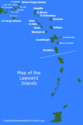
Leeward Islands and the Virgin Islands by tomorrow night. We will have some real information on Maria soon. She's weak, she's a big area of weak weather with some strong winds and she should put

Doesn't sound like an exact science here:

"IT APPEARS THAT MARIA HAS SLOWED DOWN TODAY. SURFACE OBSERVATIONS
SUGGEST THAT THE LOW-LEVEL CENTER...SUCH AS IT IS...IS LOCATED TO
THE SOUTHWEST OF THE MID-LEVEL CENTER SEEN IN VISIBLE SATELLITE
IMAGERY. IT WOULD NOT BE SURPRISING IF THE SURFACE CENTER REFORMS
CLOSER TO THE MID-LEVEL CENTER OVERNIGHT OR ON SATURDAY. IN FACT...
THIS MAY BE WHY THE GLOBAL MODELS SHOW A TRACK FARTHER NORTH ACROSS
THE LEEWARD ISLANDS."

Sounds like a kid trying to explain to his teacher what happened with his homework...


If you ask me she at least has some sort of circulation center and is at least a Tropical Depression. I don't buy a downgrade to a wave, looks better than a wave. A Tropical Storm? Well, it appears.............

Either way her track remains the same, she turns north and misses Florida.

And Katia is going fast out to sea and leaving our side of the Atlantic. Amazingly, no one seems to have told her that she is too far north to still be a Hurricane, she's putting on quite a show up there in the North Atlantic.


Otherwise.... it's going to be a weekend in parts of the North where people are going to clean up after the floods or put together a plan on how they are going to clean up or put together a plan for what to do if their house was washed away and they have no home to go back to... It's a real mess up there and TWC is covering it far better than I could except to say how sorry I am that people have to go through such tragedy.

I don't know why there is this false perception of safety in other parts of the country that disasters only happen in California and Florida. The strongest earthquake ever in the United States was in Missouri/Arkansas and Tennessee in that region where all three come together. Fires and flood happen anywhere. Twisters hit random cities. Terror can find you anywhere you live not just NYC and Washington DC.

We have to be happy and give thanks when our lives our "normal" and they are not torn apart by the misery that tore apart the lives of people living in cities in Vermont or the lives of the families of people whose loved ones died on the planes in 911 or on the ground or at World Trade Center.

So, on this quiet Friday afternoon I am going to finish preparing for the Jewish Sabbath, put some more food up, figure out what to wear to a friend's house for dinner and give thanks that I can sit with friends and family enjoying a meal and appreciating all I have in my life.

I suggest you do the same...whether you gather around a table with your loved ones or go for a walk on the beach or have coffee in a cute coffee bar in a busy city. Enjoy life, give thanks and take a moment to pause and think on the fact that it has been ten years since I sat online with my crazy friend early in the morning, like we did every morning in September discussing the tropics and suddenly my friend stopped typing back... my kids came in and said a plane had hit the World Trade Center and my daughter who had just gotten back from Israel said immediately, "it's terrorism" while my younger kids thought that was crazy, it had to be an accident.

We all remember where we were when we heard that JFK was shot and the younger generation remembers where they were when they heard the planes went into the World Trade Center.

It's humbling and important and more important this weekend than Nate and Maria.

Besos Bobbi

Thursday, September 08, 2011

Maria Remains a TS, Nate is Stationary and Katia is going out to sea...


Nate is caught up temporarily in a weak steering pattern and he is stationary just off the north coast of Mexico creating flooding which may

There is a thought that Nate becomes stuck down there for days, possibly up to a week in the weakest of steering currents. Hard to believe. The only thing certain is that he is holding his own cradled in the Bay of Campeche with no rush to go in any direction anytime soon. At this rate he may be with us longer than Maria

And, as of 11pm Maria is still with us as a Tropical Storm. Despite her weak appearance watches and warnings have been posted for the various islands:

THE METEOROLOGICAL DEPARTMENT OF CURACAO HAS ISSUED A TROPICAL STORM
WARNING FOR THE ISLANDS OF ST. MAARTIN...SABA...AND ST. EUSTATIUS.

THE GOVERNMENT OF ANTIGUA HAS ISSUED A TROPICAL STORM WATCH FOR THE
BRITISH VIRGIN ISLANDS.

A TROPICAL STORM WATCH HAS BEEN ISSUED FOR THE U.S. VIRGIN ISLANDS
AND PUERTO RICO...INCLUDING VIEQUES AND CULEBRA.

Really great I might add to watch NFL Football. Nothing like being properly distracted while waiting for the new discussion to come out than watching Green Bay play New Orleans on TV.

It's easier sometimes to play Fantasy Football and predict the outcome than it is to predict storms that are either stationary like Nate or zooming through the Atlantic like Maria. Got to give the NHC credit, they are working over time for their money this year.

For now, the NHC kept Maria a Tropical Storm. Logic is below, and I agree with that logic.

"DUE TO COMMUNICATIONS PROBLEMS...THE
AIRCRAFT THAT INVESTIGATED MARIA WAS UNABLE TO TRANSMIT A FULL DATA
SET. THEREFORE...IT WAS NOT DETERMINED WITH CERTAINTY WHETHER A
WELL-DEFINED CLOSED CIRCULATION STILL EXISTED. HOWEVER...THE PLANE
MEASURED A CENTRAL PRESSURE OF 1005 MB...SHOWING THAT AT THE VERY
LEAST A LOW PRESSURE CENTER STILL EXISTED. BASED ON THIS...MARIA
IS MAINTAINED AS A TROPICAL CYCLONE. THE INITIAL INTENSITY OF
35 KT IS BASED ON THE AIRCRAFT DATA AND RECENT BUOY REPORTS."

Good Discussion on Maria, it took long enough. Not used to waiting til 11:20 before the 11Pm discussion was posted but it was worth waiting for...

http://www.nhc.noaa.gov/text/refresh/MIATCDAT4+shtml/082051.shtml?


The new cone stays offshore Miami and South Florida, however that could change later "in the forecast period" which is my way of saying you know the drill. She is still a long, long ways away from South Florida but she is moving quickly west at 21 mph forward speed.

So, that's it. Spent the night working on a creative project while watching Green Bay play and it doesn't get better than that. Well, if the Dolphins had been on that would have been better but I'm happy the football season has started. Bring it on...

As for Maria and Nate I can only hope they avoid creating more flooding misery for the U.S. unless they can figure out a way to rain on Texas.

Sweet Tropical Dreams

Bobbi
Ps...To be fair, Maria does have more convection tonight than she has had all day. Does she have a solid center though that is the question. And, more problematic if the center fix is off...so are the models, as the saying goes garbage in ...garbage out. Let's hope we have it right!

The Saga of Maria. Falling Apart or Coming Together ?


BULLETIN
TROPICAL STORM MARIA INTERMEDIATE ADVISORY NUMBER 8A
NWS NATIONAL HURRICANE CENTER MIAMI FL AL142011
200 PM AST THU SEP 08 2011

...MARIA NOT WELL ORGANIZED AT THIS TIME...

SUMMARY OF 200 PM AST...1800 UTC...INFORMATION

The saga of Maria is beginning to sound a lot like a soap opera. The problem is if she doesn't fall apart she could be a big possible threat to South Florida and/or the Carolinas.

Loop the loop and you can see the naked swirl that is Maria moving west bound with convection blowing up but not specifically wrapping around the center.

http://www.ssd.noaa.gov/goes/flt/t3/flash-vis.html

Some models intensify Maria in the Bahamas:

http://moe.met.fsu.edu/cgi-bin/hwrftc2.cgi?time=2011090812-maria14l&field=Sea+Level+Pressure&hour=Animation

The GFS model intensifies both Maria and Nate in a few days:

http://moe.met.fsu.edu/cgi-bin/gfstc2.cgi?time=2011090812&field=Sea+Level+Pressure&hour=Animation

I suppose the real question is how "together" is Maria and can she hang in there long enough past the blast of shear she is fighting as Katia moves out of the picture? If so she's something to watch.

Nate may be stronger than he looks. He may be small, but size does not count here he may be stronger than he looks. Recon has found stronger winds in Nate than they were expecting to find.

Katia is finally moving away.

What I find surprising is that despite Maria's poor satellite presentations that the models really like her, they really, really like her and they show her as a strong hurricane later in the forecast period. Most do anyway...

Stay tuned and see what the NHC do with Maria at 5pm.

Up north, the floods go on and on and on... as the flood waters keep rising in Binghamton and evacuation orders given to 150,000 people in Pennsylvania.

http://www.clevelandleader.com/node/17465

The pattern may change as what appears to be a stronger Arctic looking cold front moves south pushing the somewhat stagnant pattern we have had away and ushering in a cool blast of Autumn Air into the mix.

Speaking of Autumn and Winter, La Nina is back... more on that later.

http://www.cpc.ncep.noaa.gov/products/analysis_monitoring
/enso_advisory/ensodisc.html

Maria and Nate are more pressing problems to ponder...


Easy to kill Maria off at 5, but if they do will she stay dead or come back to haunt us?

Besos Bobbi

Maria, Nate and Katia & Inland Flooding in the US


The story of the day really is the inland flooding far from all 3 of these tropical systems that was caused by a mix of the remnants of Lee and the trough that picked up Lee and the tropical dance they did of Caribbean Infusion into a frontal boundary moving through the Mid-Atlantic.

Long sentence to explain that the rain from Lee intensified the amount of moisture and created a tragic scenario that without Lee's remnants would just have been another day of September Rain.

This is directly tied to Lee and it should be a lesson that hopefully many will remember that what happens on the coast of Louisiana can and might effect those living in upstate NY. Lee's butterflies wings were really powerful and devastating. Another reminder that weak tropical systems, tropical storms especially can sometimes cause much wider misery than a small, compact, strong category 1 or 2 hurricane.

It's interesting for me to see the city of Binghamton being covered live on air as I have had many friends in Chabad who were mostly macrobiotics who went to school there years back. There's a big university and a wonderful community that is being impacted today from flooding on the levels the NE has not seen since Agnes. Pennsylvania, Maryland and the later today NYC and New England again will get socked. The legacy of Lee.

I'll say it again and again and again and I discussed it with Bill Read at the NHC during a conference there, always bothers me... inland flooding does not generate the pre-storm hype that landfall does and that needs to be changed. It's something about the way the NWS works, they work in real time. They put it in the long range forecast "watch Lee" but they don't get the attention even locally that the NHC does far away. This really MUST change as conditions locally often happen faster in real time and are more prone to change quicker than a 3 day cone out of the NHC. The NWS's loss was the NHC gain when Bill Read moved to Miami to work for the NHC. I only wish the media paid more attention to inland flooding possibilities before the horse swims through the barn door.

http://www.pressconnects.com/article/20110908/NEWS01/110908025/
Video-from-BU-Event-Center-evacuation-center?odyssey=tab|topnews|img|FRONTPAGE

http://www.pressconnects.com/

In the tropics Maria keeps moving west and it's not a good thing that she is not intensifying, because the weaker she stays the more she moves west. The more chance she will impact land and affect the islands.

At 8 AM the French Islands issued a Tropical Storm Watch for their part of the world. They do their own excellent forecasting and they are very proactive in their watches vs some of the other wait and watch and see attitudes in the Caribbean.

TROPICAL STORM MARIA TROPICAL CYCLONE UPDATE
NWS NATIONAL HURRICANE CENTER MIAMI FL AL142011
800 AM AST THU SEP 08 2011

THE GOVERNMENT OF FRANCE HAS ISSUED A TROPICAL STORM WATCH FOR
MARTINIQUE...GUADELOUPE...ST BARTHELEMY AND ST MARTEEN.


The salient point here is not how strong Maria is now, or if she does or doesn't have a closed circulation as the NHC is implying (boy would they love to downgrade her) but what she will do tomorrow. A weak, insipid upper level low has been moving out ahead of her and keeping her development in check the last few days. That is expected to move away and leave Maria in a position to strengthen in a few days when she is much closer to the islands. Until then, she is going to ride the southern edge of the Atlantic high and keep moving west. Many a storm has had this set up and often when the upper level low gets out of it's way it intensifies rapidly. This worries me more than if Maria was getting stronger and pulling north more. With every new advisory you will see her cone moved further and further west. More an Emily scenario than her sisters Irene and Katia in that she is developing slower and having problems pulling it together and if so she may come in further west than both Irene and Katia. BUT, she should miss the United States and curve north like Irene and Katia before her.

NOTE.... at some point this scenario is going to change and as we still have storms coming off of Africa, this is not a lock on future forecasted tracks. It is what it is today in early September, late September may be a different set up as things become more fluid later as we approach Autumn, true Autumn not meteorological Autumn which started on September 1st, the real autumn when fronts dip down more and sometimes the door to the north gets blocked by ridging that moves in deep after a cold front moves off the east coast further south.

So stay tuned as Ophelia is waiting in the wings, probably in the form of a Cape Verde Wave that recently exited the African Coast.


The Good News with Nate is the door is opening for a possible northward track towards Texas. The BAD NEWS is that if he goes too far east he could hit the same area Lee did and cause the same trouble Lee did. Right now, if this was a Magic 8 Ball it would read "Try Again Later" as there are just too many possible scenarios even though the NHC is officially going with the shuffle off to Mexico track.

Stay tuned and contribute generously to the Red Cross or any charity of your choice in the affected areas as the natural disasters of 2011 just keep rolling in... if only money and charity could roll in as fast to help the survivors of this messy weather year which will go down in history for record rainfall and record floods after a winter that didn't stop with record snowfall. Beginning to make me wonder what this coming winter will bring up north and how fast it will or won't come on.

But, hey that's Bastardi's territory not mine, I just follow the tropics.

Besos Bobbi

Ps... Last night while watching TWC after the debate, one of the on air meteorologists said and I quote "The flash flooding happened really suddenly" and I just stared... she's not Stephanie Abrams or Jim Cantore, that's for sure... yup, that's why they call it "flash flooding" . . .

Wednesday, September 07, 2011

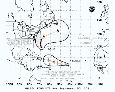
2 New Storms: Nat & Maria Join Katia In the Tropics


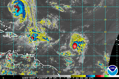
Nate is the circle that says 70% as the NHC has been slow to update their graphics, they've been busy... it will all get up there soon.


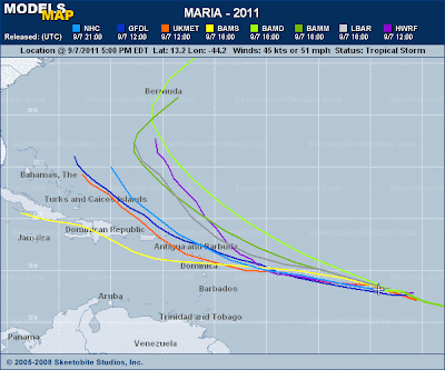
Oddly the only one that is close enough to cause trouble to land is the very unimpressive Nate who is hovering just offshore the Yucatan. So, since cities there may be affected I'll deal with Nate first. www.skeetobiteweather.com did a great job putting together the up closer and personal track map that is posted above. Kudos, really...they are marvelous!

A slow mover, lots of rain and a strong signature on the "juice loop" despite a poor presentation on satellite imagery. Most likely will move north. Not north enough to put out the fires in Texas but north just the same. Maybe one big group prayer here? So far, looks to go north and then curve off to the west towards Mexico. That could change as it's just formed, but I think the pattern is pretty set.

http://tropic.ssec.wisc.edu/real-time/mimic-tpw/natl/anim/latest72hrs.gif


Maria was given her name earlier today at 11. She's a nice storm to look at and developing carefully and most likely going to follow Katia and Irene out to sea. Might make a run for the islands and make a few people in Miami and the Bahamas nervous but they seem pretty set on her making the turn. She is a fast mover.

LOCATION...13.2N 44.2W
ABOUT 1205 MI...1935 KM E OF THE LEEWARD ISLANDS
MAXIMUM SUSTAINED WINDS...50 MPH...85 KM/H
PRESENT MOVEMENT...W OR 275 DEGREES AT 23 MPH...37 KM/H
MINIMUM CENTRAL PRESSURE...1002 MB...29.59 INCHES

That is indeed what we call racing through the tropics. Such a fast moving storm might take a little longer to make a turn and she could get further west than expected but those questions won't be answered just yet. For now they have her recurving out to sea. Let's see.. at this point she make overtake Katia who is moving ever so slowly in the Atlantic. To me Katia looks like she is moving slower than 10 mph and I figure they are hoping she will move 10 mph. My question with Katia would be why is she moving so slowly out to sea....


The models for Maria:


Katia meanwhile looks to be spinning about in the Atlantic barely moving.

You be the judge:

http://www.ssd.noaa.gov/goes/east/watl/flash-avn.html

I don't know, she looks like she is barely moving, just spinning on her own axis but the forecast is all about forecasted movement and she is forecast to grab her ride out of town soon. Time will tell. Puzzles me that she just sits there and everyone ignores it but well, the models show her moving away....


Well, it's a complicated busy picture out there. If you like to take your sailboat out on trips you might want to avoid these areas:


That's a lot of watery real estate on that map.


Elsewhere, there is a system that lies between Katia and Maria that is being watched. The moisture from that area is being tapped by Katia currently and she has sucked the energy out of it but it's possible it could develop. If so and if not it make you wonder if there could be some interaction between the three systems that the models are not taking into consideration. One... Katia is barely moving, Maria is racing and Nate is just feeling his groove.

Busy night for the guys at the NHC. No games tonight for those boys, they've got a lot of forecasting to do.

As for me...I'm watching. Making Maple Flavored Acorn Squash for dinner with Indian something over pink rice and just sitting here watching the tropics spin.

So much out there...and thankfully not that much headed towards a date with destiny as much as swimming with the mermaids and the fishies.

How much longer can our luck last in such a busy hurricane season. The NE is still cleaning up, Lee is still causing storms across the East Coast as his energy is everywhere like some homeopathic storm remedy and parts of him are falling all over the place. Irene left behind a bill of 1.5 Billion dollars and counting.

Sit a spell and watch the tropics spin with all those storms safely far away from us and only Nate causing some problems Mexico.

"THE GOVERNMENT OF MEXICO HAS ISSUED A TROPICAL STORM WARNING FOR THE
COAST OF MEXICO FROM CHILITEPEC TO CELESTUN"

If I could make it rain in Texas I would, if I could, if I only could but the dry air that is causing the problem is keeping the hurricanes away...for now.

Sweet Tropical Dreams,

Bobbi

Tuesday, September 06, 2011

Tropical Depression 14 Forms in the Atlantic
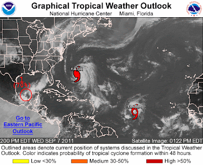


A very healthy tropical depression I may add.

Stay tuned.

LOCATION...11.8N 37.0W
ABOUT 920 MI...1480 KM WSW OF THE CAPE VERDE ISLANDS
ABOUT 1650 MI...2655 KM E OF THE LESSER ANTILLES
MAXIMUM SUSTAINED WINDS...35 MPH...55 KM/H
PRESENT MOVEMENT...WNW OR 285 DEGREES AT 18 MPH...30 KM/H
MINIMUM CENTRAL PRESSURE...1008 MB...29.77 INCHES

Sweet Tropical Dreams...
Bobbi

http://www.youtube.com/watch?v=QPKGLPPjWrs <-- one of my favorite songs

Waiting on Upgrade to TD14 or Maria... Strong Storms in the Carolinas


On the laptop currently as I decided to leave the PC unplugged for a little while longer. Very strong Tstorms nearby and some cells with rotation around the area. Nice to see how Lee oozed his way this way after all. The low that was Lee is still to the south of here, however his moisture is all over the place.

The tropical wave that is unnamed should be named at 5pm. If not then, when?

She's looking pretty serious out in the Atlantic. Models bring her far enough west to start worrying and wondering if she will or if she won't recurve.

Either way the tropics are getting Active with a capital A.

Wind and rain and the threat of tornadoes has been an issue in the Piedmont and the Appalachians. In the Atlantic there are storms trying to form besides "Maria" who currently seems a done deal and is at 90% officially, though unofficially she is being referred to as TD14. Waiting on official confirmation.


So, let's get tracking and figuring out what to do with Maria.

As for anyone who wants to donate to areas already devastated by Irene or Lee, please click on this link and donate generously.

http://www.redcross.org/

Bonus pic, strange angle to look at Katia:


I have friends in the know who worry on this, hoping that low that was Lee knows which way to go and he takes Katia with him out to sea...


Besos Bobbi

Monday, September 05, 2011

Category 4 Katia & Soon to be Maria...


Just updating y'all before going to bed, because it's not every day you get a Category FOUR Hurricane out there in the wide open Atlantic. I would think that the stronger she gets the more likely she is to move poleward (north), however sometimes funky things happen with such a strong storm. But, would assure a trip out to sea and don't think she will be a Cat 4 very long.

It's amazing that she is such a strong storm considering she is battling some shear on her NE side and the water there is minimal to support such a storm....however she is there and going strong.

Maria will most likely form tomorrow in the Central Atlantic, or at least become a tropical depression.

A new area in the Gulf of Mexico may pop up, however I'm skeptical and as much as I would love to wish rain on Texas the dry air that is filtering down into the Western side of the Gulf is not conducive to tropical development, still the models are whispering development. I do think in a week or so there will be something there.

Most intriguing is that there is one of those long thin leash sort of visual images from Katia back to the wave that will be Maria.

Then again, Katia being a Category 4 may dampen the tropical wave a bit. Tropical weather is all about transference of energy from the tropics to the poles and hard to ramp up while Katia is exploding. Then again........the longer it takes for "Maria" if she is in the Atlantic to form will keep her further west longer and well... that's not something to laugh at..

Nite... Sweet Tropical Dreams, BobbiStorm

http://tropic.ssec.wisc.edu/real-time/mimic-tpw/natl/anim/latest72hrs.gif


http://www.ssd.noaa.gov/goes/flt/t2/flash-rb.html

Great loop to watch...