Hurricane Harbor

A writer and a tropical muse. A funky Lubavitcher who enjoys watching the weather, hurricanes, listening to music while enjoying life with a sense of humor and trying to make sense of it all!

Tuesday, August 31, 2010

Map of Uncertainty


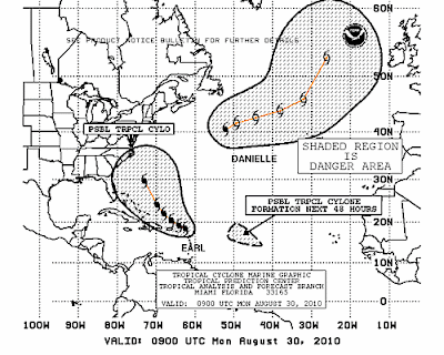
Now that's a big, wide map of uncertainty. Seriously. It encompasses most of the state of NC, all of Maryland... NJ... well you look and see if your home town or friend's home town is in it for yourself.

I have rarely seen a grid so WIDE and I respect the Navy site more than the NHC site in ways.. and often the NHC's site is updated later to correlate with this one so cannot wait to see what they will do at 11.

The problem is that the storm will be moving SOOO fast that there is not the normal lag time to wait and put out a watch or warning for most of the Mid-Atlantic and NE.

Perfect looking storm...should be a Cat 5 or borderline... as strong as Andrew was on approach and no one is certain where it is going to go... we are all wishcasters today trying to wish this storm away....


Much to think on... much to do...

Besos Bobbi

Earl Tuesday Morning, Fiona and "Gaston" out there somewhere


This is one of those mornings that you wake up and look at the satellite image and think holy crap....what the hell is that??

Then you look at the cone and see you have nothing to worry about, because it's going to go somewhere else.... you hope.


And....you gotta believe but you gotta keep watching, it's that simple. You have to walk a tightrope through the mindfield of Tropical Weather Forecasting.

Earl's beginning to get that hedgehog look that some Major Canes get.


Now to look at the bigger picture....


That's some picture isn't it?

Animate it....it gets funkier:

http://cimss.ssec.wisc.edu/tropic2/predict/overshooting_tops/Animation.html

Use this classic tune and remember that they are all rolling along on the trade winds, west bound and one of them will make it further west than the last... we have been so friggin lucky this year so far. At some point, our luck will run out. Because the train is going to keep on rolling, rolling on the tradewinds... the river of air...


If you live anywhere from NC to NY... pay attention and listen to every bit of hype, hype won't hurt you... the hurricane might... worst thing you can do is buy a bunch of snack food and gain five pounds over the next few weeks if Earl bears left out to sea.

Keep watching... going to zumba or stretch or whichever thing is this morning.

Besos Bobbi

Monday, August 30, 2010

Tropical Storm Fiona, born to follow Uncle Earl??


Tropical Storm Fiona formed officially this afternoon while the NHC was busy tracking it's Uncle Earl. Fiona seems at first glance to want to follow in Uncle Earl's footsteps but we need time to wait and see where she goes. Another ocean spinner would make life easier for sure for many.

Update more on Earl in a bit, but think Fiona deserves her day in the sun and fun on the blog.

Official Birth Announcement from the NHC, wonder if they are giving out pink cigars?

TROPICAL STORM CENTER LOCATED NEAR 14.4N 48.7W AT 30/2100Z
POSITION ACCURATE WITHIN 75 NM

PRESENT MOVEMENT TOWARD THE WEST OR 270 DEGREES AT 21 KT

ESTIMATED MINIMUM CENTRAL PRESSURE 1007 MB
MAX SUSTAINED WINDS 35 KT WITH GUSTS TO 45 KT.


I bought a blue betta earlier today, first betta in over a year. I caved, decided I wanted one... needed one..a blue tropical one... will call it Fiona ;)

More later on CATEGORY FOUR Hurricane Earl

Besos Bobbi

Category 3 Hurricane Earl... Moving towards Puerto Rico


Strong bands spiraling in over the north shore of Puerto Rico as I type this... and when I say towards I mean that even if the eye stays north of PR with an expanding, violent storm the storms in the bands have gusts way above hurricane force winds.

Three days ago the forecast went on and on about finding the weakness in the ridge... north of the islands, leeward islands keeping an eye on Earl.

There was no strong talk that Puerto Rico might want to pay very careful attention. Just a lot of CYA talk on low confidence in the forecast track. I'm sorry that is way way WAY too mild language for a hurricane that was forecast to be a Major Cane even then.

One thing I will give the NHC credit for is they got the forecast intensity dead on, even if they messed up on the track a bit.

Why should New Yorkers and people in the Carolinas worry?

Because until Earl takes the turn the turn could and I say ...could...come to late to spare a hit in the Carolinas and with temps in NY and Maine that are running FIFTEEN DEGREES ABOVE their normal high temps they are in a prime position to suck this storm in IF and a very qualified IF the front over the Great Lake does not do what they expect it to or it does too much. It's a very dangerous ballet being played out in real time and when a Cane goes Major and does pull north he can make it from the Outer Banks to NYC in less than 12 hours.

Let me put this into perspective.

24 hours ago no one was worrying on Puerto Rico getting hurricane force winds other than me looking at the wind probs.

What if.... people in NY who don't spend a lot of time reading up online look at some cone and it shows Earl moving out to sea and kissing the tip of Long Island goodbye and possibly flirting with Cape Cod. Most Yankee fans couldn't give a damn about what happens in Boston and they go to bed thinking "I'm out of it" and they wake up to trees going pop in the morning light, things crashing into their windows not boarded up and high surf flooding in Long Island and those parts of Brookyn prone to flooding and wondering WTF happened...

This is not about hyping a storm...this is about worrying on all scenarios, best case and worst case scenarios.

New Yorkers are known ...infamous for walking out on Jets games when their team falls 10 points behind, not a lot of patience there. Red Sox fans will sit in their seats, in the cold fall staring in beat up coats in Fenway Park waiting for their team to come miraculously from behind and win and even watching them lose is better than not watching them. So ....forgive me if I don't worry on friends in Rhode Island (if they are even there currently) where as I am worried on New Yorkers... even Yankee fan New Yorkers ;)

This is NOT the storm to have a false sense of security on ...not in a long range track that can vary by 200 plus miles 3 days away and it will take less than a day, less than half a day to veer in to the left and slam into parts of NY and Long Island and cruise right into Rhode Island and Ct and make memories in Cape Cod...Martha's Vineyard .... I mean... the 1939 Hurricane DID happen, I know because I watched "Portrait of Jennie" when young on Channel 6 in Miami.

It's Labor Day Weekend... do not go away early, wait until Earl passes safely offshore.

Watch the news, the radio and pay attention...and for all of you with family out there up north, tell them to pay attention.


Sorry...best I could do, not as nice as the pretty yellow one from when you punked me.. but it's Martha's Vineyard just the same ...and for my kids in the NY area, this is not a Miami Tropical Event...it's fast moving and there is not a lot of time to prepare unless you prepare now...

This is supposed to hit Cat 4 before the day is over.

I'd like to see that turn happen yesterday....

An Upper Level Low that came off the backside of Danielle helped intensify Earl.

Damage is happening in the Virgin Islands, seen it on webcams that are still up and power is out in many places. Although it is moving more to the WNW it's core is expanding and therefore the little bit extra distance might not help as the storms in the bands are far from the center of intensifying Earl.


Again, for this storm please use the 123 Mariners Rule rather than the 5 Day Cone. Just my advice. With a Category 3 or 4 or even 5 storm a miss is mot as good as a mile, a miss can cause tremendous damage from strong storms in the bands far away or near by but when you didn't "officially get the storm" so stay on top of this.

Learn how to use the wind prob page of the NHC forecast:
http://www.nhc.noaa.gov/text/refresh/MIAPWSAT2+shtml/301445.shtml

NANTUCKET MA 34 X X( X) X( X) X( X) X( X) 16(16) 31(47)
NANTUCKET MA 50 X X( X) X( X) X( X) X( X) 4( 4) 22(26)
NANTUCKET MA 64 X X( X) X( X) X( X) X( X) 1( 1) 13(14)

PROVIDENCE RI 34 X X( X) X( X) X( X) X( X) 12(12) 21(33)
PROVIDENCE RI 50 X X( X) X( X) X( X) X( X) 2( 2) 13(15)
PROVIDENCE RI 64 X X( X) X( X) X( X) X( X) X( X) 7( 7)

HARTFORD CT 34 X X( X) X( X) X( X) X( X) 10(10) 13(23)
HARTFORD CT 50 X X( X) X( X) X( X) X( X) 1( 1) 6( 7)
HARTFORD CT 64 X X( X) X( X) X( X) X( X) X( X) 2( 2)

MONTAUK POINT 34 X X( X) X( X) X( X) X( X) 18(18) 17(35)
MONTAUK POINT 50 X X( X) X( X) X( X) X( X) 3( 3) 13(16)
MONTAUK POINT 64 X X( X) X( X) X( X) X( X) 1( 1) 7( 8)

NEW YORK CITY 34 X X( X) X( X) X( X) X( X) 14(14) 7(21)
NEW YORK CITY 50 X X( X) X( X) X( X) X( X) 3( 3) 4( 7)
NEW YORK CITY 64 X X( X) X( X) X( X) X( X) 1( 1) 1( 2)

NEWARK NJ 34 X X( X) X( X) X( X) X( X) 12(12) 6(18)
NEWARK NJ 50 X X( X) X( X) X( X) X( X) 3( 3) 2( 5)
NEWARK NJ 64 X X( X) X( X) X( X) X( X) 1( 1) X( 1)

ATLANTIC CITY 34 X X( X) X( X) X( X) X( X) 18(18) 4(22)

BALTIMORE MD 34 X X( X) X( X) X( X) X( X) 9( 9) 1(10)

WASHINGTON DC 34 X X( X) X( X) X( X) X( X) 9( 9) X( 9)

OCEAN CITY MD 34 X X( X) X( X) X( X) X( X) 22(22) 3(25)

RICHMOND VA 34 X X( X) X( X) X( X) X( X) 11(11) X(11)

NORFOLK NAS 34 X X( X) X( X) X( X) 1( 1) 18(19) X(19)

RALEIGH NC 34 X X( X) X( X) X( X) X( X) 6( 6) X( 6)

CAPE HATTERAS 64 X X( X) X( X) X( X) 1( 1) 8( 9) X( 9)

MOREHEAD CITY 34 X X( X) X( X) X( X) 6( 6) 16(22) X(22)

WILMINGTON NC 34 X X( X) X( X) X( X) 3( 3) 9(12) X(12)

Loops to use:

http://radar.weather.gov/ridge/radar.php?product=N0Z&rid=JUA&loop=yes

http://www.atmos.washington.edu/~ovens/loops/wxloop.cgi?wv_east_enhanced+6

cam: http://www.stjohnspice.com/stjohnspicecam.htm

others at stormcarib.com and hurricanecity.com

Will be in touch .... will update later... right now watching the loops and talking to friends tracking and preparing to chase.

Besos Bobbi

Intensifying, Mystifying Earl


Earl is intensifying while he plays down in the Virgin Islands about to take a Jetblue flight for the NE, with a possible stop in Wilmington or some airport that Jetblue serves in that area. Possible stop I said.

He has been consistently left of forecast .... left of every forecast.

The Virgin Islands and the other islands that it was supposed to pass to the right of are now getting Earl. Great loop from yesterday that a friend sent me of yesterday's movement towards the islands. Shows how it got further west than forecast.

http://einstein.atmos.colostate.edu/~mcnoldy/tropics/earl10/Earl_29Aug10.gif

As they said themselves there is low confidence in their long term forecast that can be off by up to 300 miles or so as stated in their 5 AM Discussion. See below:

THIS IS A GOOD TIME TO REMIND EVERYONE THAT NHC AVERAGE TRACK
FORECAST ERRORS ARE 200 TO 300 MILES AT DAYS 4 AND 5. GIVEN THIS
UNCERTAINTY...IT IS TOO SOON TO DETERMINE WHAT...IF ANY...PARTS OF
THE U.S. EAST COAST MIGHT SEE DIRECT IMPACTS FROM EARL LATER THIS
WEEK.


The picture above is the Virgin Islands being affected by Earl.

Since the NHC themselves feels they cannot trust their own forecast right now out beyond 3 days I am going to use for Earl their 1 2 3 chart below.


EVERYONE in the NE should pay close attention to this storm from NY to Cape Cod and I don't mean Long Island I mean NY, the NYC metro area as well. Maybe even Cape May north...

Why? Strong storms at that lat move very, very fast and can get from point A to point B while you are sleeping.

The VI had little time to deal with a Hurricane Warning, as they upgraded the watch at the last minute. True...they were told to watch but a big difference between a "watch" and a "warning" in people's minds who are used to hurricanes being watched.

Will post more after the 11 am.

On a personal level I was at the beach yesterday... didn't see the big waves that I heard about tho the undertow was wicked. Didn't take that many pics, was not something to take pics of as much as to enjoy and feel, walked ankle deep in water and got slammed by low rollers up to my knees.... heavy strong surf and the water was VERY VERY VERY Warm for the Outer Banks... VERY. Mostly I kept thinking this would supply strong fuel for a major Cane. So, a bit sunburned and catching up to speed in the world of loops... thank you so much everyone who kept feeding me what the loops were showing ;) and was a fun drive...

Besos Bobbi
Ps Fiona should start to get her name later today and use http://www.stormcarib.com/ as your guide for the next few hours for the best reports from the locals, they do a fantastic job!

Sunday, August 29, 2010

Hurricane Earl Moving West....

Keep watching the trof.....the ridge.... the models which have been more consistent with Earl than Fiona to be... last night Fiona took Charleston off the map and this morning it's aiming at Ft. Lauderdale and Palm Beach... will see.

Count the degrees he pulls north in the next 12 hours...

But for now... he's going west... and I am going east....to the beach...

chow for now

Bobbi

loop this loop to this great song ;)

http://www.ssd.noaa.gov/goes/east/tatl/flash-wv.html


Know this storm could scrape up along the Florida Coast and then slam into some city without clipping Cape Hat ... could not saying it will... just saying it could.

Sunday Morning ...Reality Bites.....HURRICANE EARL HEADED FOR THE NORTHERN LEEWARD ISLANDS...


All the forecasting and wishcasting and hoping and insisting and Hurricane Earl is headed into towards the Leeward Islands.

It's that simple.

This is why people are paranoid (for good reason) about Hurricanes and forecasted track. Because often they get shifted and shifted until the everything's changed and then the hurricane is said to come within the parameters of the track forecast which it did do because they kept shifting the track. It's a slippery slope once you do that and with a storm like Earl it makes it worrisome for future forecasts.

Why? Because the NHC is so bad at what they do? No... no they are good. The problem is Earl's real center has been neatly hidden and oozing around in a large pocket of moisture which this year's in term is "pouch" and when he starts to crank up he is going to be one BIG HUGE storm... if he does and I believe he will so we need to watch him carefully.

This is discussion from less than 48 hours ago... notice where Earl's position is supposed to be in 120 hours.

ALTHOUGH THERE IS A LARGE CIRCULATION...THE CENTER IS DIFFICULT TO
LOCATE. USING ENHANCED SATELLITE IMAGERY AND MICROWAVE DATA...THE
BEST ESTIMATE OF THE INITIAL MOTION IS 280 DEGREES AT 15 KNOTS.
EARL IS TRAPPED SOUTH OF A STRONG SUBTROPICAL RIDGE EXTENDING FROM
AFRICA WESTWARD TO NEAR 60 DEGREES WEST. THIS PATTERN WILL KEEP THE
CYCLONE ON A GENERAL WESTWARD TRACK FOR THE NEXT 3 DAYS OR SO. EARL
SHOULD THEN BEGIN TO TURN MORE TO THE WEST-NORTHWEST AND NORTHWEST
AS IT APPROACHES 60W WHERE THERE IS A PERSISTENT WEAKNESS IN THE
SUBTROPICAL RIDGE. MOST OF THE TRACK MODELS ARE IN REMARKABLY GOOD
AGREEMENT AND THE OFFICIAL FORECAST IS IN THE MIDDLE OF THE GUIDANCE
ENVELOPE...BUT BIASED TO THE RELIABLE GFS AND ECMWF MODELS.


FORECAST POSITIONS AND MAX WINDS

INITIAL 27/0300Z 15.5N 40.2W 40 KT
12HR VT 27/1200Z 16.0N 42.8W 40 KT
24HR VT 28/0000Z 16.3N 46.0W 45 KT
36HR VT 28/1200Z 16.5N 49.3W 55 KT
48HR VT 29/0000Z 16.7N 52.5W 65 KT
72HR VT 30/0000Z 18.5N 58.0W 75 KT
96HR VT 31/0000Z 21.0N 62.0W 85 KT
120HR VT 01/0000Z 24.0N 65.0W 100 KT


Where is Earl today??

LOCATION...17.1N 57.6W

He is always west of the projected forecast point. He has always taken the bottom side of the cone and remember that can change but for now we have to be careful and believe he is going to continue to so so until we can see a really, nice, STRONG, front waving lots of red color on a satellite loop like a matador trying to attract a bull nicknamed Earl.

Check the archive maps on Earl from the NHC

Where is he going tomorrow??


http://www.nhc.noaa.gov/archive/2010/graphics/al07/loop_3NLW.shtml

Earl seems to be everyone's storm.. people in the Carolinas are watching, people in Florida are watching and people in the Northern Leeward Islands are no longer watching they are boarding up as Earl is headed towards the Northern Leeward Islands.

A friend IMed me last night to tell me she is SURE it's a Miami storm. Local media along the Carolinas are watching carefully. Hell... bet Meteorologists in Cuba are watching and the mets I know are looking more and more "ummmm" and singing the "we think it will find the weakness in the ridge shuffle" and when asked... I would say it will find the weakness too but when and where...

I have a house guest named Doug, God Bless Him. He is hopefully in remission from cancer though I am not sure on the remission as he doesn't like to talk about it much. He said goodbye after lunch on Shabbos and said he wouldn't see me for a a long, long time as he is hitting the road and going to see family for a few months. Twenty minutes later he was back, seems the other house he is staying at had locked the doors and he couldn't get in. We ate dinner. He left, said goodbye. He is leaving for Canada as soon as he gets up. He is sleeping now in the guest room as I type this after saying "goodbye" three times. He will leave, but I'm thinking at the moment he is a lot like Earl. Stubborn, determined, fighting off shear and going to catch that weakness in the ridge... really, soon... any day...

Timing is everything with Hurricanes and life.

As for me I am straightening my bangs, we are having brunch and I am going to the beach. Hitting the road.

Leaving you with this nice tune that an old friend sent me when I couldn't find a song to illustrate something a few years back, nice to have someone still on my side and from the bottom of my heart.. Thank You.


Can't see the future but I know it's coming fast...and so is Earl but hey he's supposed to slow down and catch that break in the ridge, then again timing is everything and had life gone differently I'd be on a road trip with someone else today and not listening to his music. Giggling, okay that was bad but he definitely deserves it lol.

Will post from the road....somewhere... trying to enjoy this area before I leave and before Earl or Fiona... wipes if off the map. And, hey I am taking the hotel gift card with me ;)and sometimes the future is not that easy to predict...not sure where we are going but somewhere to watch the waves and watch the sunset ;)

Love and Kisses... Besos Bobbi

Saturday, August 28, 2010

A Few Analog Years to ...think on...


While going through a book or two today I looked to find years when two storms were in a similar pattern and tried to find some parallels. Not as easy to find as you would think.

First off you need a busy year with storms close together that made a track thru the Atlantic close to the coast vs out to sea or across Florida like Frances and Jeanne.

Interesting comparison of the year Hazel hit North Carolina and kept on going and 1899.

Note here the purpose of this is to show patterns... years with one storm that stays inside the lines and the one that colors outside the lines. Point...something changes. This August the United States was safe from a hit, this September it will not be safe.

History teaches us lessons. Learn from history... and this is a history lesson in hurricanes that have some similarities to the set up this year with Danielle and Earl and Fiona down the line...


1954


1899


Similar corridors up from the Caribbean that allowed the storms to go north and keep going rather than out to sea.


Then we have years like 1898 that is a little bit similar. Note the earlier storm took off and curved out to sea. The high obviously built in and patterns changed and the Storm #7 didn't... See Jax DOES get hit...

Storm 4


Storm 7


Another interesting year is 1998... yup, fast forward 100 years...

Danielle (another ocean spinner)


Georges (another storm in a rush to go west)


In 1989 we have a year with two storms that traced the Bermuda High and the then one didn't... Hugo who slammed into the Carolinas and never turned back...


Dean


Gabrielle


HUGO


Oh look...the European remakes Euro on it's 10 Day Forecast..never believe a 10 day forecast but it does make you go .....ouch....


Edouardo or however you spell the stupid name


Then come Ted.. oops lol it's late sorry.. meant FRAN


And, lastly here is a pic of the whole entire year of 1926.. a year that brought us many intense landfalling storms, many that went out to sea, a lot that traced each other and the ever beautiful Marilyn Monroe ;)


So, where does that lead us? Tonight at 1 AM? Leaves me on IM with a hurricane friend lol...and writing and going to take some tequilla and go to bed :)

Well, the lead story on Raleigh news is the tropics and watching Earl.

Salient Part of the very well written 11 PM Discussion:

THE INITIAL MOTION IS 280/17. EARL IS APPROACHING THE END OF A
LOW/MID-LEVEL RIDGE SEPARATING IT FROM HURRICANE DANIELLE...WITH
WATER VAPOR IMAGERY SHOWING AN UPPER-LEVEL TROUGH JUST NORTH OF
CUBA AND HISPANIOLA. THE LARGE-SCALE MODELS FORECAST A LOW-LEVEL
RIDGE TO BUILD TO THE NORTH OF EARL DURING THE NEXT 48-72 HR...
WHILE THE TROUGH REMAINS NEARLY STATIONARY AND POSSIBLY
STRENGTHENS. THE LOW-LEVEL RIDGE WILL STEER EARL GENERALLY TOWARD
THE WEST-NORTHWEST OR WEST WITH SOME DECREASE IN FORWARD
SPEED...

Compare the wind probabilities for PR and the VI Islands at 5 and 11:

5PM
SAN JUAN 34 X X( X) 3( 3) 9(12) 26(38) 2(40) X(40)
SAN JUAN 50 X X( X) X( X) 2( 2) 13(15) 1(16) X(16)
SAN JUAN 64 X X( X) X( X) X( X) 8( 8) 1( 9) X( 9)

SAINT THOMAS 34 X X( X) 6( 6) 24(30) 20(50) 1(51) X(51)
SAINT THOMAS 50 X X( X) X( X) 9( 9) 15(24) 1(25) X(25)
SAINT THOMAS 64 X X( X) X( X) 3( 3) 10(13) X(13) X(13)

11PM

SAN JUAN 34 X X( X) 5( 5) 16(21) 19(40) 1(41) X(41)
SAN JUAN 50 X X( X) X( X) 3( 3) 13(16) X(16) 1(17)
SAN JUAN 64 X X( X) X( X) 1( 1) 7( 8) X( 8) X( 8)

SAINT THOMAS 34 X 1( 1) 10(11) 31(42) 13(55) X(55) X(55)
SAINT THOMAS 50 X X( X) 1( 1) 15(16) 13(29) X(29) X(29)
SAINT THOMAS 64 X X( X) X( X) 6( 6) 9(15) X(15) X(15)

Find your city of choice:

http://www.nhc.noaa.gov/text/refresh/MIAPWSAT2+shtml/290303.shtml?

(note no Florida cities are in this at 11, watch carefully if anything changes at 5 am)

Watches and warnings are up for ports of call everywhere in the path of Earl.

Personally, I find it hard to believe he doesn't get to 75 W before doing ...something.

Whatcha gonna do now Earl???

Sweet Tropical Dreams

Bobbi

Trying to Catch Up With Earl


Came out of shabbos and am trying to catch up with Earl which is not easy as he spent the whole day being Speedy Gonzalez and the NHC tried to find 50 different ways to say he is moving really, really fast. The problem with the speed is that he is far to the SW of where he was projected to be by the models and therefore Danielle could have less of a long term effect on him though she will tug him a bit.

Loop of the same image from above shows how this goes when put in motion :)

http://www.ssd.noaa.gov/goes/east/catl/flash-ft.html

Recon was in today so hopefully we now know exactly where his center is and which way he is going and at 11 we can have a forecast that we can feel confident about.

He is going to come in under the 20/60 golden box that defines storms that affect Florida under different conditions, there are more disclaimers to this rule than would be believed but we watch that 20/60 line carefully. Here is an incredibly well put together explanation about the Hebert Box and some info on the amazing meteorologist who we owe much gratitude to as hurricanes is meteorology and meteorology is all math and odds, percentages, probabilities and patterns.


http://www.hurricanecity.com/hebertbox.htm

And, trying to catch up with models and their ever conflicting outputs.

Check this one out for instance...

http://moe.met.fsu.edu/cgi-bin/hwrftc2.cgi?time=2010082818-invest97l&field=Sea+Level+Pressure&hour=Animation

Which was run on the wave behind Earl which is different from the SAME model on Earl..

http://moe.met.fsu.edu/cgi-bin/hwrftc2.cgi?time=2010082818-invest97l&field=Sea+Level+Pressure&hour=Animation

One of those mysteries of life, sort of like having the two different answers to the same question by the same professor.

A simple illustration of how hard it is to write a forecast from the NHC that does not sound like it's been cut and paste is below.

These are the various comments I am reading thru...

..EARL CONTINUES WESTWARD...A LITTLE STRONGER...
...EARL CONTINUES QUICKLY WESTWARD...
...EARL CONTINUES HEADING WESTWARD AT A GOOD CLIP...
...EARL A LITTLE WEAKER...ACCELERATING WESTWARD ACROSS THE TROPICAL ATLANTIC...
...EARL HEADING TOWARD THE LEEWARD ISLANDS IN A HURRY..

Then we have the "going to near the a break in the ridge" discussion repeated over and over in every discussion...

THEREAFTER...THE CYCLONE IS EXPECTED TO NEAR A BREAK IN THE
RIDGE...AND THAT SHOULD CAUSE A TURN TO THE NORTHWEST.

and again in the next discussion...

IN A DAY OR SO...EARL WILL BE APPROACHING THE WESTERN
EDGE OF THE RIDGE AND THE CYCLONE SHOULD BEGIN TO TURN MORE TO THE
WEST-NORTHWEST AND NORTHWEST. (uh oh..notice they are hedging on the nw...)

and then again....

...THE CYCLONE WILL BE
APPROACHING THE WESTERN EDGE OF THE SUBTROPICAL RIDGE AND BEGIN TO
TURN MORE TO THE WEST-NORTHWEST WITH A DECREASE IN FORWARD SPEED.

Mind you... he will at some point hit the edge of the ridge... point is where and how much and how fast will he turn and in what direction. I mean Georges never listened to his discussions but that was a different year. Similar tho...

I am not making this up you can check the NHC's Advisory Archives:

http://www.nhc.noaa.gov/archive/2010/EARL.shtml?

Okay, so you are wondering what I am thinking... I am thinking that we will know in about 12 to 24 hours if this is a storm that Florida or the Carolinas will have to worry on and I am leaning towards the Carolinas but you cannot take Florida out of the picture. Looked through some old books today given to be my a friend at the NHC, great maps... of every year going back so far it's amazing and I both realized I didn't update it the way I was supposed to at the end of each year and I found old great hurricane maps I printed out from the Keynoter in Key West several years back. Also, read up on infamous Carolina storms like the 1899 San Ciriaco Hurricane and the 1928 Palm Beach Hurricane as well as a few others. What is so interesting is how similar the tracks are and how the smallest variation in direction and speed made all the difference.

http://en.wikipedia.org/wiki/1893_Sea_Islands_hurricane
http://en.wikipedia.org/wiki/1899_San_Ciriaco_hurricane
http://en.wikipedia.org/wiki/File:1926_Nassau_Hurricane_track.png
http://en.wikipedia.org/wiki/1926_Miami_hurricane
http://en.wikipedia.org/wiki/1928_Okeechobee_hurricane
http://en.wikipedia.org/wiki/1944_Great_Atlantic_Hurricane
http://en.wikipedia.org/wiki/1949_Florida_hurricane
http://en.wikipedia.org/wiki/File:Cleo_1964_track.png
http://en.wikipedia.org/wiki/Hurricane_Georges
http://en.wikipedia.org/wiki/File:Floyd_1999_track.png
http://en.wikipedia.org/wiki/File:Fran_1996_track.png
http://en.wikipedia.org/wiki/Hurricane_Hugo

Note... ALL these storms were at some point where Earl is... and could be fit into Earl's current cone... it all comes down to where the high builds in after Danielle, how much Danielle tugs Earl and where there is a front and etc, etc...

Cape Verde storms... up and over the islands or through the islands and a sharp veer off to the right (north) and up towards the coast or out to sea.

The above listed storms are the ones that did not get away....

Will Earl get away or will he get trapped under a high and move ever so much closer to Florida, before possibly doing the Carolinas.

I'm not even going to discuss Fiona for now and as for Danielle... she is a very beautiful, powerful, intense storm that will add to the list of Danielle's who spun out in the ocean and out to sea without hitting land. Something interesting to note is the D storm went out to sea.. the F storm did not, the high built in at some point.

http://en.wikipedia.org/wiki/File:Danielle_1998_track.png
http://en.wikipedia.org/wiki/File:Georges_1998_track.png

Other than going to the west of Bermuda it's a very similar track and storm.

So, waiting for the 11 pm discussion and hoping now that the planes have been inside and they have studied some of the data that we will have a better handle on Earl. Also, thinking I will pretty much be in the cone as the Navy site has me in the cone.

Might update in a little while after thinking a bit, but for now am thinking if he takes the islands or doesn't may be the defining signature of Earl.

Stay tuned... he is moving westward fast and will soon reach the edge of the...

Besos Bobbi ;)

Friday, August 27, 2010

Apologies From Avila at 5PM... Earl Discussion


Interesting, strange discussion out of the NHC this afternoon at 5.. Avila admits he might have been slow. "IT APPEARS THAT I WAS EITHER SLOW THIS MORNING OR EARL HAS
ACCELERATED A LITTLE BIT."

Personally, I looked at the loops and the advisory and I was pretty sure he was moving west, fast around 20mph forward speed. Maybe he is in a rush to become a Major Cane, am sure he has read his publicity releases!!

Gets a little sketchier here... " I FEEL A LITTLE MORE CERTAIN WITH THE
NORTHWESTWARD TURN IN THIS FORECAST SINCE ALL TRACK GUIDANCE
UNANIMOUSLY BEGIN TO MOVE EARL ON A MORE WEST-NORTHWESTERLY COURSE
BY 48 HOURS. HOWEVER...A DEVIATION TO THE SOUTH OF THE CURRENT
FORECAST TRACK COULD BRING EARL INTO THE NORTHERN LEEWARD ISLANDS.
WITH THE WEEKEND COMING...RESIDENTS IN THESE ISLANDS SHOULD MONITOR
THE PROGRESS OF EARL."

You know rarely do you read so much "I" put into a forecast discussion at the NHC unless Avila is writing them. I just find it interesting as it is so different from discussion by Stacey Stewart (one of the best) or Jack Beven or Brennan.. Suppose that is just his literary style and hey he did apologize, guess he didn't get his Cuban coffee this morning. I know how funky I feel when I miss my cafecito :( really, life is not the same.

Well... the islands of French Saint Martin and Saint Barthelemy have had enough it seems of Avila's indecision and they hoisted a watch for the islands, just in case it turns a little bit to the left (South) and noticed that TWC is now giving out their OWN forecasts "exclusive" and I suppose that means they can differ from the NHC. Sometimes you just got to choose who you going to trust?

Watches up... we will know have advisories on Earl every three hours.

"THE GOVERNMENT OF FRANCE HAS ISSUED A TROPICAL STORM WATCH FOR
FRENCH SAINT MARTIN AND SAINT BARTHELEMY. THIS TROPICAL STORM WATCH
MEANS THAT TROPICAL STORM CONDITIONS ARE POSSIBLE WITHIN 72 HOURS."

Wind probabilities from the NHC are getting higher and higher. A watch is just a watch... reminds people to keep watching.

SAINT CROIX 34 X X( X) X( X) X( X) 10(10) 7(17) X(17)
SAINT CROIX 50 X X( X) X( X) X( X) 2( 2) 3( 5) X( 5)
SAINT CROIX 64 X X( X) X( X) X( X) 1( 1) 1( 2) X( 2)

SAINT MAARTEN 34 X X( X) X( X) 1( 1) 29(30) 8(38) X(38)
SAINT MAARTEN 50 X X( X) X( X) X( X) 11(11) 5(16) X(16)
SAINT MAARTEN 64 X X( X) X( X) X( X) 3( 3) 4( 7) X( 7)

So... last thoughts on my part?

I think Earl needs to be watched. And, note if Fiona takes her time forming and Danielle departs than Earl could intensify faster but still what is not said in the discussion is that the location of the exact center of Earl has been a question discussed all day by professional mets trying to figure out if his center is decoupling or there are just simply two multiple centers or if this is from dust or if this is because he will not slow down as mentioned in apologies by Avila.

The Mariners 123 Rule put out by the NHC shows Earl coming in on the south side of the infamous 20/60 line. IF so.... he has to be watched carefully as storms that do so tend to be problems on coastlines along Florida and north...

Not saying he is going to make landfall... but I think it's possible he could get past 70w and possibly 75w and if so we are going to pray a lot that he makes that turn. Easy money is on him making the turn... but this isn't some $2 bet to win, place or show it's life and death in the tropics.

Keep watching

ST KITTS-NEVIS 34 X X( X) X( X) 2( 2) 21(23) 5(28) X(28)
ST KITTS-NEVIS 50 X X( X) X( X) X( X) 8( 8) 2(10) X(10)
ST KITTS-NEVIS 64 X X( X) X( X) X( X) 4( 4) 1( 5) X( 5)

BARBUDA 34 X X( X) X( X) 5( 5) 35(40) 4(44) X(44)
BARBUDA 50 X X( X) X( X) X( X) 16(16) 1(17) 1(18)
BARBUDA 64 X X( X) X( X) X( X) 7( 7) 1( 8) X( 8

Danielle: Doing what she is supposed to do and following the plan more or less. Beautiful storm to watch.

Earl: Big question mark... Will he really do what the models say and intensify wildly and if he does where and when??

Fiona: Doesn't figure into it just yet.

Personal Editorial:
Am SICK to death of hearing about Katrina and New Orleans, it was a horrible, horrible tragedy that the government neglected to stay on top of the problems with the levee, the maintenance and knowing it was considered for years by the government to be the number 1 tragedy that could affect us from a Hurricane and Katrina did not hit New Orleans. It's neglect on the part of the State of Louisiana that they did not have a way to evacuate people out of a city in their state rather than leaving it to New Orleans to handle. I think they should secede like Key West did and make themselves their own republic. And, VERY TIRED of WAVELAND not getting enough coverage because that is where Katrina hit and that city has not received the monies or attention that Nola has and that part of the country is still trying to rebuild. I love New Orleans, it's in my top five cities but am sick of hearing Katrina, Nola, Katrina and Nola and not enough about Waveland.

And... tired of hearing about the Titanic Expedition and I LOVE Titanic trivia, just enough already.

Have a good shabbos... a good weekend... keep watching Earl...

Besos Bobbi
Ps Go Fins!

Friday 3 PM on Hurricane Weekend Watch...


And there is so much to watch. This image above shows us all the players. Without discussion it almost takes your breath away. After reading the Discussion out of the NHC it also almost takes your breath away but more from a giggling and the uneasy realization that they do not know why Danielle wiggled west during the last six hours.

"THE INITIAL MOTION ESTIMATE REMAINS 305/10. DANIELLE HAS MADE A FEW
BRIEF WESTWARD WOBBLES DURING THE PAST FEW HOURS...BUT OVERALL THE
MOTION REMAINS UNCHANGED. THE TRACK WAS NUDGED SLIGHTLY TO THE WEST
THROUGH 36 HOURS MERELY TO ACCOUNT FOR THE SLIGHT WESTWARD POSITION
AT 12Z."

I'm sorry, but although Danielle is going more north of west currently she is not going 305 degrees. That is a forecasted, projected movement. Only time will tell if she does or if she doesn't. I want to know why and nowhere did that discussion tell me why. And, a "brief westward wobble" is 2 hours, a few frames... not close to 4 or 5 hours. Even that much of a wobble needs to be explained.

Incredible loop:

http://www.atmos.washington.edu/~ovens/loops/wxloop.cgi?wv_east_enhanced+12

Incredible pic:


And... my question is how does Earl become a Category Four Hurricane while the outflow from Danielle is beating down on him in real time? I mean ... if Danielle takes off like a bat out of hell I can see it, but will she?

Nice loop... good song....

http://www.esl.lsu.edu/animate/goes/index.php?region=tropics&channel=wv


See, I have serious problems with an 11 AM Discussion on Earl that basically says that the NHC has no real idea for sure...where he will be after 48 hours and throws in a CYA sort of discussion.

In the old days before models were almost foolproof we used to watch the wind probs. When they continued to go up somewhere the theory was there was more of a chance that the storm could pull in that direction. When Miami's probabilities went up we knew we had to be careful and not turn our back on a storm that was forecast to go to the Carolinas.

Earl at 11 has the following probs for strong wind over the next few days in ports of call far to the south of his expected forecast plot:

SAINT CROIX 34 X X( X) X( X) X( X) 3( 3) 13(16) 2(18)
SAINT CROIX 50 X X( X) X( X) X( X) X( X) 5( 5) 1( 6)
SAINT CROIX 64 X X( X) X( X) X( X) X( X) 3( 3) X( 3)

SAINT MAARTEN 34 X X( X) X( X) X( X) 15(15) 18(33) 2(35)
SAINT MAARTEN 50 X X( X) X( X) X( X) 3( 3) 12(15) X(15)
SAINT MAARTEN 64 X X( X) X( X) X( X) 1( 1) 6( 7) 1( 8)

ST KITTS-NEVIS 34 X X( X) X( X) X( X) 13(13) 12(25) 1(26)
ST KITTS-NEVIS 50 X X( X) X( X) X( X) 3( 3) 7(10) X(10)
ST KITTS-NEVIS 64 X X( X) X( X) X( X) 1( 1) 4( 5) X( 5)

This is one of the most bizarre discussions out of the NHC I have ever read... it's a matter of truth being stranger than fiction. They are basically saying beyond 2 days they are not sure what it is doing.

"EARL IS MOVING TOWARD THE WEST OR 270 DEGREES AT 15 KNOTS EMBEDDED
WITHIN THE EASTERLY FLOW AROUND THE SOUTH SIDE OF A NARROW
SUBTROPICAL RIDGE. THIS GENERAL MOTION IS EXPECTED TO CONTINUE FOR
THE NEXT DAY OR TWO. THEREAFTER...THE CYCLONE WILL BEGIN TO
APPROACH A WEAKNESS IN THE SUBTROPICAL RIDGE AND SHOULD BEGIN TO
TURN MORE TO THE WEST-NORTHWEST AND NORTHWEST WITH A DECREASE IN
FORWARD SPEED. THERE IS HIGH CONFIDENCE IN THE TRACK FORECAST FOR
THE FIRST 48 HOURS SINCE THE STEERING CURRENTS ARE WELL
ESTABLISHED. ONCE THE CYCLONE BEGINS TO APPROACH 60 DEGREES WEST...
THE TRACK MODELS ARE IN LESS AGREEMENT AND THERE IS LESS CONFIDENCE
IN THE FORECAST.
THE OFFICIAL FORECAST IS IN BETWEEN THE GFS AND
THE ECMWF AND IS A LITTLE BIT SOUTH OF THE PREVIOUS ONE.

A DEVIATION TO THE SOUTH OF THE CURRENT FORECAST TRACK COULD BRING
EARL INTO THE NORTHERN LEEWARD ISLANDS. WITH THE WEEKEND
COMING...RESIDENTS IN THESE ISLANDS SHOULD CLOSELY MONITOR THE
PROGRESS OF EARL."


I've also seen discussion from a division that is working on predicting waves that are not yet developed that intensifies Fiona not Earl, which I find pretty interesting and not consistent.

BOTTOM LINE:

Do not trust any models on Earl until we know where his real center is as his inner core is having some problems and currently trying to properly align himself and he could do that further to the west or south of his current position. His 11 am position is .2 lower to the south than his 5 AM for example. He's sort of a mess at the moment and yet he is forecast to be a major, approaching the 20/60 line and the Turks as a Major Cane...

As a weak, struggling Tropical Storm he will keep going west, stay south as I have said over and over the last few days and as Danielle pulls away and Fiona forms we will get a better clue what to do about Earl.

Stock up on supplies this weekend. If you haven't notice Publix has supplies out front or near the front. Buy some. Figure out if you live in fancy high rise on the 17th or 18th floor in Golden Beach or Williams Island where will you ride out a hurricane if Earl or Fiona happen to come your way.(Are you listening Meyer boys???) And, go out and have a wonderful weekend, enjoy Miami and all it's beauty, all your options, enjoy life... go to the ocean and think how beautiful it is and worry on Earl "later in the forecast period" when the NHC has a better idea what will happen on day 3, 4 and 5!

As for me... I'm making stuffed mini peppers for Shabbos, little yellow ones, orange ones and red ones for a high percentage chances. We will call the red ones Fiona. I'll be back after Shabbos...on Saturday night with more information and by then we should know if the Virgin Islands are out of danger or in danger. Fiona should have formed. And, an area in the Gulf of Mexico does not yet have a chance of developing but it might and it could be a game breaker IF it does.

So many questions... possibilities....

Yup... Earl could stair step his way up and over the islands and then get pushed west by a strong, developing high. Did Danielle move west because the high is kicking in? Or was it the front that was calling his name? Even a Category five will go to the path of least resistance... well... they can make their own weather in ways so maybe not.. time will tell.

Remember you always have to use your head... a forecast is a forecast, it is a prediction and even the NHC doesn't always have high confidence in their forecast but they are the best and they keep working at it, adjusting it... working on it until they get it right. But, remember you can't discount what you see with your eyes, but you can' trust the models totally either... that's not being paranoid that's being cautious.

Stay tuned... will be back in a bit with a brief update after five... my last thoughts until Saturday night. I'll have ye olde TWC on mute and I'll be glancing at the loops and praying for those folks in the islands who better not blink and keep their eye on Earl until he is safely past them. And... don't take your eyes off Fiona because she should be an entity really soon and I have complete confidence in my forecast on that one... Fiona...Florida.. not sure, will see.. time will tell.

Besos Bobbi

Category Four Morning


In my world this is known as a Major Hurricane Day... Intense Hurricane Day...and luckily that intense hurricane is far, far away.

So, hello weekend and goodbye work week.... my mind is caught between hurricanes and seasons and rhymes and reasons.

Watched Burn Notice last night, remembered standing in that cemetery with someone and he said how it would be a great setting for a scene.... he was so right lol. Oh Lordie as my grandma used to say.

So, Earl's out there playing possum, layin low and trying not to breathe too deeply because the dust is still out there and any longitude now he is going to be able to start breathing better. I know how he feels.

Danielle is supposedly on her way to make a curve out to sea, only problem is she is currently doing the dip in a fancy tango move and she better pull up and continue on her way. Category Four Hurricanes have a way of doing their own thing. I mean seriously, who tells a Cat 4 hurricane what to do and what if she becomes a Cat Five? Could happen. Not saying she is going to veer west and slam into Virginia... just saying any delay in her departure could have affects down the road on Earl. See Earl Fanatics are counting on Danielle to go quickly into that tropical night and depart the scene.

Take a look at this most beautiful loop:

http://www.atmos.washington.edu/~ovens/loops/wxloop.cgi?wv_east_enhanced+12

See Danielle do a dip, hmnnnnn strange wasn't in the discussion...

I also notice that the frontal boundary is firing up over it's south end and not it's north end, high pressing down.... smells of a delay in plans to me. Notice another thing, the way Danielle is pressing down on Earl... holding him in check as he moves further west caught up in the westward flow and pushed down by the outflow of Danielle. It's a beautiful dance... some major moves in there..

Remember at some point Danielle fades away and the E storm becomes strong.


As for Earl his future depends greatly on Danielle and now it seems his future may depend on Fiona, caught between two lovers...what's a Guy Cane gonna do?


Some very respectable models have hinted that Fiona will be in the Bahamas 10 days from now and I am not talking the Turks and Caicos but Abaco.. but a 10 day forecast is one that is prone to flip flopping.

So... what do we do?

We watch. We wait. If you live anywhere between Cape Hatteras and Key West I would refill your meds, especially any meds you might take for allergies, anxiety or asthma and stock up on batteries, get some Patron Tequila (only the best) and don't make any long range plans because if Earl won't get you Fiona might...

It's a Category 4 Morning... make the most of it! I did ;)

And, now am going to go eat a fast breakfast, zumba, cook for shabbos and plan out my Sunday. Surfs Up ;)

Gidget signing off ;)

Besos Bobbi

Ps...when the Meyer Kids would finish their partying... I would keep the empty Patron bottles because roses look so beautiful in them ...especially those little minis ;) I'll be back later in the day for a closer look at Earl and any possible changes to the forecast that come up.

Thursday, August 26, 2010

D and E at 11pm


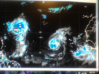
Danielle & Earl in mid ocean with the soon to be feisty Fiona in the far right side of the picture.

The team of scientists that will fly off into Earl are on their way to Barbados. A very brief discussion at 11 said what we already know and the new map grid for Earl shows him clipping the 20/60 box on his way to make a turn up into the Atlantic. Yes, follow the dotted like that Max would always say not to look at and you see it clips the SW side of the 20/60 line.


I'm not sold on anything until recon goes in. Hey, I know some of those guys. They are like the Canadian Mounties...they find their man! Will have better data and better track data when that happens.

Strong surf and rip currents will be part of the beach forecast from the Carolinas northward so if you are planning on going to the beach this weekend, stay safely on the sand where you can take fantastic pics and don't venture out into the surf.

As for Earl.... he looks better tonight after a blow up at the center yet oddly there is another big blow up to his south... hopefully in one of his bands and not some relocation of his center. Who knows? The Gods of Hurricanes I suppose or maybe Neptune himself? I'll know more tomorrow after a good nights sleep when I will be dreaming of hurricanes swirling in my head.

Fun watching Burn Notice. It's like old home week... all my favorite haunts on TV.

Stay tuned, this is no summer finale this is only the start of the action.

Sweet Tropical Dreams
Bobbi

GRAND TURK 34 X X( X) X( X) X( X) X( X) X( X) 4( 4
34 Knots that is...4% chances..low but to see it say Grand Turk is a constant reminder it is moving into our part of the world.

5PM Brief Thoughts on Danielle & Earl and Miami


Super Salient Part of Discussion on Earl as Earl is the storm that needs to be discussed here..

EARL IS FORECAST TO APPROACH A WEAKNESS IN THE RIDGE AXIS
INDUCED BY DANIELLE AND A MID-LATITUDE TROUGH THAT IS FORECAST TO
HELP RECURVE THAT HURRICANE TO THE NORTHEAST. AS EARL APPROACHES
THE WEAKNESS IN THE RIDGE...IT IS EXPECTED TO GRADUALLY SLOW DOWN
AND TURN MORE TOWARD THE NORTHWEST. THE 12Z GFS AND ECMWF MODELS
ARE NOW FORECASTING DANIELLE TO RECURVE TO THE NORTHEAST FASTER
THAN PREVIOUSLY EXPECTED...WHICH ALSO ALLOWS THE SUBTROPICAL RIDGE
BETWEEN EARL AND DANIELLE TO BUILD BACK IN TO THE NORTH OF EARL.
THIS DEVELOPING FLOW PATTERN WOULD FORCE EARL MORE WESTWARD THAN
NORTHWARD AT A SLOWER FORWARD SPEED BY DAYS 4 AND 5.

So basically we have a Hurricane that is "westish" bound around a strong high on Day 4 at a slow speed looking like maybe I'll go wnw, maybe I'll stay west bound...looking for a weakness and a place to call home. And, to complicate matters after fighting off shear and other problems attributed to dry air and dust remnants and the outflow from Danielle ... Earl finally finds his groove and becomes a Category FOUR Hurricane while knocking on the Hebert Box and scaring the beegeebees as my Grandma would say out of the Bahamas if not most of South Florida while forecasters talk on where he is going to make his turn and start pointing at front boundaries and paths to recurve. Oh the drama... oh Earl.. I knew you had it in you!

Mind you this is always subject to change but as of 5pm on Thursday it looks like it's going to get really interesting and we have not even talked on Fiona as she is now still an embryonic wave with 40% chances of development and the soon to be Gaston doesn't even have a circle yet as he is still over Africa.


As for Danielle she's headed for Major status unless something holds her back, she's got 110 mph winds and a joy to watch as she is safely out at sea. And, the wave that is not yet Fiona is stunning... as is that wave over Africa.

Lastly, we are of course expecting Earl to miss the islands, but the NHC takes into consideration all possibilities and gives a percentages for wind possibilities with their forecast. If I was in a town that had these numbers I'd be paying careful attention just in case...

You might want to check it out and see if your home town ends up on the list!! Gee, they even have odds for Barbuda and Guadeloupe is even in it... gee whiz a jacuzzi in St Kitts is in it too. You really have go hmnnnn when you see this as even if it's a long shot it shows that Earl could take the more southern track.

SAINT MAARTEN 34 X X( X) X( X) X( X) X( X) 10(10) 9(19)

GUADELOUPE 34 X X( X) X( X) X( X) 1( 1) 10(11) 3(14)

http://www.nhc.noaa.gov/text/refresh/MIAPWSAT2+shtml/262048.shtml?

So.... keep watching... I think it's a real, real long shot that those islands will ever get affected but I do not think it's a long shot for it to flirt with the Virgin Islands and aim one mean glare at the Turks and the Caicos and if I was Publix I'd start stocking up on water because I smell panic in the tropical wind IF Earl is a category 4 of Day Four.

Mucho problemos to think on ....

Besos Bobbi

Dusty Storm AKA Earl


What we have above is a Dusty Storm named Earl and this image shows the story more than words can say. See the dust ...Saharan Dust that is... caught in the spiral bands to the north of Earl. Until he gets past the dust he is not going to be able to intensify much. That being said, the slower he intensifies the further west he should get though storms are want not to follow the rules.

Fiona or the wave that will be Fiona is following Earl's path except..........Fiona is staying a bit more to the south and should be the bigger threat for the islands and the mainland beyond.


I'm not saying Earl is not a problem for some American Coastline I am just saying I am not sure which beach will be his preferred beach if he does not follow Danielle into the wide open Atlantic.

The other problem with Earl is that the NHC isn't exactly sure where his center is and if they aren't exactly sure where his center is than the track map is pretty much garbage in and garbage out.

Salient Paragraph from NHC Discussion on Earl at 11 AM.

"THE CENTER OF EARL HAS BEEN REPOSITIONED ABOUT 30 NMI SOUTH OF THE
PREVIOUS ADVISORY AND FORECAST TRACK BASED ON A BLEND OF VISIBLE
AND MICROWAVE FIXES. THE INITIAL MOTION ESTIMATE IS A 24-HOUR
AVERAGE OF 275/15...AFTER SMOOTHING THROUGH ALL THE WIGGLES AND
WOBBLES IN THE FIXES. THE OFFICIAL FORECAST TRACK WAS SHIFTED SOUTH
OF THE PREVIOUS ADVISORY DUE IN PART TO THE MORE SOUTHWARD INITIAL
POSITION."

That's a problem for the NHC if he is moving more to the south of his forecasted motion but it's very common for wayward systems to be repositioned temporarily so we have to keep watching.

Waiting for the 11 or waiting for the 5 is the song of the season from now until November.

As for Danielle, look at her spin... 105 mph winds! Still think she has a funny structure for a storm trying to go Cat 3 but hey if it works for it.

And as for the wave that will be Fiona... she's a beauty....really a beauty.

This is getting like A Team.... Plan B always in the works and loving when a plan comes together.

As for me... am doing fine and dandy today while I juggle three things... spending a rest day at home, listening to Stalker Boy music and drinking herbal tea and eating brown rice and steamed vegetables (thanks for the rice cooker too!!) and reading a book and watching loops and well how many things is that? Oh, and bought some tops from the Victoria Secrets sale online...must have gotten that bad habit from my daughter. It's a day to think.... to watch.... to listen...to ponder and watch the sunlight dance in the trees. And, hoping to get to the beach really soon and feel the breeze of Danielle :)

Truth is.......it all depends on timing... everything in life depends on timing as we learned so long ago. IF Danielle moves fast and the door slams shut and the high builds in and if Earl moves fast or slow and where the highs and lows go and it's a strange dance.

Great map graphic rarely used from the NHC... the old 1 2 3 map which I think works well since we have 1 2 3 areas to watch.


So... keep watching and will let you know as soon as I know if Earl or Fiona has two tickets to paradise.

Loop to enjoy to the song that is playing .... should have known, how do I always forget who sings that?? Mental block maybe??

http://www.intellicast.com/Storm/Hurricane/AtlanticSatellite.aspx?animate=true


Besos Bobbi $torm lol no words

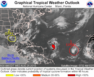
Wednesday, August 25, 2010

5PM Discussion on Danielle and Earl


Been watching some beautiful loops of the various storms and waves and clusters of convection all oozing and spinning around out there.

One thing that needs to be said before going on is that.... the more storms out there the harder it becomes to nail the forecast on the head because each forecast relies upon another forecast for another storm. So, it becomes a process that is very complicated and convoluted.

If the Intensity forecast is wrong on Danielle it can throw off Danielle's effect on Earl's future track. Get it? Think on it. You have so many variables.

Example?

What if a storm formed in the Gulf of Mexico suddenly or the Carib... here comes Earl sniffing along at Danielle's cookie crumbs and the next thing you know he catches a waft of an aroma of a developing tropical cookie in the Carib.... ummm "which way should I go" he thinks?

Danielle wobbles on intensity and has less of an appeal.

A really strong hurricane forms in the East Pacific...how does that play with Earl?

Then there are the usual suspect characters of upper level lows and late summer fronts.

So...when the discussion out of the NHC says, "THE SPREAD OF THE TRACK GUIDANCE DURING THIS TIME HAS INCREASED SINCE THE LAST ADVISORY...AND THE
CONFIDENCE IN THE FORECAST TRACK HAS CORRESPONDINGLY DECREASED." it makes you go hmmnnn. Good discussion by Beven this afternoon, fun to read. On TWC Brian Norcross can't rule out a turn to the left near the NY to Boston area tho it's a long shot but when Brian Norcross can't rule something out.... you don't blink until he has passed Bermuda and is singing "Oh Britain" ya know...well you know. And, you know her intensity seems to pulse up and down more than the stock market.

As for Earl, what can I say yet about Earl?

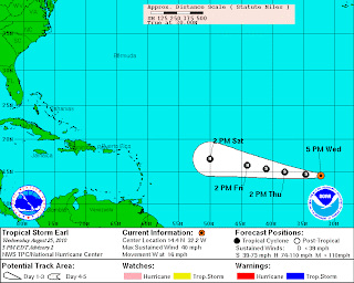
It's a bit too early to call Earl a Florida storm and it depends on how strong Danielle is when she goes north and how fast she goes and how fast Earl develops and if Saturn is properly aligned with Mercury but... the 5pm shows the following cords for the future track of Earl and Earl seems to be straddling the 20/60 Holy Grail mark of Florida storms at 120 hours.

So, what I would do for the next 24 hours or so while he waves goodbye to the beautiful Cape Verde Islands is see how this changes and if the 120 hour point is to the south or north, in or out of the Hebert Box.


INITIAL 25/2100Z 14.4N 32.2W 35 KT
12HR VT 26/0600Z 14.6N 34.6W 40 KT
24HR VT 26/1800Z 15.0N 38.0W 45 KT
36HR VT 27/0600Z 15.5N 41.0W 55 KT
48HR VT 27/1800Z 16.0N 44.0W 65 KT
72HR VT 28/1800Z 17.0N 50.0W 75 KT
96HR VT 29/1800Z 18.0N 55.0W 80 KT
120HR VT 30/1800Z 20.0N 60.0W 80 KT

Keep watching... an going to go to the movies tonight, put aside my principles and just forget that things bother me and remind myself that someone told me recently I am so much prettier than Cameron Diaz...and not let anything bother me because I have two... TWO named storms in the Tropical Atlantic and a possible F storm down the road.

Hello Tropical Storm Earl


Beautiful storm, far away, coming closer...let's think of him as Uncle Earl :)

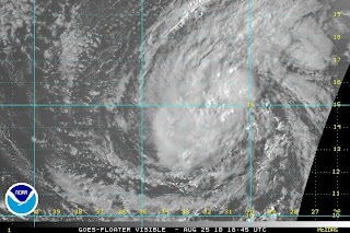
I mean look at him, is he beautiful or what? You rarely see this, almost perfect structure.

Took one look at him when he was over Africa at 30 East and knew he was going to be a player.


NHC didn't even wait til 5pm to upgrade Earl...

Now why do I call this pimp Uncle Earl? He's like some guy sending out Miss Danielle to do his dirty work for him, family favors and she's setting up his track down the road. A lot depends on Danielle if Earl swims with the fishies or if he gets across the ocean towards the islands and Florida.

A lot of variables, but for now I want to enjoy the E storm a little while. Then we can talk turkey.

Besos Bobbi
ps Fiona is following closely behind...

Get Ready for Tropical Storm Earl


The wave in the far Atlantic should be upgraded at 11 to Tropical Depression Status as it's looking more like a well put together Tropical Storm by every hour that passes.

Danielle Drama continues as she stair steps her way across the Atlantic before an eventual pull out for the open Atlantic. A small chance she could get caught up in dead steering currents for a few days and create some nice surf off the the Mid Atlantic States but she is most likely something Bermuda will have to deal with down the road.

Earl is another story. A lot depends on how strong Danielle gets.

Think of Danielle like a big bull doing big damage in a china shop known as the Bermuda High. A strong, intense Danielle cuts a bit path way that allows Earl to follow. A weak messy Danielle cuts a smaller hole and goes slower and keeps Earl further south and depending on a lot of IFs some models show Danielle missing the trof and waiting for the next trof or ticket out of town.

It's a very transitional time in the tropics right now.. cold fronts are finally flowing again and I know that as I have the windows open. Next week I will have the AC turned up all the way again as the heat will be back.

And, behind Earl is a very beautiful system that will most likely become Fiona. But, for today enjoy the beauty of Earl or TD 7.


Remember something... Danielle is 1,926 miles from Miami right now still... far, far away. Even further from the Carolinas.

If that is not a tropical storm behind Danielle I don't know my stuff... going to be an interesting day, an interesting week...

http://www.wral.com/weather/satellite/?m=atlsat

So stay tuned because with Earl on the horizon and Fiona behind him.. we got a lot of tracking to do...

Danielle will cause some drama but think we can safely say she will not bother Florida or the Carolinas though a real small sliver of a chance she can bother the Northern Atlantic Coast .. way Northern..

Earl... and Fiona need to be watched carefully but again Danielle will help write their story like ghostwriters ;)

Besos Bobbi

Beautiful song.... doesn't really relate to Earl but relates to me and am sure someone here can relate to it as well...

http://www.youtube.com/watch?v=I7YShz4jxhA